Cloncurry Airport Runway Damage, Floods Cut Access
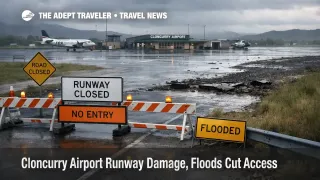
Flooding across North and North West Queensland has cut road access and damaged key infrastructure, including Cloncurry Airport (CNJ), where local reporting says the airstrip has been catastrophically damaged and is currently limited to helicopter landings. That combination removes a usual wet season fallback, flying in when highways are underwater, and it forces most travelers to treat the Cloncurry corridor as temporarily unreachable on a normal schedule.
Travelers are most exposed if their plan depends on a single corridor, for example a drive through the Cloncurry, Queensland, and Julia Creek, Queensland, segment of the Flinders Highway, or a same day arrival into CNJ to meet a tour pickup, a work rotation, or a timed onward flight. With closures stacked across multiple routes, the failure mode is not a delay, it is loss of access, and forced staging in other towns.
Who Is Affected
Anyone trying to reach Cloncurry, Queensland, nearby station stays, mining and work camps, and outback touring loops that rely on the Flinders Highway or the Landsborough Highway should plan for serious constraints. Queensland's Transport and Main Roads district status report lists the Flinders Highway closed between Cloncurry and Julia Creek, and it also lists a Landsborough Highway closure segment tied to flooding, which is enough to break the most common drive paths across this part of the state.
Travelers routing through Mount Isa Airport (ISA), Townsville Airport (TSV), or Cairns International Airport (CNS) can be affected even if they are not headed to Cloncurry, because aircraft and crews rotate across low frequency regional schedules, and because stranded passengers reposition into the nearest operating gateway. That tends to compress last minute hotel inventory, rental cars, and local transport capacity in the towns that remain reachable, especially when travelers cannot complete one way returns.
The disruption also matters to people who are not moving for leisure at all. Queensland Rail reports sections of the Mount Isa line are closed, including the segment between Hughenden and Cloncurry, affecting passenger services and freight recovery planning. When rail freight slows at the same time highways are cut, resupply becomes uneven, and that can show up for travelers as tighter fuel availability, reduced tour operating days, and more conservative accommodation policies.
What Travelers Should Do
First, treat any plan that requires arriving in Cloncurry, Queensland, on a specific day as high risk until there is a confirmed runway and road reopening. If you are already in region, shift to a larger staging hub, lock in a refundable room, and carry extra food, water, and power bank capacity, because reroutes can involve long waits, and limited services. If you are outside the region, do not start an outback drive assuming conditions will improve mid leg, plan for a stop where you can safely turn back.
Your decision threshold should be simple. If your itinerary depends on CNJ reopening, or on a single closed highway segment, rebook now rather than waiting, because the current constraint is physical access, not just schedule congestion. If your trip is flexible and you can stage in a gateway town, it can be reasonable to wait 24 to 48 hours for clearer signals, but only if your bookings are changeable, and you have room in your budget for an unplanned extra night.
Over the next 24 to 72 hours, monitor three practical indicators rather than broad headlines. Watch Queensland road status updates for the specific highway segments your plan needs, because reopenings are often staged and can reverse after thunderstorms. Watch Bureau of Meteorology flood watch and warning updates, because flooding can persist after rain eases, and major river systems can hold roads closed well past the last heavy downpour. Finally, watch for any formal airport operational update, because ABC reporting notes it is unknown when the airstrip will reopen, and emergency access is expected to be prioritized first.
Background
Outback Queensland travel works on thin redundancy. When one highway segment closes, there is often no practical same day detour, and that instantly changes how passengers, crews, supplies, and services move. Flooding closes the road surface first, then the second order effects appear, baggage and catering cannot move, staff cannot commute, fuel deliveries slow, and local businesses pivot to reduced hours or temporary shutdowns. That is why a road closure list is also a proxy for hotel availability, rental car constraints, and tour cancellations.
Airport disruption in remote regions compounds that fragility. ABC reports that Cloncurry's airport has been catastrophically damaged, and that only helicopters can currently land, which removes a key alternative when the road network fails in the wet season. Even after a runway repair plan is set, reopening typically requires inspections, surface work, and a safe pathway for ground handling and emergency response, so traveler usable access can lag behind the first announcement that work has started.
This event also sits inside a broader northern Queensland weather pattern. The Bureau of Meteorology's Queensland video briefing said heavy rain was easing in some areas, but it also emphasized that flooding would persist for days, and it highlighted major flood warning conditions on the Flinders River system. ABC adds that the inland system was weakening and moving south, while coastal impacts were expected to shift offshore early next week, which is a reminder that even as the rain focus moves, river runoff can keep inland access constrained. For longer itineraries, that means the safe plan is staging, flexibility, and decision making based on segment level access, not a general forecast map.
For broader context on the multi region Australia disruption window, see Cyclone Hayley, Queensland Floods Disrupt Australia Travel.
Sources
- Flood disaster taking toll on graziers in north-west Queensland, more rain forecast for tropical coast
- Flooding claims a life as deluge cuts north-west Queensland roads, isolates towns
- Severe weather update: Heavy rain eases, flooding continues for Qld
- Queensland Rail's regional network remains impacted by monsoonal rain in North Queensland
- Road Status Update for North West, Department of Transport and Main Roads