Depression Francis Madeira Airport Delays Through Jan 3
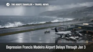
Depression Francis is driving an adverse weather posture for Madeira, Portugal, with regional civil protection warning of heavy rain, strong winds, rough seas, and thunderstorm potential during a defined critical period. The travelers most exposed are those flying in or out of Madeira Airport (FNC), those planning the Funchal to Porto Santo ferry, and anyone depending on high terrain road access for hiking and viewpoint itineraries. The practical move is to treat Friday and Saturday as a disruption window, add buffer to every transfer, and build a same day fallback plan for ferries, tours, and tight flight connections.
The core change for trip planning is that Depression Francis Madeira Airport conditions can force airlines and marine operators to slow operations for safety, which turns normal schedules into rolling delays and last minute cancellations.
Who Is Affected
The first group is inbound leisure travelers arriving on a single daily flight, or on late day arrivals, where a diversion or cancellation can remove the last realistic option to reach the island that day. Civil protection guidance explicitly ties the highest risk window to 1200 p.m. WET Friday, January 2, 2026, through 1200 p.m. WET Saturday, January 3, 2026, and it separately flags strong sea conditions that can run as late as 6:00 p.m. WET Saturday. When that overlaps with peak arrival banks, a single go around sequence can cascade into missed hotel check ins, lost tours, and rebook pressure into the next morning.
The second group is anyone chaining modes between Madeira and Porto Santo. Sea state, wind, and port handling constraints can cancel sailings with limited recovery seats, and that forces travelers into a tight substitute set, either scarce last minute seats on flights, or an extra hotel night in Funchal, Madeira, Portugal, or on Porto Santo, Portugal, depending on where the chain breaks. This is also where the calendar matters, Porto Santo Line says its ferry vessel Lobo Marinho begins annual maintenance at the start of 2026, with its last voyage on Monday, January 5, 2026, and an estimated downtime of about five weeks, which reduces resilience if you were counting on the ferry as your backup mode after the storm window.
The third group is travelers with mountain itineraries, rental cars, and nature plans. Strong winds in high terrain are a direct trigger for closures, and the Instituto das Florestas e Conservação da Natureza (IFCN) says all classified hiking trails in Madeira are closed due to adverse conditions, especially strong winds in high areas. Even if a hotel stay remains comfortable, this kind of closure can erase the most time sensitive activities, such as ridge hikes, levada walks, and viewpoint plans that require safe access and stable footing.
What Travelers Should Do
Start by protecting the links you can still control. For flights, choose earlier departures when you have the option, and build more ground time into airport runs because heavy rain and localized road impacts can turn a short transfer into a missed check in. Check Madeira Airport's live arrivals and departures before you leave your lodging, then again on the way, because the most actionable signal in a wind event is whether aircraft are arriving consistently or stacking into delays and diversions.
Use clear decision thresholds for rebooking versus waiting. If your itinerary depends on a same day connection to Porto Santo, a paid tour with a hard start time, or a late afternoon arrival with no slack, treat the storm window as your trigger to move the flight, add an overnight, or switch to a refundable alternative. The practical rule is simple, if one cancellation would break your trip chain, do not sit in the middle of it, reposition yourself to the most resilient node, usually Funchal near Madeira Airport, with a hotel night you can extend.
Over the next 24 to 72 hours, monitor official updates, not social recaps. Watch the regional civil protection channel for escalation or all clear messaging, keep an eye on IFCN for trail reopening, and check Porto Santo Line for any sailing changes as sea state evolves. If you need a broader pattern reference for how weather disruption propagates through transfers, hotel capacity, and alternates, compare how other destinations manage multi layer disruption in UK Arctic Blast Snow, Rail and Flight Disruption to Jan 5 and SoCal Flood Watch, Burn Scars, Airport Transfer Delays.
How It Works
Weather disruption on islands tends to fail in layers, and the first layer is the approach environment. Madeira Airport sits between ocean and high terrain, so strong winds and convective showers can create wind shear, turbulence, and unstable visibility, which pushes airlines toward go arounds, longer vectors, and occasional diversions when safety margins narrow. Regional civil protection guidance for this event includes wind gusts up to about 56 mph on the coast and about 68 mph in high areas, plus heavy precipitation, hail, and thunderstorms, all of which are ingredients for irregular flight operations.
The second layer is surface access and throughput. Even when flights still operate, heavy rain and wind can slow the road network, reduce the reliability of taxi and rideshare supply, and complicate port operations, which is why island disruptions often show up as missed check ins and missed departures, not just outright cancellations. When sea state is rough, ports and ferries become the choke point, and civil protection explicitly calls out strong sea agitation that can persist beyond the main weather window, extending the time travelers remain stranded on the wrong island.
The third layer is substitution pressure, and this is where costs jump. As travelers pivot from ferries to flights, or from high terrain excursions to indoor plans, demand concentrates into a smaller set of viable options, which tightens last minute hotel inventory and raises the odds you pay more for a shorter, less ideal trip. If you want a durable mental model for how climate driven disruptions force operator contingency planning across modes, The 2025 European Heatwave's Impact on River Cruises is a useful parallel, even though the asset is different, the system behavior is the same, constrained capacity, hard safety limits, and expensive last minute substitutions.