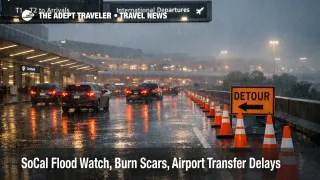
SoCal Flood Watch, Burn Scars, Airport Transfer Delays
A SoCal flood watch airport transfers are turning high variance across Los Angeles, California, and nearby counties as another round of rain raises flash flooding and debris flow risk through New Year's Day. Travelers headed to airports, especially Los Angeles International Airport (LAX), Hollywood Burbank Airport (BUR), and Ontario International Airport (ONT), are exposed to freeway ponding, canyon road closures, and burn scar evacuation warnings that can break curbside timing. Build extra transfer time, pick routes that avoid foothill shortcuts, and treat any drive that crosses the Santa Monica Mountains or San Gabriel foothills as a detour day.
The SoCal flood watch airport transfers problem is mostly about getting to the terminals on time, because debris flows and road restrictions can sever the fastest corridors even when flights keep operating. The National Weather Service (NWS) flood watch for the Los Angeles and Oxnard forecast area was issued early December 31, 2025, and runs from Wednesday evening through Thursday evening, with explicit debris flow and rockslide concern near recent burn scars and in canyons.
Los Angeles County also activated its winter storm emergency page and posted that evacuation warnings for zones near recent burn areas would go into effect at 11:00 a.m. on December 31, 2025, with guidance that warnings can be upgraded quickly if conditions deteriorate.
On the roads side, Caltrans District 7 said it will fully close a 3.6 mile segment of Topanga Canyon Boulevard, State Route 27 (SR 27), between Pacific Coast Highway (PCH) and Grand View Drive starting 5:00 p.m. on December 31, 2025, citing predicted rain and potential debris flows, and noting saturated slopes after the prior storm.
Who Is Affected
Travelers staying in the Santa Monica Mountains, the Malibu coast, the Palos Verdes Peninsula, the San Fernando Valley foothills, the San Gabriel Valley, and the Santa Clarita Valley are in the highest variance bucket, because those itineraries often rely on canyon roads and a small number of chokepoint interchanges that are vulnerable to closures and spillback traffic when rain rates spike.
Anyone driving to a flight or a timed event on December 31, 2025, or January 1, 2026 is also exposed even if they are not in a burn scar zone, because detours push more vehicles onto the same arterials, and rideshare pickup patterns degrade when drivers avoid hills and work zones. That is especially true for curbside timing at LAX and for hotel to airport runs that cross the basin during the overnight and morning rain windows called out by local authorities.
Rose Parade visitors are a separate mobility case. The Tournament of Roses lists the parade start at 800 a.m. on January 1, 2026, and it also notes route closures beginning at 1000 p.m. on December 31, 2025 through 2:00 p.m. on January 1 along key Pasadena corridors, which can compound storm detours and slow morning access to BUR and other nearby pickup points.
What Travelers Should Do
For flights, plan around the road network first. For Los Angeles International Airport (LAX), treat 60 to 90 minutes of extra buffer as the default when you are crossing the basin, and assume you may need more if your route normally uses foothill shortcuts or canyon segments. For Hollywood Burbank Airport (BUR), Ontario International Airport (ONT), John Wayne Airport (SNA), and Long Beach Airport (LGB), the same logic applies, leave earlier than you think you need, and avoid last mile routes that funnel into foothill drainages. If your hotel is near Malibu or Topanga, assume SR 27 closures and PCH work zones can force long reroutes and surge pricing.
Use clear thresholds for rebooking versus waiting. If you are on separate tickets, you have a paid tour start, or you must check bags close to cutoff, a storm day is not the time to gamble on a tight transfer. Move to an earlier flight, a later flight with slack, or a buffer night near the airport if your planned drive crosses canyons or burn scar areas under evacuation warning. If you receive an upgraded evacuation order, treat that as non negotiable and relocate immediately, because the travel risk becomes access loss, not just delay.
Over the next 24 to 72 hours, monitor three layers and make them agree before you commit to a departure time. Track NWS watch and warning upgrades for your exact corridor, watch Los Angeles County alert updates for evacuation changes, and check Caltrans road status for closures that change fastest, including SR 27 and any PCH restrictions. If you are attending the Rose Parade, treat the 1000 p.m. December 31 closure start and the 800 a.m. January 1 parade window as hard constraints that can turn a short drive into a long detour, even without major flooding.
How It Works
Flood watches are a traveler mobility signal, not just a weather headline. When NWS issues a flood watch over broad coastal and valley zones, it means rainfall totals and intensities can produce runoff that overwhelms drainage, floods low spots, and destabilizes canyon slopes, which is why the same advisory also flags debris flow and rockslide risk near recent burn scars. In Southern California, that hazard stack concentrates on the exact places travelers like to use as shortcuts, canyon connectors, and scenic routes between coastal hotels and airport basins.
The burn scar layer is where disruption turns from slow traffic into sudden access loss. Without vegetation, hillsides shed water and sediment quickly, and debris flows can block roads with little warning, which is why Los Angeles County's evacuation warning language emphasizes preparation and the possibility of an upgrade to an evacuation order. Even when the hazard stays localized, every closure pushes more vehicles onto parallel corridors, which triggers second order effects that travelers feel immediately, rideshare scarcity and surge pricing, longer hotel check in delays, and missed flight connections when late arrival forces carrier rebooking onto later banks.
Event day traffic multiplies the problem. The Rose Parade's published closure window beginning at 1000 p.m. on December 31, 2025 through 200 p.m. on January 1, 2026 creates predictable choke points in Pasadena, and those detours can collide with storm reroutes and reduce the margin for anyone trying to reach BUR after an early morning hotel checkout.
If you want a comparable recent reference point for how storms propagate through air and ground layers, see California Storm Hits Flights, Highways Through December 25 and SoCal Storm Brings Flood Risk And Flight Delays. For coverage planning and what is usually reimbursable when weather and evacuation warnings disrupt a trip, see Travel Insurance - Travel News and Guides from The Adept Traveler. For this specific window, the practical takeaway is that SoCal flood watch airport transfers should be planned like a high variance ground operation through January 1, 2026, with extra time and a reroute mindset.