Storm Goretti UK Snow, Wind Risks for Travel Jan 8 to 9
Storm Goretti is set to intensify the United Kingdom's winter disruption as a deep area of low pressure pushes in on Thursday night and into Friday, bringing a mix of heavy snow, strong winds, and heavy rain in different parts of the same system. Travelers with rail trips, regional flights, and airport surface transfers in England and Wales are most exposed, especially if they rely on last trains, same day connections, or long drives across higher ground. The practical move now is to widen buffers, protect overnight options, and decide early whether to travel before the peak window or to delay until conditions stabilize.
The Met Office describes this as a "multi hazard" setup where snow is more likely on the northern edge of the low while wind and rain affect areas farther south, and it has emphasized that warning areas and severity can change as the storm track firms up. In plain terms, Storm Goretti UK travel disruption means plans that were merely fragile in the cold snap can break across multiple modes in the same night.
Who Is Affected
The Met Office has issued a yellow snow warning from 600 p.m. Thursday, January 8, 2026, through 1200 p.m. Friday, January 9, 2026, spanning a broad band that includes parts of the Midlands, the West Midlands, and multiple local authority areas across Wales, plus selected areas in the East of England, the South West, and farther north into parts of Yorkshire and the Humber. This footprint captures many of the road and rail approaches travelers use to reach major airports and city stations, so the highest risk is not just in the air, it is getting to the platform, the terminal, or the rental car return on time.
A separate yellow wind warning is in place for southwest England from 300 p.m. to 1159 p.m. Thursday, January 8, 2026, covering Cornwall, Devon, the Isles of Scilly, and Plymouth. Strong coastal gusts in that window can force slower road speeds, reduce rail resilience along exposed stretches, and disrupt ferry and regional aviation operations even if the snow axis ends up farther east.
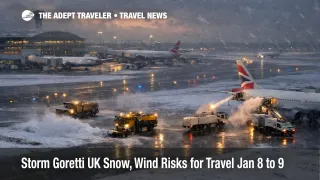
Air travelers should treat airport access as the likely failure point first, then aircraft and crew positioning second. Airports that serve the warning footprint and its approaches include Heathrow Airport (LHR), Gatwick Airport (LGW), Birmingham Airport (BHX), Bristol Airport (BRS), Cardiff Airport (CWL), and East Midlands Airport (EMA). On a multi hazard night, an airport can remain technically open while still losing departure rate due to de icing, slower turn times, and constraints moving staff and equipment around the airfield.
Rail passengers are exposed in a different way, because winter impacts often reduce service frequency and then compress remaining capacity into fewer trains. That tends to raise the cost of being wrong about timing, since a missed connection can quickly become an overnight, particularly outside London where options thin out after the evening peak. For context on how fast winter disruption can jump from Scotland into wider UK air and rail impacts, see UK Snow Hits Scotland Rail, Airports January 5, 2026.
What Travelers Should Do
Start by protecting your first hard dependency, which is usually surface access. If you are traveling Thursday evening or Friday morning, add time for slow roads, allow for last minute platform or gate changes, and avoid planning that requires a single precise connection to work, especially if you are traveling with checked bags, kids, or mobility needs. Where you can, shift to earlier arrivals at the airport or station, and keep your ground transfer options flexible so you are not locked into one last mile mode.
Use decision thresholds that match how many genuine backups you have. If your itinerary depends on a last train, a late evening short haul flight, or a self connection onto a long haul departure, rebooking earlier on Thursday or delaying until later Friday or Saturday is often the safer call than waiting for day of updates, because recovery capacity tends to shrink as disruption spreads across regions. If you have multiple departures per day on the same route and you are already in a flexible hotel, it can be reasonable to wait, but only if you can absorb an overnight without breaking something downstream like a cruise check in, a tour start time, or a non refundable lodging night.
Over the next 24 to 72 hours, monitor three signals and act when they change. First, watch the Met Office warning map for whether the snow axis shifts north or south, and whether any yellow areas are shortened, expanded, or escalated. Second, watch your rail operator and National Rail updates for reduced timetables and for what time the day after schedule is finalized, because that timing tells you how likely it is that early Friday trips will run as planned. Third, watch airline and airport advisories for waivers and for de icing constraints, because the best rebooking outcomes usually go to travelers who move while seats still exist, not after queues form.
Background
Named storms do not automatically mean the worst impacts will be centered over the United Kingdom, and the Met Office has noted that Storm Goretti was named by Météo France because the strongest winds are expected across northern France. For UK travelers, the main planning problem is the collision between the deepening low and the existing cold air mass, which can turn rain to snow quickly, produce drifting over higher routes, and layer wind impacts onto already icy access roads.
Disruption then propagates through the travel system in predictable layers. On roads, ice and drifting reduce average speeds and increase incident risk, and that can lock up airport approaches and station drop offs, even when the transport operator itself is still running. On rail, snow and ice can affect points, overhead lines, and third rail power supply, and even short service gaps can cascade into cancellations because trains and crews end up out of position. In aviation, de icing and slower ground operations stretch turnarounds, and when a single rotation is lost, later flights can fall over due to aircraft availability and duty time limits.
Second order impacts are where plans tend to break. When rail and air capacity both tighten at once, remaining seats are quickly consumed, taxi and rideshare availability becomes uneven, and hotels near airports and major stations absorb stranded travelers who cannot reach their final destination the same night. That hotel compression then makes it harder to wait out the storm on favorable terms, especially for families, groups, and anyone needing accessible rooms.