Storm Goretti UK Ferries And Airports Disrupted Jan 9
Storm Goretti is now producing confirmed operator actions across the United Kingdom's southwest approaches and the English Channel, including early airport closures in the Channel Islands and cancelled ferry sailings on key crossings. Travelers using Channel routes, coastal roads, and island air links are the most exposed, especially where itineraries depend on same day connections across modes. The practical move is to protect safety first, then decide quickly between rerouting to rail or air alternatives, or sheltering overnight near your last reliable gateway.
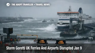
The Met Office upgraded parts of southwest England to a red warning for wind, covering the Isles of Scilly and much of Cornwall, with the warning window posted as 400 p.m. to 1100 p.m. local time on Thursday, January 8, 2026, and gusts forecast at 100 mph or more in exposed coastal locations. For travelers, that is not "plan for delays," it is "expect outright cancellations," because ports, airfields, and rail corridors will not run normal operations when wind and sea state exceed safety limits.
In the Channel Islands, Guernsey Airport (GCI) says it will close at 600 p.m. Thursday, January 8, 2026, and expects to reopen at 700 a.m. Friday, January 9, after early morning safety inspections, with the first inbound flights currently expected after 830 a.m. Alderney Airport (ACI) is also set to close at 600 p.m., with some disruption possible earlier in the day as winds build.
On the sea side, Irish Ferries' Dover and Calais sailing updates show multiple "No Sailing" entries on Friday, January 9, 2026, including several Dover to Calais departures and several Calais to Dover departures, materially reducing same day Channel capacity and pushing more demand into the sailings that do operate. Even when winds start easing, port sequencing and ship positioning can keep schedules uneven into the afternoon.
Who Is Affected
The highest risk group is anyone holding a date fixed Channel crossing or island hop that must happen on Thursday night, January 8, or Friday, January 9, 2026, because wind driven cancellations break the entire chain of onward travel. That includes travelers driving to ports for a morning crossing, then connecting to a timed rail or coach segment, as well as passengers flying to a small airport, then planning to connect onward the same day on a separate ticket.
Channel Islands itineraries are particularly brittle because there are fewer daily frequencies, fewer diversion options, and limited nearby hotel inventory. When a small airport closes early, the displacement is not just "a later flight," it can become "a forced overnight," and the next day's first flights tend to be capacity constrained because aircraft and crews have to return to base and pass airfield inspections before normal flow resumes.
Travelers transiting between the UK and France are also exposed because storm naming and impact extend beyond one jurisdiction. The Met Office notes the strongest winds are expected in the Channel Islands and northern France, which helps explain why you can see simultaneous disruption on both sides of the crossing, limiting reroute options even if one terminal appears to recover sooner. Wider Europe impacts have already been reported alongside the UK warnings, which matters because airlines and crews that would normally recover overnight can be pulled into broader network disruption over the weekend.
What Travelers Should Do
If you are scheduled to cross the Channel or fly to or from the Channel Islands from Thursday evening, January 8, through Friday morning, January 9, 2026, act as if the most fragile segment will fail. Move check in earlier than usual, avoid checked baggage where possible, and pre book a refundable backup hotel near your departure port or airport so a late cancellation does not force you into a long, unsafe drive or a last minute price spike.
Use a hard decision threshold instead of waiting indefinitely. If your sailing or flight is not confirmed as operating by the time you would normally leave for the terminal, pivot to sheltering overnight, or to a different corridor with higher frequency and redundancy, such as the Channel Tunnel rail option if it is operating and you can reach it safely, or a later Friday crossing once operators have completed inspections and repositioning. Treat separate ticket connections as a nonstarter, because a single missed leg can strand you without protection.
Over the next 24 to 72 hours, monitor three things in parallel, the Met Office warning updates for wind timing and residual snow risk, your specific operator's live status page for your sailing or flight number, and the knock on constraints that do not show up as a cancellation, such as delayed departures, longer check in cutoffs, and limited space on replacement sailings. Once the peak winds pass, the recovery story becomes a capacity story, how quickly aircraft, crews, ships, and port slots can be reset without creating a second day of rolling disruption.
Background
Storm driven travel disruption propagates through the system in layers. The first order effect is safety based shutdown, wind limits close runways, constrain crosswind operations, and create turbulence and approach instability, while sea state and gusts force ports to reduce movements, cancel sailings, or hold vessels offshore. The second order ripple is positioning, when a flight or sailing cancels, the asset is now on the wrong side of the route for the next scheduled trip, and crew duty limits can prevent a simple "catch up" turn even if conditions improve later.
Those ripples matter most on thin routes. A large hub can sometimes absorb a bank of delays, but a small island airport or a ferry corridor with a fixed set of daily rotations has fewer recovery levers. That is why early closures in the Channel Islands can echo into Friday and even Saturday schedules, and why a run of Channel cancellations can raise prices and reduce availability across remaining options for cars, foot passengers, and freight. For broader context on how European weather disruptions have been spilling into air and rail networks this week, see Eurostar Snow Cancellations London Paris, and for earlier UK focused coverage of the storm setup, see Storm Goretti UK Travel Disruption January 8 and 9.