Japan Heavy Snow Warning Hits Travel Jan 21 to 25
Japan's transport and weather authorities are warning that heavy snow could disrupt travel across wide areas of the country from January 21 to January 25. The advisory targets northern and western regions, especially the Sea of Japan side, and explicitly urges people to avoid non essential travel as conditions evolve. For travelers, the practical move is to pause or re sequence itineraries so your longest transfers, like airport to resort, or city to city rail, do not sit inside the highest risk window.
The change matters because this is not a single airport delay story. A multi day snow pattern can close highways, degrade local rail reliability, and cut off ski and onsen towns even when major gateways still appear operational. Once roads are intermittently closed, timed reservations, paid entries, and tour departures become the first casualties, and those losses can then cascade into missed check ins and forced overnight stays.
Who Is Affected
The most exposed travelers are those moving along the Sea of Japan coast belt from Hokkaido through the Tohoku region, the Hokuriku region, and into the Sanin area of the Chugoku region. Japan's Meteorological Agency and the transport ministry's joint messaging emphasizes that warning level snow can persist for days, increasing the likelihood that impacts expand from mountains into lower elevations and urban approaches.
Ski and onsen itineraries are particularly fragile because the last mile is usually a bus, a local train, or a mountain road segment with limited alternatives. If your plan relies on arriving at a station at a specific minute to catch a resort shuttle, you should treat that as a high risk design during this window. Even when the Shinkansen runs, the feeder layer can fail, and that is where travelers lose the most money and time.
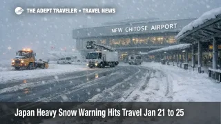
Air travelers using northern gateways should also plan for irregular operations, including cancellations that concentrate quickly at the most snow exposed airports. Recent disruptions have shown how fast schedules can compress around New Chitose Airport (CTS) when winter systems intensify, and that can ripple into missed onward rail and coach connections.
What Travelers Should Do
If you have not departed yet and your itinerary includes long ground transfers to a ski area or onsen town, the cleanest risk reduction is to move the transfer outside the January 21 to January 25 window, or insert an overnight stop at your gateway city so you are not forced to complete a mountain transfer on the same day as a delayed arrival. The goal is not perfection, it is creating a recovery day that does not destroy the rest of the trip.
Use a decision threshold for rebooking versus waiting. If your arrival day includes a timed tour pickup, a limited frequency resort bus, or a nonrefundable check in rule, treat that as a rebook now trigger. If you are in a large city with multiple rail options and can shift activities without losing money, waiting can be reasonable, but only if you are actively monitoring alerts from your airline, your rail operator, and the road agencies that control closures.
Over the next 24 to 72 hours, watch for two signals that conditions are worsening. One is language about prolonged impacts, including multi day warning level snow, which implies recovery gaps are smaller than usual. The second is preventative road management, where expressways and parallel national routes can be closed at the same time, which can strand resort bound traffic and tour buses even when snowfall looks manageable from a hotel window.
For travelers who want a concrete model of how these winter disruptions propagate through Japan's mixed air and rail system, see our earlier reporting on Japan Snow, Flight Waivers, Rail Suspensions Jan 13, 2026 and Weather Delays Across Japan Hit Key Airports December 8. Those playbooks are useful because airlines often publish flexible rebooking tools first, and ground transport impacts can lag by hours while still causing the largest itinerary losses.
How It Works
A strong winter pressure pattern can keep snow bands anchored along the Sea of Japan side for days, and the Japan Meteorological Agency notes that the Japan Sea Polar air mass Convergence Zone, often shortened as JPCZ, can intensify snowfall when it stalls over the same corridor.
The first order effect is physical capacity loss, roads that close, rail that slows or suspends segments, and airports that require more deicing time and spacing. The second order ripple is network timing failure. When a domestic flight arrives late, the traveler misses the last practical onward connection, when a bus cannot reach a resort base, tours cancel and hotels absorb unexpected arrivals, and when reservations are timed, even a two hour slip can erase a paid day of activities. The third layer is recovery friction, because snow events that stretch for multiple days reduce the system's ability to reposition aircraft and crews, clear backlogs, and reopen mountain corridors at the pace travelers expect in a one day storm.