Storm Ingrid UK Rail Disruption Hits Southwest
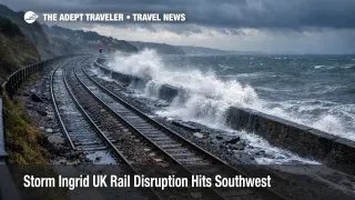
Storm Ingrid battered southwest England with heavy rain, strong coastal winds, and flood risk that translated into hard transport failures on the region's most fragile links. Rail service through the South Devon coastal corridor was shut and then only partially restored after inspections, with operators warning that trains would run at reduced speeds and remain prone to cancellations and delays while recovery and checks continued. At the same time, flooding in Cornwall forced additional line closures and replacement transport, turning what is normally a straightforward rail day into a chain of buses, slower running, and missed connections.
For travelers, the practical change is that the South West's rail spine behaved like a single point of failure. When the Exeter St Davids to Newton Abbot segment is constrained, long distance services between London Paddington and Penzance, and cross country flows that feed Plymouth and Cornwall, lose their most reliable pathing and crew rotation options, even if trains are technically running elsewhere. Met Office warnings framed the setup as wet and windy conditions capable of travel disruption, and that translated into real, timetable level impacts rather than minor delays.
Who Is Affected
Rail passengers heading to, from, or through Exeter St Davids, Newton Abbot, Plymouth, and onward to Cornwall are the most directly exposed, including long distance Great Western Railway travelers and CrossCountry passengers whose routes rely on the same constrained segment. Travelers bound for coastal stops on the South Devon line are also affected because storm debris risk and sea wall vulnerability concentrate disruption into short but critical high tide windows, and recovery can remain uneven well after winds ease.
Cornwall travelers face a second, separate problem where flooding closed the Par to Newquay line, which matters for both leisure trips and air connections at Cornwall Airport Newquay (NQY). If a plan depends on a precise rail to bus to rail chain, or a last train into a hotel, cruise pier, or airport access road, the failure mode is usually the transfer, not the first departure. That is why disruption in Devon and Cornwall quickly propagates into missed long distance connections, short notice rebooking on remaining seats, and higher overnight pressure in rail gateway cities.
Road travelers are also affected in a less predictable way, because flooding and debris push traffic onto fewer reliable corridors at the same time replacement buses and diverted travelers increase demand. If you are driving to Bristol Airport (BRS), Exeter Airport (EXT), or a ferry terminal transfer from a rail hub, treat the last hour as the weak link and plan for slowdowns that do not show in normal routing assumptions.
What Travelers Should Do
Act like your schedule is only as strong as the first hard cutoff you cannot miss, then build buffer backward from that point. If you must travel today, check National Rail for your full journey, then check your specific operator update, and assume rail replacement vehicles will be busy and slower than normal in wet conditions. If your trip includes Cornwall, treat the Par to Newquay segment as bus dependent until the flooding related closure clears, and plan station arrival times that absorb a missed bus as well as a missed train.
Use a clear decision threshold for rebooking versus waiting. If missing one connection forces an unplanned hotel night, breaks a flight check in window, or risks a ferry boarding cutoff, move now to an earlier departure, a different corridor, or an overnight reposition in Exeter, Plymouth, or another gateway where you can restart in the morning. National Rail also extended validity for tickets dated Friday, January 23, Saturday, January 24, and Sunday, January 25, 2026, through Monday, January 26, 2026, on the affected route, which gives flexibility if delaying is the safer option. If you do delay, lock in accommodation early, because stranded demand concentrates quickly when the main rail spine is impaired.
Over the next 24 to 72 hours, monitor three signals and act when they change. First, watch the Met Office warning map and forecasts for renewed heavy rain or coastal wind timing that could trigger additional inspections or precautionary slow running. Second, watch National Rail incident updates for whether the corridor returns to normal line speeds, or remains limited service, because reduced speed operations often keep delays and cancellations elevated even after the headline closure ends. Third, watch flood warning status in Devon and Cornwall, because river and coastal alerts are an early indicator of road closure risk and bus reliability, which is now part of your rail plan.
Background
Storm Ingrid was named by Portugal's national weather service, and the Met Office flagged a slow moving low pressure system capable of heavy rain, gusty winds, and coastal wave impacts that can disrupt travel, particularly where ground is already saturated. In southwest England, that weather couples directly into rail vulnerability because the South Devon coastal railway is exposed, and any sea wall damage or debris risk forces safety checks, closures, and speed restrictions on the only continuous rail artery into much of the region.
Disruption propagates in layers. First order effects begin at the source, which is track access, inspections, and physical constraints on line speeds, plus localized flooding that shuts branch lines and forces buses. Second order ripples hit connections and crew flow because long distance diagrams depend on predictable turn times through Exeter and Newton Abbot, and once trains and staff drift out of position, cancellations can persist even when weather improves. A third layer then reaches aviation and lodging, because missed rail arrivals drive short notice demand for reprotected seats and hotel rooms near gateway stations and airports, and because coaches and taxis become the default alternatives at the exact moment roads are least reliable.
For related UK resilience planning on stacked disruption weeks, see Storm Goretti UK Snow, Wind Risks for Travel Jan 8 to 9 and Gatwick Rail Link Closures, Three January 2026 Weekends. If disruption forces an unplanned London overnight, the fastest way to salvage value from the stop is having a ready city plan, see London Travel Guide: The Ultimate 7-10 Day Itinerary for First-Time Visitors.
Sources
- Warnings in force with further wet and windy weather on the way, Met Office
- Incident: Plymouth (Storm Ingrid disruption), National Rail
- Storm Ingrid travel information, CrossCountry
- Dawlish rail line to shut following storm warning, ITV News
- Devon flood alerts and warnings, GOV.UK
- Cornwall flood alerts and warnings, GOV.UK
- Storm Ingrid washes away part of Teignmouth's historic pier, The Guardian