Winter Storm Gianna East Coast Flight Waivers Jan 30 Feb 2
A strengthening coastal storm is forecast to bring a fresh round of weekend travel disruption along the U.S. East Coast, with snow, strong winds, and coastal hazards building from the Southeast into parts of the Mid Atlantic and New England. The highest near term risk is concentrated in the Carolinas and adjacent corridors where Winter Storm Watches and local briefings flag potentially significant snowfall bands, blowing snow, and bitter wind chills. Travelers with Friday to Monday flights, long drives, or same day cruise plans should shift to buffer heavy schedules, use waivers early, and avoid tight connection chains where a single cancellation can strand an itinerary.
The Winter Storm Gianna East Coast flights setup matters because it is arriving behind Winter Storm Fern, so even airports outside the heaviest snow band can see knock on delays from aircraft and crews being out of position.
Who Is Affected
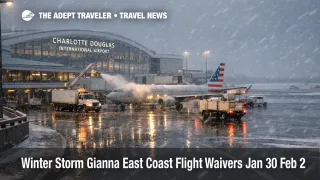
Air travelers are the most exposed, especially those routed through Hartsfield Jackson Atlanta International Airport (ATL), Charlotte Douglas International Airport (CLT), Raleigh Durham International Airport (RDU), Norfolk International Airport (ORF), and Wilmington International Airport (ILM), plus travelers connecting onward to Northeast hubs if cancellations build in the Southeast departure bank. American Airlines posted a change fee waiver tied to Winter Storm Gianna for many Southeast airports, with covered scheduled travel dates from January 30, 2026 through February 2, 2026, and rebooking allowed into early February under the carrier's conditions.
Road and rail travelers should expect the usual storm trap where the airport itself reopens faster than surface access does, especially when snow and wind reduce highway capacity, and when refreeze creates black ice during the cold air behind the system. In central North Carolina, the National Weather Service briefing highlights a Winter Storm Watch, widespread snow potential, and gusty winds that can reduce visibility and create drifting, plus lingering black ice risk after the heaviest precipitation ends.
Cruise passengers sailing from East Coast homeports and travelers using ferries and coastal road transfers face a separate operational risk, strong winds and hazardous seas. The National Weather Service briefing for the Wilmington, North Carolina area flags hazardous winds and seas over coastal waters late Saturday into Sunday, conditions that often slow port moves, delay pilot operations, and prompt itinerary adjustments. At least one cruise line has already shortened a sailing to avoid the developing storm pattern, a signal that schedule protection is now driving real itinerary decisions.
What Travelers Should Do
Travelers with flights from Friday evening through Sunday should use waivers as soon as they appear, and should build more buffer than usual between segments because rebooking inventory compresses quickly on winter weekends. If an itinerary depends on a single critical segment, for example a short hop into Charlotte Douglas or Raleigh Durham, consider moving that segment earlier on January 30, 2026, or later on February 2, 2026, rather than trying to thread peak storm hours.
For rebooking thresholds, treat a Winter Storm Watch plus forecast winds as a high probability disruption signal when a trip includes short connections, separate tickets, or the last flight of the day. If the plan includes a cruise embarkation, a wedding, a timed event, or a non refundable tour, the decision line should be simple, rebook once you can land at least a day early, or once the waiver allows a date shift without extra fees.
Over the next 24 to 72 hours, monitor three things that usually decide whether disruption stays local or goes national, updated snowfall placement, wind and coastal hazard messaging, and airline capacity recovery at key hubs. In the Carolinas, local briefings emphasize uncertainty in where the heaviest snow bands set up, and they also flag very cold wind chills that can keep ramps and roads hazardous after plows finish. For broader context on how cascading delays build when the system is already stressed, see U.S. Air Traffic Control Privatization: Reality Check.
How It Works
A coastal storm disrupts the travel system in layers, and the most important traveler takeaway is that "open" does not mean "moving." At the source layer, snow and wind reduce airport arrival and departure rates, deicing adds turnaround time, and gate holds increase when inbound flights cannot land on schedule. When winds rise, ground stops and air traffic management initiatives can stretch flight times and create holding that burns crew duty limits, which is how a storm in the Carolinas can trigger cancellations in cities far outside the snow line.
The second layer is connections and positioning. When a hub loses a departure bank, aircraft and crews that were supposed to fly onward never arrive, and airlines often cancel the downline legs preemptively to protect the next morning schedule. Because this storm is lining up behind Winter Storm Fern, the system starts with less slack, which raises the odds of rolling cancellations that persist into Monday even after the heaviest precipitation ends. If the trip looks fine on paper but depends on multiple short segments, that is the itinerary type most likely to fail first.
The third layer is ground access and coastal operations. Snow and wind can close highway segments, slow rental car turnarounds, and lengthen rideshare pickup times at terminals, while the bitter cold that follows can refreeze meltwater into black ice that lingers through early morning departure windows. Along the coast, hazardous winds and seas can delay port moves and tighten cruise embarkation windows, which is why same day cruise turnarounds are a risky pattern during winter coastal storms. Recent storm recovery also shows how quickly East Coast surface mobility can break in winter conditions, which is relevant for travelers using New York area connections and transfers. See NYC Ferry Ice Suspension Disrupts Routes January 28.
Sources
- Travel alerts, Winter Storm Gianna Southeast U.S., American Airlines
- NWS Raleigh Winter Weather Briefing PDF, January 29, 2026
- NWS Wilmington Winter Weather Briefing PDF, January 29, 2026
- Delta SkyWatch Weather Advisories overview
- A nor'easter will bring snow and flooding, Washington Post, January 29, 2026
- Carnival ends cruise early to avoid developing Nor'easter, cruise.blog, January 2026