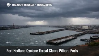
Port Hedland Cyclone Threat Clears Pilbara Ports
Pilbara Ports has moved to clear vessels from Port Hedland and other major export ports in Western Australia's Pilbara as a tropical low develops faster than expected and approaches cyclone strength. The travelers most exposed are those transiting through Port Hedland, Australia, and nearby gateways for work trips, cruises that rely on regional positioning, and self drive itineraries that depend on open highways and reliable fuel and lodging. The practical next step is to treat the next 24 to 72 hours as a high volatility window, tighten buffers, and make go no go decisions using official Bureau of Meteorology updates plus port, airport, and operator notices.
The Bureau of Meteorology has a cyclone watch covering the Pilbara coast from Onslow to Port Hedland, including Karratha, and forecasts include the potential for gales and heavy rainfall that can trigger flash flooding and rapid road condition changes. Local reporting also indicates the system is expected to reach at least category two strength, which raises the odds of preemptive shutdowns that disrupt travel even before the worst conditions arrive.
Who Is Affected
Travelers with any itinerary that touches Port Hedland's port or airport system are the first group at risk, including fly in, fly out work travel and anyone connecting onward to smaller Pilbara communities. Port operations are tightly coupled to local transport capacity, and when vessels are cleared and terminals reduce activity, the knock on effects often show up as changed shift timing, staffing constraints, and volatile demand for the same limited pool of flights and rooms.
A second group is road travelers, including campers and self drive visitors, because the Pilbara's disruption pattern is usually not a single closure that stays closed. Heavy rain and wind can close a corridor, reopen it briefly, and then close it again as bands rotate through or as water crosses low points. That stop start pattern can strand travelers between towns where inventory is thin, and where fuel, groceries, and rental vehicles are not easy to replace at the last minute.
A third group is travelers positioned in Perth, Australia, or other safer hubs who plan to move north later in the weekend. When port and cyclone preparations trigger repositioning, hotel availability can tighten in the hubs that still have reliable air service, and pricing can jump quickly for the remaining flexible inventory. If your trip includes tours, fishing charters, offshore visits, or remote stays, assume operators may suspend service before the cyclone crosses simply because moving staff and guests safely becomes the dominant constraint.
What Travelers Should Do
Start with immediate actions and buffers. If you are due to travel into the Pilbara from February 6 to 8, 2026, keep your schedule loose, avoid same day stacking across flights and long drives, and hold at least one buffer night on either side of any critical commitment. Check your airline's travel alerts, then check the airport alerts for Port Hedland International Airport (PHE) and Karratha Airport (KTA), because cancellations can be announced with little lead time once winds and rainfall approach operational limits.
Use clear thresholds for rebooking versus waiting. If the Bureau of Meteorology watch escalates to warnings for your specific coastal segment, or if your accommodation, tour operator, or employer site issues a stand down notice, treat that as the trigger to move travel earlier, delay travel, or reroute to a non impacted base rather than trying to thread the needle. If your itinerary relies on a single road corridor or a single flight rotation, you should bias toward changing plans sooner, because recovery capacity in the Pilbara can be limited even after conditions improve.
Over the next 24 to 72 hours, monitor three streams in parallel. First, Bureau of Meteorology cyclone updates for track, intensity, and watch or warning zones. Second, Pilbara Ports advisories as the ports progress through their cyclone stages, since closures and reopening timing can shape local transport demand and staffing. Third, airline and airport updates for any rolling cancellations, and for changes in terminal access, parking, or ground transport availability. For a recent example of how cyclone driven access issues can ripple across transfers and lodging even after landfall, see Cyclone Fytia Madagascar Floods Disrupt Roads and Ferries.
How It Works
Cyclone threats propagate through the Pilbara travel system in layers, and the first layer is operational precaution. Ports clear vessels because gale force winds, heavy rain, and tidal changes can damage infrastructure and make berth operations unsafe, so traffic is pushed out to sea and terminals reduce activity until conditions pass. That is a protective move, but it also reshapes demand on land, because crews, contractors, and travelers reposition at the same time and compete for limited transport and rooms.
The second layer is airport and airline reliability. Even if runways remain usable, aircraft and crews have to be in position, passengers have to reach the terminal, and ground handling has to function in degraded weather. When multiple flights are canceled, rebooking options compress quickly, and the remaining services can sell out, which is why tight itineraries into Port Hedland International Airport (PHE) and Karratha Airport (KTA) become fragile well before the cyclone's closest approach.
The third layer is roads and supply, and this is where many leisure trips break. Heavy rainfall and flash flooding can close a highway, cut access to remote lodges, and delay deliveries that hotels and operators rely on. When roads are unstable, travelers often consolidate into safer hubs, which increases hotel pressure and raises last minute costs. The practical planning rule is to treat the road leg as the first failure point, not the flight or the hotel, and to avoid any plan that requires perfect timing across multiple segments during the watch and warning window.
Sources
- Australia's iron ore hub of Port Hedland to be cleared due to cyclone threat | Reuters
- WA Tropical Cyclone Watch: Onslow to Port Hedland, including Karratha
- Alerts - Pilbara Ports
- Tropical Cyclone Mitchell expected to form into category two system in WA - ABC News
- Alerts - Port Hedland International Airport