Storm Nils France Red Alerts Disrupt Travel Feb 12
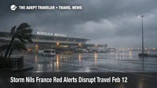
Storm Nils is no longer a planning story for France travelers, it is producing live, localized shutdown risk across southern corridors on Thursday, February 12, 2026. Météo France escalated conditions into red vigilance for a mix of violent wind, flood, and avalanche risk, and utilities and transport operators are reporting realized impacts, including outages and network interruptions. If your trip depends on a single rail link, a long motorway drive, or a tight rail to airport transfer, the practical move is to treat red vigilance areas as conditional no go zones and rebuild your itinerary around alternates that do not rely on exposed segments.
The clearest operational signal for travelers is the red vigilance footprint. Reporting tied to Météo France indicates five departments were placed under red vigilance on February 12, 2026, Aude and Pyrénées Orientales for wind, Gironde and Lot et Garonne for flooding and crues, and Savoie for exceptional avalanche risk. As the day progressed, at least some of the wind related reds were reduced, with updates indicating Aude and Pyrénées Orientales moved back to orange while flood and avalanche reds persisted in Gironde, Lot et Garonne, and Savoie.
At the same time, the storm track is pushing impacts east, not ending them. Météo France notes winds shifting toward the Gulf of Lion and Corsica, with the Aude and Pyrénées Orientales exposed to the strongest gusts, and it flags an avalanche situation described as exceptional in the Alps, with the potential for very large avalanches to reach roads and infrastructure in mountain areas.
Who Is Affected
Travelers moving through southwest rail corridors are among the most exposed, because line safety checks and preventive holds can eliminate the last viable connection of the day. SNCF Réseau implemented preventive stop circulation measures across a wide set of Nouvelle Aquitaine lines, including Bordeaux to Dax, Dax to Hendaye, and several coastal and regional branches, with restart times dependent on inspections after the worst conditions pass. The same bulletin also lists speed limitations on corridors such as Libourne to Bergerac, Coutras to Périgueux, Bordeaux to La Réole, and Pau to Tarbes, which can turn an on paper connection into a misconnect even when trains are technically running.
Rail disruption is also spilling into day of station decisions in the Bordeaux area. Public updates relayed by TER Nouvelle Aquitaine indicate the Bordeaux to Agen axis was interrupted for the day on February 12 because trees on the tracks and wind conditions prevented operation, a pattern that typically forces travelers into crowded replacement services, last minute rebooks, or an overnight reset.
Drivers crossing Atlantic and southwest motorway approaches are exposed to a different failure mode, road restrictions that break the first mile of a travel chain. VINCI Autoroutes warned that orange wind conditions and the storm progression can impact a long list of major routes, including the A10, A62, A63, A64, and others, with additional corridors drawn in as the storm track advances. Even where a highway remains open, the risk for travelers is not only slower driving, it is delayed airport and station access that cascades into missed check in windows and missed departures.
Anyone sleeping in or transiting red vigilance departments should also treat power and communications outages as a compounding disruption. Enedis issued an alert stating it mobilized rapid intervention resources in response to Storm Nils and reiterated downed line safety guidance, which matters for travelers because outages can affect rail power supply, station services, hotel operations, and the ability to receive real time updates.
What Travelers Should Do
If you are starting, ending, or driving through a red vigilance department, use that status as a hard decision trigger to postpone non essential movement, and do not rely on a single corridor plan. For wind and flood red vigilance, Météo France guidance explicitly emphasizes staying home and avoiding car use, and for travelers that translates into delaying discretionary day trips, shifting check out times, and arranging a flexible backup night near your current location rather than trying to force a departure during peak conditions.
Set a concrete rebooking threshold tied to your downstream penalties, not to hope that conditions will improve by afternoon. If your itinerary includes a long haul departure, a cruise embarkation, a prepaid tour start, or separate tickets with tight minimum connection time, rebook as soon as you see your rail segment placed on stop circulation or your route entering a red vigilance area. If you are flexible and staying local, you can wait out short disruptions, but only if you have a realistic alternate to reach your next anchor point without depending on the most exposed lines listed by SNCF Réseau.
Over the next 24 to 72 hours, monitor in a disciplined order and assume the disruption will move, not vanish. Start with Météo France for the evolving wind, flood, and avalanche risk footprint and the expected eastward shift toward the Mediterranean and Corsica. Then confirm operator level status for your exact train number and region, and treat restart time estimates as conditional on inspections and clearance. If you must drive, check concessionaire and local authority traffic updates before departing, because detours and restrictions can change quickly when trees fall on saturated ground.
How It Works
A storm like Nils propagates through the travel system in layers that do not recover at the same speed. The first order effects are physical and immediate, gust thresholds force rail speed limits or stop circulation holds, trees and debris block tracks and secondary roads, and flood risk can trigger local restrictions, all of which can strand travelers away from hubs even if their final destination is not in the worst weather. The second order ripple appears as connection failure, late arrivals into junction stations, missed onward trains, and a fast build of rebooking demand that outpaces capacity once services resume. The third layer is operational drag from outages and inspections, where power and communications issues, plus mandatory line checks before restarting trains, can keep schedules unstable well after winds begin to ease, pushing more travelers into unplanned hotel nights near stations and airports.
For readers who saw the earlier forecast based briefing, the difference now is that decisions should be driven by live red vigilance geography and confirmed operator actions, not generic buffer advice. The prior outlook remains useful for understanding why the storm track creates staggered impacts across regions, and you can reference it here: Storm Nils France Travel Disruptions February 12.
Sources
- Tempête Nils, fortes pluies, crues et avalanches, Météo France
- Vigilance Météo France, Carte de vigilance météorologique sur la France
- Tempête NILS, Mesures préventives sur le réseau ferroviaire de Nouvelle Aquitaine, SNCF Réseau
- Tempête Nils, prudence sur le réseau VINCI Autoroutes
- Alerte tempête Nils, Enedis
- Tempête Nils, plus que 3 départements en vigilance rouge, RTL
- EN DIRECT, tempête Nils, Le Monde