Flight Delays and Airport Impacts: February 17, 2026
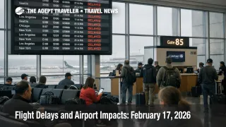
Low clouds and wind are setting up a capacity management day across multiple U.S. hubs, with the FAA flagging low ceilings for Boston Logan International Airport (BOS), New York area airports, Philadelphia International Airport (PHL), and Washington, D.C. area airports, plus wind related slowdown risk across major western hubs. Travelers with connections through those nodes are the most exposed, because even modest arrival rate cuts can trigger gate holds, missed connections, and thinner same day rebooking. The practical move is to treat today as a buffer day, watch for FAA traffic management initiatives, and reroute earlier if your itinerary is built on a tight connection.
The FAA Daily Air Traffic Report calls out low clouds in the Northeast and Washington area, wind across Denver and key West Coast airports, and low clouds with rain in Seattle, which is a combination that tends to compress arrival rates and stretch taxi and gate times.
Who Is Affected
Travelers transiting the Northeast corridor face the highest compounding risk because the region concentrates demand into scheduled banks, and low ceilings often reduce acceptance rates into multiple airports at once. The FAA Command Center planning notes low ceilings as a terminal constraint across Boston, the New York area airspace complex, Philadelphia, and the Washington region, which can translate into metering that starts locally but propagates nationally as aircraft rotations slip.
West Coast and Rockies itineraries are also vulnerable today, especially if your schedule depends on a late day arrival into a wind exposed hub. FAA planning language explicitly evaluates a Denver International Airport (DEN) ground delay program tied to strong west wind and a potential configuration shift, and it signals a later initiative that is probable for San Francisco International Airport (SFO). When those programs trigger, the first order impact is slowed arrivals and airborne holding, and the second order impact is missed evening connections, delayed transcontinental departures, and rebooking pressure that pushes travelers into overnight stays in hub cities.
Seattle Tacoma International Airport (SEA) is a separate weather category today, with low clouds and rain flagged in FAA materials. That matters because low visibility days in Seattle can force spacing increases and arrival rate reductions that ripple into missed Alaska connections, and then into hotel and rental car pickup timing failures for travelers whose arrival is no longer aligned with local inventory cutoffs.
What Travelers Should Do
Start with immediate actions and buffers that match your failure points. If you connect through Boston, New York area airports, Philadelphia, Washington area airports, Denver, San Francisco, or Seattle, pull up your inbound aircraft and watch whether it is being held at its origin under a traffic management initiative, because that is often the earliest signal your flight will not recover. If you have any fixed time ground transfer, bag drop cutoff, cruise embarkation, or prepaid event on the far end, add buffer now rather than hoping the system catches up later.
Use a decision threshold for rebooking versus waiting that is tied to same day optionality. If you are sitting on a connection under 90 minutes through any of the constrained corridors, or you are on separate tickets, treat the first sustained delay trend as a trigger to move earlier or reroute through a different hub while seats still exist. If you are protected on one ticket and you have multiple later departures, waiting can be rational, but the cutoff is when you are down to the last viable same day option, because reaccommodation after that usually becomes an overnight.
Over the next 24 to 72 hours, monitor whether initiatives expand in the Northeast, and whether wind driven programs propagate across the West Coast and Rockies into evening banks. FAA planning also lists several airport construction and operational constraints, and those do not create delays by themselves, but they reduce slack when weather worsens, which is why late day recovery can fail even after conditions improve. For continuity with the prior network pattern, see Flight Delays and Airport Impacts: February 16, 2026. If your biggest risk is terminal processing rather than airside flow, compare against US DHS Shutdown TSA Delays Raise Airport Line Risk.
How It Works
The FAA Command Center manages network flow by matching demand to reduced capacity using tools such as miles in trail restrictions, arrival rate reductions, ground delay programs, and ground stops. The first order effect is straightforward, arrivals are metered into an airport when ceilings, wind, or runway configuration reduce throughput, which shows up as holds at the departure point, longer taxi times, and sometimes airborne holding into the destination.
The second order ripple is where travelers feel the real cost. Aircraft and crews operate in linked rotations, so a delay into a hub pushes the next legs late, compresses connection windows, and creates gate conflicts that keep arrivals on the ramp longer. When multiple regions are constrained on the same day, for example low ceilings in the Northeast plus wind at western hubs, the network has fewer unconstrained alternates to absorb disruptions, and rebooking options shrink faster because later flights were already planned near full. That is also why a localized advisory, like San Francisco arrival delays tied to low ceilings, can quickly turn into coast to coast misconnect risk once transcontinental banks are affected.
For deeper structural context on why capacity management days can persist even when forecasts look modest, see U.S. Air Traffic Control Privatization: Reality Check.