Southwest France Flooding Disrupts Roads and Trains
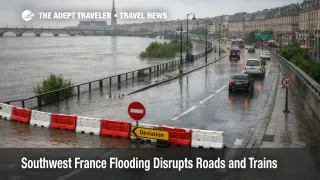
Flood risk and transport disruption are persisting across parts of southwestern France because rivers are still running high on saturated ground after successive storm systems. Travelers who assumed the weather story ended with the last named storm are now running into a different problem, recovery is uneven, and mobility can degrade again when water propagates downstream or when high tides amplify confluence areas. The practical result is a prolonged window of road closures, regional rail delays, and occasional localized service suspensions that can break first mile access into small towns, and can also turn normal transfer times into missed connections.
The core mechanism is hydrology, not headlines. Vigicrues bulletins for the Gironde, Adour, and Dordogne area describe a broad episode that is receding in many sectors, while some downstream segments can still rise or stay unstable, especially where tributaries propagate into larger rivers and where tidal effects matter near confluences. That is why the risk persists after the sky clears, and why the update cadence of the flood monitoring system is a better traveler signal than a single day forecast.
Who Is Affected
Travelers are most exposed when their itinerary depends on one fragile surface link, such as a single regional train to reach a rural stay, a motorway drive parallel to a river corridor, or a timed rail to airport transfer. In flood recovery, the failure mode often flips from slower travel to broken access, meaning you can have a valid ticket and an operating service, but still cannot reliably reach the station, the pickup point, or the lodging on time.
Rail travelers using Nouvelle Aquitaine regional lines, and connections that flow through Bordeaux Saint Jean, face elevated misconnect risk because service patterns can change quickly when infrastructure inspections, water near the right of way, or downstream constraints trigger slow orders and partial suspensions. SNCF has warned travelers in affected zones to check journey status in advance as disruptions continue beyond the peak event.
Drivers face the most direct disruption, because road closures and detours often hit low lying routes first, then funnel traffic onto a limited set of crossings and higher ground corridors. That concentrates congestion outside the flood zone, and it can crowd rail hubs and airport access roads that are otherwise operating, producing second order delay even for travelers who are not sleeping in an impacted area.
Air travelers are affected indirectly through surface access and crew and aircraft positioning. If passengers and crews cannot reach terminals on schedule, short haul flights become more likely to cancel or depart late, and those delays can then push into later banks as aircraft rotations and duty time limits tighten. For travelers, this looks like random cancellations, but it often starts with ground access reliability.
What Travelers Should Do
If your plan involves driving into, or out of, river adjacent areas near Bordeaux, Saintes, Libourne, Dax, or other low lying corridors, build a conservative buffer and treat "open on the map" as non definitive. Use official flood bulletins as a go or no go trigger for same day movement, and avoid committing to last trains, last flights, or late check ins when you have few alternate routes.
Set decision thresholds before you are under pressure. If your trip includes a long haul departure, a cruise or tour start, or separate tickets with tight minimum connection time, rebook or shift dates as soon as you see your corridor remain under elevated flood vigilance for the next monitoring cycle, or if your rail operator indicates disruptions are ongoing. Waiting for a morning of improvement is how travelers get trapped by an afternoon reactivation downstream.
Over the next 24 to 72 hours, monitor in a disciplined order. Start with Météo France for flood and rainfall vigilance context, then use Vigicrues for the specific river segments and their next bulletin timestamp, then check SNCF and regional transport channels for line level service status before you commit to transfers. If the flood signal stays elevated, route through larger hubs with more frequent service, and keep lodging and ticket rules flexible so you can absorb a one night reset without cascading penalties.
Background
Flood disruption in France is rarely confined to one riverbank. First order effects start at the source, rivers overtopping and saturating adjacent infrastructure, which forces road closures, diversions, and rail inspections that reduce capacity. Second order effects then show up at connection points, because detours compress demand into fewer road crossings, and rail travelers who miss one train rebook onto a smaller remaining set of departures, which amplifies crowding and delay at hubs. A third layer hits travel supply, hotels fill in the wrong places when passengers cannot move onward, tours reshuffle when clients cannot reach meeting points, and transport operators become more conservative with cancellations to protect safety and assets.
This is why the recovery window matters more than the initial storm name. In prior southwest France coverage, the operational pattern was that wind and rain phase impacts can transition into multi day flooding and access breaks along the Garonne basin, even as the broader forecast improves. Related context remains useful here, including Storm Nils France Red Alerts Disrupt Travel Feb 12 and Storm Nils Southwest France Flooding Hits Bordeaux Rail. For travelers whose plans intersect the Dordogne and Gironde confluence area, the site's river monitoring explainers can help interpret the tide plus river interaction, see Dordogne River Water Levels Outlook, Week of December 8, 2025.
Sources
- Bulletin de vigilance crues Gironde-Adour-Dordogne (Vigicrues)
- Vigilance Pluie Inondation (Météo France)
- France maintains red flood alert as Storm Pedro hits southwest (Euronews)
- France Severe Weather and Floods (ECHO Daily Flash) (ReliefWeb)
- Tempête NILS, Mesures préventives sur le réseau ferroviaire de Nouvelle Aquitaine (SNCF Réseau)