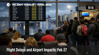
Flight Delays and Airport Impacts: Feb 27
Feb 27 flight delays are shaping up as a multi region reliability day driven by low clouds at Charlotte Douglas International Airport (CLT), the Houston airports, and San Francisco International Airport (SFO), plus thunderstorms that can slow flows in and out of Hartsfield Jackson Atlanta International Airport (ATL), Memphis International Airport (MEM), and Tampa International Airport (TPA). Compared with February 26, 2026, the risk footprint shifts west and south, with Houston and Tampa joining the main constraint set, which increases the odds of missed connections for travelers routing through the Southeast and into Florida. The practical move is to protect connection time and treat afternoon and evening segments as higher risk, even if your origin airport looks fine early.
Feb 27 Flight Delays: What Changed for Travelers
The FAA's daily outlook flags low cloud ceilings as the main limiter at Charlotte, Houston, and San Francisco, and that matters because low ceilings typically reduce arrival rates first, then cascade into departure delays as gates fill and aircraft rotations drift. Thunderstorms around Atlanta, Memphis, and Tampa add a second failure mode, airborne reroutes and flow restrictions that can stretch block times, create missed crew connections, and turn a manageable delay into a late day cancellation risk when aircraft and crews time out.
Operationally, the system signal is not just the weather at a single airport, it is the combined effect of multiple air traffic control centers managing convective weather at the same time, including the Southeast and Gulf regions. When that happens, the most common traveler surprise is that flights look on time in the morning, then degrade quickly once reroutes and spacing programs stack up in the afternoon.
Which Itineraries Face the Most Disruption
Travelers connecting through Atlanta and Charlotte face the highest compounding risk, because those hubs concentrate a lot of onward itineraries, and thunderstorms or low ceilings there can block multiple banks of departures. If your itinerary connects onward to Florida, the exposure rises again, because the FAA operations plan explicitly warns stakeholders to anticipate airborne reroutes due to weather, and it also flags potential late day constraints for the central Florida and Tampa area airports.
Houston exposure is split between William P Hobby Airport (HOU) and George Bush Intercontinental Airport (IAH). Low clouds can cut arrival acceptance rates, and once arrival queues build, departures get delayed as gates stay occupied longer. San Francisco's low cloud pattern tends to create arrival metering that ripples into evening departures up and down the West Coast, even for travelers who never touch SFO but are flying an aircraft that is scheduled to rotate through it.
There is also a Washington, DC friction point worth noticing. The FAA operations plan shows a ground delay program at Ronald Reagan Washington National Airport (DCA) during the day, which can be enough to break tight same day connections in the Northeast and Mid Atlantic, especially when travelers are already being rerouted around thunderstorms.
What Travelers Should Do Now
If you are traveling on February 27, 2026, build buffer time where it actually prevents losses, connections, check in cutoffs, and last mile airport access. For Atlanta, Charlotte, Houston, San Francisco, Tampa, and Memphis itineraries, a safer posture is to avoid short connections, and if you have a tight connection you cannot change, treat your first flight's on time performance as the only thing that matters, because your outbound leg will not wait for you.
The decision threshold is simple. If your first segment is delayed more than about 60 minutes, or if your inbound aircraft is running late before you even leave for the airport, start reworking the itinerary immediately, because same day seats disappear fast during multi region constraint days. Waiting can save money if waivers appear, but rebooking early usually saves the itinerary when hubs are absorbing weather and reroute volume.
Over the next 24 to 72 hours, watch three signals: updated FAA operations plans for ground stops and delay programs, airline app push notifications for route specific waivers, and your aircraft's inbound leg starting in the morning, even for evening departures. If you want continuity with yesterday's pattern and how to read these day over day signals, see Flight Delays and Airport Impacts: Feb 26.
Why the Disruption Spreads Through Travel
Low clouds and thunderstorms degrade the system in different ways, and today has both. Low ceilings reduce how many aircraft per hour can safely arrive, which creates airborne holding or metering, and then pushes delays into departures as gates remain occupied and crews miss scheduled turns. Thunderstorms add route uncertainty, because air traffic must route around cells, and when multiple centers are managing convective weather at once, dispatchers often need extra fuel and longer routings to stay legal and safe.
The FAA's current operations plan makes that mechanism visible. It notes thunderstorm driven impacts across several regions, warns of airborne reroutes with fuel planning implications, and highlights potential Florida ground stop scenarios later in the day. Even when an individual airport is not "closed," these programs reduce throughput, and the second order effect is where travelers lose time and money, missed connections, forced overnight stays near hubs, and thinner rebooking options because the remaining seats are being chased by everyone at once.
For the structural context behind why these constraint days recur and why recovery tails can linger, see U.S. Air Traffic Control Privatization: Reality Check.