Queensland Flood Risk Rises, Tropical Low Watch
Queensland flood travel disruption risk is rising on February 27, 2026, as heavy rain and flooding combine with a strengthening monsoon trough, and the Bureau of Meteorology monitors the Coral Sea for possible tropical low development. The key change versus a single storm day is duration, this is shaping up as a multi day hazard where roads can reopen, then close again, and regional flight schedules can become unreliable as aircraft and crews struggle to reposition. Travelers with self drive segments, remote lodges, liveaboards, or tight connections via Far North Queensland airports should plan for a wider buffer window and be ready to reroute or postpone if warnings escalate.
Queensland Flood Travel Disruption: What Changed
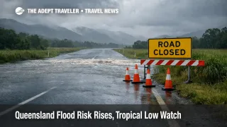
Two things are happening at once. First, flooding and debris are already closing roads in northern districts, including multiple Hinchinbrook Shire roads flagged as closed due to water over road and flash flooding on the Queensland Traffic network reports on February 27, 2026. Second, forecasters are signaling a sustained wet pattern in Far North Queensland and Cape York Peninsula, with the monsoon trough expected to stay active, and a low chance that a forecast low pressure system in the Coral Sea could develop further next week.
For trip planning, the practical takeaway is that you should treat today as the start of a rolling risk window, not a one off inconvenience. If your plan depends on making a single crossing, a single developmental road, or a single regional flight to stay on schedule, your itinerary is exposed to cascading knock on effects if conditions worsen, or if a closure shifts traffic onto fewer alternates.
Which Itineraries Are Most At Risk In North Queensland
The most exposed trips are the ones that cannot absorb a route break. That includes self drive loops that rely on developmental roads in the Gulf Country and Cape corridors, and any out and back plan where the return path depends on the same river crossing staying open. Queensland Traffic's Far North district reports show long term flooding closures on major developmental routes and crossings, which is the classic pattern that isolates towns and forces travelers to either wait it out, or fly around the cut points.
Itineraries routed through smaller airports are also more fragile. When weather deteriorates across a wide area, regional aircraft can get stuck out of position, and even when the runway is usable, services can be delayed or canceled because the inbound aircraft never arrives. Travelers connecting through hubs like Cairns Airport and Townsville Airport, and onward to smaller fields serving the Torres Strait and Cape communities, should assume higher variance in departure times during the active trough window described in current reporting.
If you are already watching inland disruption patterns elsewhere in Australia, it is worth reading Australia Inland Flooding Closes East West Rail Line as a reminder of how quickly corridor breaks turn into supply and schedule issues. The mechanism is similar even when the asset changes from rail to road and air, once a trunk route is down, everything concentrates onto fewer options, and the odds of a missed connection rise.
What Travelers Should Do Now
Start by switching your decision tools from general forecasts to operational feeds. Check the Bureau of Meteorology for warnings and cyclone outlook updates, then check QLD Traffic for the specific roads you will drive, including developmental roads and named crossings, and do it at the start of the day and again before you commit to a long segment. The QLD Traffic district reports are already listing closures for flooding and debris in Far North and northern districts on February 27, 2026, which is exactly the kind of detail that should override a plan built on best case driving times.
Use a clear postpone threshold if your route has no robust alternate. A good operational trigger is any segment where the safe detour adds multiple hours and pushes you into night driving, or where the next fuel, food, or lodging stop depends on one crossing that is trending worse on official updates. If you are booked on reef, rainforest, or outback tours with fixed departure times, contact the operator early and ask what their weather hold rules are, and whether they can move you to a safer day without penalty, because the rescheduling crunch tends to hit once everyone tries to compress into the same clear window.
For flights, avoid tight same day connections in the far north during the active trough period, and treat early morning departures as less risky than late afternoon hops that depend on the day staying stable. If you must travel on a specific day, pick routings with more frequencies and larger aircraft where possible, because they are easier to recover when one sector cancels. Keep ground transfers flexible, and assume airport access roads can run slower than normal in heavy rain.
Why The Monsoon Trough Creates Multi Day Disruption
The monsoon trough matters because it is not just rain, it is a broad scale setup that can keep feeding moisture and storm activity into the same region for days. That increases the odds of repeat closures and rolling isolation, since rivers and catchments do not reset overnight, and debris and pavement damage often linger even after water levels drop. ABC reporting this week has already highlighted the pattern of road closures and community isolation risks across northern Queensland during heavy rain periods, and Queensland Traffic's live reports show how that translates into discrete closures at named roads and crossings.
The second order effect is that disruptions spread beyond the flooded spot. When a key road closes, traffic concentrates onto fewer routes, recovery crews and supplies take longer to reach affected towns, and tour operators lose the ability to reposition guides, vehicles, and boats on time. In parallel, aviation disruptions become more likely when multiple airports sit under the same weather system, because aircraft rotation options shrink, and delays stack. The Bureau of Meteorology's cyclone outlook and current monsoon trough messaging are important here not because a cyclone is guaranteed, but because even the possibility of tropical low organization can extend the risk window and raise confidence that the wet pattern persists.
Sources
- Department of Transport and Main Roads, QLD Traffic, Northern District Road Report
- Department of Transport and Main Roads, QLD Traffic, Far North District Road Report
- Department of Transport and Main Roads, QLD Traffic, Far North List View
- Bureau of Meteorology, Tropical Cyclone 7 Day Forecast
- ABC News, Central Australia tropical low expected to linger for days as floods impact Queensland towns (February 26, 2026)
- ABC News, North Queensland on high alert as heavy rain continues (February 21, 2026)