North Queensland Tropical Low Risk Grows for Islands
North Queensland tropical low risk is rising into early March 2026, and that matters most for travelers who are planning reef days, island hops, and tight same day connections along the coast. Australian forecasters are watching a developing Coral Sea low with uncertainty around where it tracks later in the week, and they are also flagging a wetter monsoon pattern building across North Queensland. The practical consequence is more last minute cancellations for reef tours and ferries, plus higher variance for regional flights when weather and wind warnings overlap with already saturated catchments.
North Queensland Tropical Low Risk: What Changed
The key update is timing and organization, not just "it is the wet season." A tropical low is developing in the Coral Sea, and ABC reporting on March 1, 2026, notes a moderate chance of cyclone development later in the week, with uncertainty about where the system goes beyond midweek. At the same time, the Bureau of Meteorology has been signaling above average rainfall potential across much of Queensland into mid March, with flood warnings already in play across parts of the state because catchments are full and soils are wet.
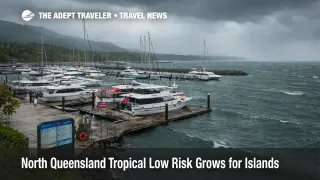
For coastal and island travel, wind and sea state often become the trip breaker even when rainfall totals look manageable on paper. Bureau marine forecasts show Strong Wind Warnings for multiple coastal zones, with elevated winds and seas on routes and offshore waters that reef operators and ferry services rely on. That combination, a developing low plus an active monsoon trough pattern plus strong winds, widens the disruption window from a single bad afternoon into a multi day planning problem.
Which Island And Reef Itineraries Are Most Exposed
The most exposed plans are the ones that stack two fragile links on the same day. If a traveler is flying into the region and then connecting to an island by ferry, or booking a liveaboard check in that depends on being at the marina at a fixed time, one delayed flight or one suspended crossing can break the whole chain. This is especially true when operators cancel for safety and logistics reasons, because they cannot guarantee return crossings, tender operations, or safe anchoring in deteriorating conditions.
Trips that look "close together" on a map also fail in a predictable way during active trough weeks. When one segment cancels, everyone tries to rebook into the same smaller pool of later sailings and "good weather" tour slots, and the rebooking pileup becomes its own constraint. The second order effect is accommodation compression, travelers end up stuck on the wrong side of a canceled crossing, and inventory tightens quickly in gateway cities because people cannot move when they planned.
Self drive and regional touring are exposed differently. When flood warnings persist and catchments are full, closures can reopen and then close again, and detours can become long enough to force night driving or missed check in windows. Anyone combining inland roads with coastal ferries should treat the next week as a rolling risk window, not a normal schedule week with a few showers.
What Travelers Should Do Now
Travelers with reef tours, ferry legs, or island stays should stop planning around "average conditions" and start planning around decision thresholds. The simplest threshold is this, if an island connection is required to avoid losing a night of lodging or a nonrefundable tour, do not put that connection on the same day as your arrival flight. Move the flight earlier by at least one calendar day, or book a mainland buffer night that you can actually use if the crossing pauses. The tradeoff is extra cost versus protecting the itinerary, and during active trough periods the protection usually wins.
For tours, call the operator before the weather deteriorates, not after. Ask how they handle wind cancellations, whether they rebook without penalty, and whether they refund or only offer credit when marine warnings are issued. Then align your schedule so you have at least one alternate day in the same region, because the most common failure mode is "tour canceled, no seats left on the next calm day."
For flights, assume higher delay variance on the coastal airports most used as gateways, and avoid tight onward connections and late day last flights. When weather and winds are the constraint, recovery often depends on aircraft rotation and crew legality, and that is why disruptions can spill into the next day even after conditions improve. If a trip is time critical, choose routings with more daily frequencies and earlier departures, and treat same day island boarding as a risk decision, not a default plan.
If this is part of a broader Queensland weather week for you, it is also worth reviewing the earlier update, Queensland Flood Risk Rises, Tropical Low Watch, because the mechanism is the same, once roads, boats, and regional aircraft are all operating inside the same weather envelope, the system runs out of slack quickly.
Why A Developing Low Can Break Island Schedules
A developing tropical low matters because it changes both confidence and duration. Even when the exact track is uncertain, the presence of an organizing system can keep moisture and instability feeding into the same coastal corridor, which raises the odds of repeated thunderstorms, overnight rainfall peaks, and stronger winds over coastal waters. For travelers, this means disruptions are more likely to arrive as rolling constraints, not a single dramatic event, and that is why buffers and sequencing decisions matter more than obsessing over the exact hourly forecast.
Marine conditions are the practical transmission mechanism for island plans. Stronger sustained winds push up sea state, restrict tender operations, and increase the likelihood that operators cancel for safety rather than "try to run." The first order impact is a canceled crossing or a canceled reef day. The second order impact is a rebooking logjam, stranded luggage, and accommodation churn as travelers are forced to stay put while the system resets.
For international visitors layering this into a longer Australia trip, keep the paperwork side boring and stable so the weather side can be flexible. Australia Entry Requirements For Tourists 2025 2026 is the evergreen reference point on visas and entry basics, so you are not dealing with documentation surprises while you are also juggling weather changes.