Oahu Flooding Hits North Shore Travel Plans
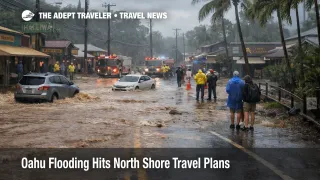
Oahu flooding travel risk jumped sharply on March 20, 2026, when severe rain triggered evacuations across the North Shore, emergency warnings tied to possible failure at Wahiawa Dam, and major flooding in Waialua and Haleiwa. The National Weather Service said flash flooding had become life threatening in northern Oahu, and emergency management warnings were serious enough to trigger sirens and evacuation messaging downstream of the dam. For visitors, this is not a generic rainy day story. It is a fast moving ground access, lodging, and excursion disruption centered on the North Shore, with additional rain still in the forecast through Sunday, March 22.
The immediate operational problem is that the travel system is being constrained from the ground up. Roads have been closing, shelters have had to move because of flooding, and rescue operations have been ongoing as officials search inundated areas and move stranded residents to safety. AP reported more than 230 rescues, no confirmed deaths as of the latest reporting, and about 10 people treated for hypothermia, while officials warned that damage could exceed $1 billion.
For travelers already staying on the North Shore, especially in Waialua, Haleiwa, and nearby communities, the main issue is not just water on the road. It is that access can change faster than hotel, rental car, or tour platforms update, which raises the odds of getting stuck in place, missing transfers, or arriving after a property has lost normal operations. In an earlier Adept Traveler article, Hurricane Kiko: Hawaii port status, cruise and flight plans, coastal weather risk in Hawaii was more about timing and buffers. This event is more severe because it has produced actual evacuations, active rescues, and dam failure warnings.
Which North Shore Travelers Face the Most Disruption
Travelers with lodging, surf lessons, shark tours, horseback rides, scenic drives, or beach stops on Oahu's North Shore face the highest disruption risk. That includes visitors driving between central Oahu and the North Shore, anyone relying on flexible road access to vacation rentals, and travelers planning short windows between check out, sightseeing, and evening flights. The Hawaii Department of Transportation reported multiple closures and restrictions, including Kamehameha Highway flooding closures on March 20, and as of early March 21 it was still reporting closures on Farrington Highway and lane restrictions on Kamehameha Highway.
The exposure is not evenly spread across Hawaii. This is primarily a North Shore and broader Oahu ground transport problem, not a confirmed statewide airport shutdown. That distinction matters. A traveler staying in Waikiki with no island drive planned faces a different risk profile than someone sleeping in Haleiwa and flying out the same day. Oahu visitors should judge their itinerary by road dependence, not by whether Honolulu looks dry at the moment. Hawaii's own destination guidance notes that weather can vary significantly across short distances, which is unusually relevant in this event because one area's passable conditions do not mean the island's leisure corridors are functioning normally.
Visitors with the least flexibility are those in vacation rentals or small properties in affected communities, because they may have less robust relocation help than guests in large resort zones. Families with children, travelers with pets, and visitors on tightly timed island hopping plans also face higher friction if road closures force reroutes or overnight changes.
What Travelers Should Do Now
If you are booked on Oahu's North Shore through Sunday, March 22, the safest move is to strip nonessential movement out of your plan. Do not drive into flood warning areas for sightseeing, surf checks, or meals just because photos on social media look manageable. Conditions around flooding and dam related warnings can change faster than a tourism itinerary can absorb. The next decision point is simple, if your lodging, tour, or route depends on Waialua, Haleiwa, Farrington Highway, or Kamehameha Highway access, contact the provider now and ask whether they are operating today, not whether they hope to operate later.
For travelers due to check in on the North Shore, rebook before you are on the road if the property cannot confirm safe access. Waiting may preserve optionality on paper, but early relocation can save the itinerary. Travelers staying elsewhere on Oahu should keep extra buffer for any cross island transfer and avoid tight same day links between North Shore activities and evening departures. For broader trip planning, Hawaii - Travel News and Guides from The Adept Traveler is useful background, but this weekend's problem is acute weather and road access, not normal island microclimate variation.
Over the next 24 to 72 hours, watch three signals. First, whether the National Weather Service extends or upgrades flood warnings tied to the dam and North Shore streams. Second, whether HDOT reports more reopened roads or new closures. Third, whether local authorities shift from rescue and evacuation toward reentry guidance. Until those signals improve, Oahu flooding travel should be treated as a live disruption, not a past storm cleanup story.
Why The Disruption Is Still Expanding
The mechanism matters here. Oahu had already been saturated by an earlier storm, and officials were monitoring Wahiawa Dam levels before the latest round of rain arrived. That means the second storm did not need to be the strongest one to cause serious new damage. When saturated ground, swollen streams, and constrained drainage combine with renewed rainfall, roads fail first, then evacuation logistics tighten, then lodging, tours, and local services start to break around them.
The dam warning is especially significant because it changes the consequence range. A standard flood event already disrupts movement and access. A possible dam failure warning adds a downstream risk that can force broader evacuation zones and a more urgent official posture. The National Weather Service warning explicitly referenced flash flooding from the imminent failure of Wahiawa Dam along the Kaukonahua Stream corridor, which is why this event cannot be read as routine tropical downpour disruption.
What happens next depends on rainfall totals, drainage, and infrastructure performance over the weekend. AP reported forecasts for another 6 to 8 inches in coming days in some areas, and the statewide flood watch remains in effect through Sunday afternoon. That means even travelers outside the worst hit North Shore zones should assume uneven conditions, slower road recovery, and continued operational caution. For now, Oahu flooding travel decisions should be driven by verified road status and local warnings, not by original vacation plans.
Sources
- Flash Flood Warning, National Weather Service Honolulu
- Active Watches, Warnings and Advisories for Hawaii, National Weather Service Honolulu
- Weather Related Traffic Alerts, Hawaii Department of Transportation
- Hawaii's worst flooding in 20 years threatens dam, prompts evacuations as more rain looms, AP News
- 230 people are rescued as flash flooding hits Hawaii and officials warn 120-year-old dam could fail, AP News