Canary Islands Weather Alerts Still Threaten Access
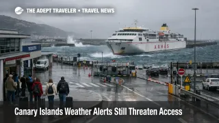
Canary Islands weather alerts are still a live planning problem for travelers moving around the archipelago, but the risk has shifted from a broad storm headline to an island by island timing issue. On March 22, the Canary Islands government kept rain alerts in place for El Hierro, La Palma, La Gomera, Tenerife, and Gran Canaria, kept Fuerteventura and Lanzarote under rain prealert, and moved the whole archipelago into coastal and wind prealerts from noon. The same official page showed the wind and coastal prealerts due to end at 12:00 p.m. on March 23, 2026, which means the most fragile window is Sunday into Monday morning rather than the whole week. Travelers with ferries, mountain drives, beach or cliffside plans, and tight airport transfers should still build extra buffer before moving between islands.
Canary Islands Weather Alerts: What Changed
What changed is not just that bad weather lingered. It is that the official alert stack remained layered across multiple hazards after several days of disruption. The March 22 emergency update kept rainfall at alert level on the western islands plus Gran Canaria, kept the two eastern islands at rain prealert, and added a coastal prealert for all islands. Separate emergency notices already in force also kept landslide risk and flood related alerts higher on El Hierro, La Palma, La Gomera, Tenerife, and Gran Canaria, with Fuerteventura and Lanzarote still under lower level flood prealert. AEMET also continued to show active weather warnings in parts of the Canary Islands on March 22, including rainfall warnings in parts of Gran Canaria and La Palma, while its marine forecast pointed to rougher seas and reduced visibility around Gran Canaria.
That keeps the situation in the meaningful disruption category for island logistics, even without a published archipelago wide airport shutdown. First order, ferries, exposed coastal roads, higher elevation routes, and outdoor excursions remain less reliable. Second order, the real trip damage shows up when a delayed ferry or slower road transfer breaks an onward flight, hotel check in, car hire pickup, or inter island day tour that was built on a narrow margin. In an earlier Adept Traveler article, Canary Islands Storm Alerts Hit Ferries March 18 tracked the earlier escalation. The new development is that March 22 kept enough of the official warning structure in place to make Monday morning movements the next key decision point.
Which Islands and Transfer Chains Face the Most Risk
The highest exposure is still on the islands carrying the heavier alert mix, El Hierro, La Palma, La Gomera, Tenerife, and Gran Canaria. Those islands remained under rain alert on March 22, while the entire archipelago also moved under coastal prealert. For travelers, that makes ferry dependent itineraries, mountain or ravine roads, and airport runs that depend on a long cross island drive the most fragile combinations. La Palma, La Gomera, and Tenerife also remain more exposed to the landslide and flood overlay already posted by the regional emergency service, which matters for scenic drives, trail access, and any hotel transfer that depends on steeper terrain rather than short urban runs.
Fuerteventura and Lanzarote sit in a different bucket. They were not in the higher rain alert tier on March 22, but they still remained under rain prealert and joined the archipelago wide coastal and wind prealerts. That usually translates into a lower chance of a full day breakdown, but a higher chance of annoying failures at the edges, rougher port conditions, slower pickups, and more variable beach or boat plans. Travelers connecting from those islands into Tenerife or Gran Canaria should pay attention because the weakest link is often not the destination airport itself, but the inbound ferry, the airport transfer, or the missed check in window that follows.
What Travelers Should Do Before Moving Between Islands
Travelers should treat March 23, 2026 before noon local time as the key decision window. If your trip depends on a ferry, a mountain road, or a long airport transfer, build more slack into the chain now rather than assuming the situation has normalized because the worst headlines have passed. The safest play is to avoid back to back commitments, especially a same day ferry to flight handoff, a long cross island drive before departure, or an excursion that ends close to a check in cutoff.
Rebook or simplify the plan if you are relying on the western islands, higher terrain, or an exposed coastal leg. Wait and monitor if your movement is on Lanzarote or Fuerteventura and can slide later in the day, because the official page already shows the wind and coastal prealerts scheduled to end at noon on March 23. That end time is not a guarantee of smooth recovery, but it is the first meaningful threshold showing whether the system is moving back toward normal timing.
Before any inter island move, check the Canary Islands emergency alerts page from the regional government, the AEMET warning map, and AEMET's coastal marine forecast, then confirm the status page or direct message from your airline or ferry operator. For basic trip context on the busiest island in this weather pattern, see Tenerife, Canary Islands, Spain - Travel News and Guides from The Adept Traveler.
Why the Friction Continues, and What Happens Next
The mechanism is straightforward. The Canary Islands do not need a full transport shutdown to produce meaningful traveler friction. When rain, coastal conditions, wind, flood risk, and landslide risk overlap across several islands, operators can still run much of the system while reliability falls at exactly the points travelers tend to compress, ports, scenic roads, pickup windows, and pre flight ground transfers. That is why a weather event that looks manageable on paper can still break itineraries in practice.
What happens next depends on whether the scheduled March 23 end time for the wind and coastal prealerts is allowed to stand, and whether AEMET warnings continue to contract rather than shift to new zones. If those official signals improve, the main problem becomes backlog and timing drift, not outright access loss. If they are extended again, then ferries, exposed drives, and tightly built island hopping itineraries remain the first plans to cut or rework. For now, travelers should assume the Canary Islands are still navigable, but not on zero buffer logic.