Canary Islands Storm Alerts Hit Ferries March 18
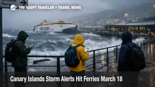
Canary Islands storm alerts moved from forecast risk to active operations risk on March 18, 2026. The Canary Islands government activated wind alerts for El Hierro, La Palma, La Gomera, Tenerife, and Gran Canaria from 600 a.m., put Lanzarote and Fuerteventura under wind prealert, activated a coastal alert for the whole archipelago from 300 p.m., and also put the whole region under prealerts for rain, thunderstorms, and flood risk. What changed since routine bad weather coverage is the official escalation across multiple hazard layers at once, which makes island transfers, exposed drives, coastal promenades, and outdoor plans less reliable even before a broad airport shutdown picture exists. Travelers with ferries, self drive mountain routes, cliffside walks, beach clubs, or cruise shore time should treat March 18 into March 20 as a live decision window, not a normal weather inconvenience.
The practical issue is not just rain. The government says combined northwest seas of 4 to 5 meters may produce isolated waves up to double that height, while the Thursday pattern shifts more southwest and can hit coasts that are usually more sheltered. AEMET has also warned of strong wind, heavy rain, rough seas, and locally persistent precipitation in the Canary Islands, which is why this matters more for island logistics than for a simple pool day decision.
Canary Islands Storm Alerts: What Changed For Travelers
The highest immediate exposure is on the western islands and on north and west facing coasts. The Canary Islands government specifically placed El Hierro, La Palma, La Gomera, Tenerife, and Gran Canaria under wind alert, and said coastal impacts on Wednesday would hit the northwest and north of El Hierro, the west, north, and northeast of La Palma, the west and north of La Gomera and Tenerife, the north and northwest of Gran Canaria, and west and north facing coasts of Fuerteventura and Lanzarote. On Thursday, the swell direction becomes more southwest, which expands risk to coasts that are not usually the first to take the hit.
For travelers, that means the most fragile plans are the ones that chain several exposed pieces together. A same day ferry plus flight, a hotel checkout plus mountain drive, or a cruise call plus independent coastal excursion can all fail before an airport itself shows major cancellations. That is the real change here. The travel system can become unreliable one layer at a time. Ferry boarding can slow or suspend, road access times can stretch, parks or trails can close, and excursions can be pulled before the aviation side shows a clean go or no go signal. Travelers looking for a comparison in how weather can knock out island mobility should see Bermuda Ferry Services Suspended, Island Transfers Feb 1 and Malta Red Wind Warning To Disrupt Gozo Ferries.
Tenerife deserves extra attention because both the coastal and high ground exposures are broad. The government says the main wind impact there includes northwest summits, Las Cañadas, Teide, Izaña, the Anaga heights, and even parts of the Santa Cruz and El Rosario coast. That is a meaningful split for visitors, because a resort stay in the south can remain operational while Teide access, north coast viewpoints, or exposed urban seafront plans become a bad bet.
Which Itineraries Are Most At Risk
The most exposed travelers are not necessarily the ones in the worst weather. They are the ones with the least slack. If you are moving between islands, connecting a ferry or long road transfer to a flight, or depending on one outdoor day to make the trip work, you are in the highest risk group. Cruise passengers on short port calls are also exposed because rough seas, long swell periods, and changing coastal orientation can force local changes even when the wider island remains open.
Self drive itineraries are next. The government has already flagged wind exposure in summit zones, higher mid elevations, and coastal stretches where wind acceleration is common. That matters because mountain roads, exposed bends, and access routes to scenic viewpoints can become uncomfortable or restricted before broad urban mobility breaks down. Hikers and outdoor travelers should assume that north and west facing trails, cliff walks, and any plan tied to Teide or other elevated terrain is more vulnerable than resort or city based indoor plans. For basic destination context, see Tenerife, Canary Islands - Travel News and Guides from The Adept Traveler.
Resort guests are not immune, but their risk is different. The first order effect is usually canceled outdoor programming, closed beach access points, delayed excursion coaches, and more pressure on indoor amenities once everyone pivots at the same time. The second order effect comes after weather improves, when excursion backlogs and rebooked inter island moves create a messy recovery day rather than a clean restart.
What Travelers Should Do Now
Start by protecting hard deadlines. If you have a flight, cruise embarkation, or fixed handoff between islands in the next 24 hours, move earlier where you still can, or position the night before rather than trusting a same day ferry or exposed drive. For March 18 and March 19, the safest threshold is simple, do not rely on a sea crossing or mountain access road as the only path to a nonrefundable departure.
For flexible leisure plans, split your day into safe and conditional pieces. City museums, hotel based activities, and sheltered town plans can remain viable while beaches, promenades, natural pools, boat tours, and ridge or summit outings become no go items. If your hotel or operator has not canceled yet, that does not mean conditions will hold. In coastal alert periods, the operational cut can happen quickly once swell angle, high tide, and wind line up.
Over the next 24 to 72 hours, monitor three signals. First, whether ferry operators and local excursion companies switch from advisory language to cancellations or amended schedules. Second, whether Tenerife or other island authorities publish road, trail, or park access restrictions, especially for Teide and exposed natural areas. Third, whether airport status changes move from routine weather caution to repeated delays on specific island routes. No regionwide airport closure order was visible in the official alerts I reviewed, so the correct read right now is uneven disruption risk, not systemwide shutdown.
Why The Disruption Spreads Beyond The Beach
This weather setup is operationally awkward because the hazards stack rather than substitute. Wind affects summit roads, exposed airport approaches, and open deck ferry operations. Heavy rain and locally persistent precipitation raise runoff and localized flooding risk. Rough seas hit ports, coastal roads, promenades, natural pools, and boat based excursions. Then the tide cycle adds a second timing layer, because the government flagged very high tide coefficients on Wednesday, Thursday, and Friday, with long equinoctial tides that can amplify overtopping and coastal spray problems around peak water.
That combination is why a traveler can see a normal looking hotel lobby while the actual trip logic outside is breaking down. Airports may stay open but access becomes slower. Ferries may run but lose punctuality. Beaches may not be formally closed at first, but promenades and seafront access points can become unsafe. Teide or other outdoor zones may be technically reachable for part of the day, then restricted as wind, rain, or snow conditions change. In other words, the failure mode is uneven reliability, which is harder for travelers than a clean blanket shutdown because it tempts people into tight plans that no longer have enough margin.
What would show stabilization? A downgrade of coastal and wind alerts, fewer island specific restrictions, and operators returning to normal frequency language instead of cautionary or weather conditional wording. What would show escalation? Confirmed ferry suspensions, Teide or natural area access closures, repeated airport disruptions on inter island flights, or local authority orders against coastal access. Until those signals resolve, the right posture is conservative timing, simpler day plans, and no same day dependence on exposed transfers.
Sources
- Alerta Vientos y Fenómenos Costeros y Prealerta Inundaciones Costeras, Tormentas y Lluvias
- El Gobierno de Canarias declara la situación de alerta por viento en las islas occidentales y Gran Canaria
- El Gobierno declara la situación de alerta por fenómenos costeros en Canarias
- AEMET Canary Islands weather warnings
- Tenerife ON Updates and News
- Gran Canaria Airport