March 24 Airport Weather Delays Hit Orlando, Houston
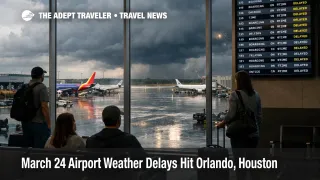
March 24 airport weather delays have become the main new FAA watch item for U.S. flyers after a run of coverage dominated by checkpoint strain and New York recovery. The Federal Aviation Administration said on Tuesday, March 24, 2026, that thunderstorms could affect Orlando International Airport (MCO), while low clouds could affect George Bush Intercontinental Airport (IAH), William P. Hobby Airport (HOU), Seattle, Tacoma International Airport (SEA), Los Angeles International Airport (LAX), and San Diego International Airport (SAN). For travelers, that shifts the same day risk toward afternoon Florida flying, Houston connections, and West Coast arrival banks that depend on normal spacing and quick recovery.
March 24 Airport Weather Delays: What Changed
The practical change is not that the whole U.S. system is breaking at once. It is that the FAA's March 24 planning view narrowed into a smaller set of weather pressure points. The daily air traffic report flagged central Florida thunderstorms and low cloud risk in Houston, Seattle, and southern California, while the operations plan separately listed central Florida thunderstorms and low ceilings along the Seattle and southern California flow corridors. The same operations plan also showed no staffing triggers at that point, which helps separate today's weather map from the checkpoint and shutdown strain that shaped many earlier alerts.
That makes March 24 a more conditional disruption day than a confirmed nationwide slowdown. Flights can still operate normally for long stretches, then deteriorate quickly if convective weather builds around Orlando or if low ceilings reduce throughput at arrival airports that already run tight schedules. In an earlier Adept Traveler article, Flight Delays and Airport Impacts: March 24, the focus was that the national risk picture had narrowed. The new traveler problem is deciding which itineraries can survive that narrower map, and which ones cannot.
Which Travelers and Routes Face the Most Risk
Orlando passengers are the clearest weather exposed group because central Florida thunderstorms can hit a leisure heavy airport where same day trips often carry little slack. The most fragile itineraries are late afternoon and evening departures, inbound flights feeding cruise or theme park transfers, and connecting routings that depend on one clean handoff rather than multiple backup options. The first order effect is a delayed departure or arrival bank. The second order effect is weaker aircraft rotation later in the day, which can break the final leg of a trip even after the storm itself moves off.
Houston travelers are exposed in a different way. Low clouds do not carry the same stop start thunderstorm pattern as Orlando, but they can still compress arrival rates and stretch connection margins at IAH and HOU. That becomes more serious because Houston was already dealing with screening strain on March 23. In an earlier Adept Traveler article, Houston TSA Delays Hit IAH and Hobby on March 23, the problem was checkpoint access and long waits. On March 24, some passengers face a stacked risk where the trip can fail either at security or in the air traffic flow.
Seattle and southern California sit in the watch category rather than the confirmed meltdown category. The FAA outlook names Seattle and southern California for low clouds, and the operations plan specifically points to Seattle and southern California low ceilings as terminal constraints. For travelers, that matters most on transcontinental arrivals, short West Coast turns, and routes where a late inbound aircraft becomes the next departure a gate or crew is waiting on.
What Travelers Should Do Before Assuming Same Day Recovery
Travelers should treat nonstop flights and early departures as safer than tight connections and late day banks. If you are flying through Orlando, keep the trip as booked if you are on an early nonstop or have a large connection cushion. Start pricing backup options if your itinerary depends on a late connection, a final flight into a smaller city, or a timed handoff to a cruise, resort, rental car, or event. The main decision point is not whether the airport is open. It is whether your schedule still has enough slack after the first weather slowdown.
Houston travelers should separate screening risk from flight risk. Leave extra time for the airport even if your airline app still shows the flight on time, especially at IAH. West Coast travelers should watch for deteriorating arrival spacing rather than waiting for a dramatic cancellation wave. If your carrier starts extending estimated arrival times, swapping aircraft, or moving gates repeatedly, that is often the signal that the day is sliding away from a clean same day recovery.
The best monitor points are the airline app, FAA status pages, and whether the airport on your itinerary begins showing ground delay programs or broader flow controls. Rebook earlier if your trip purpose is rigid, such as a cruise embarkation, a wedding, a same day meeting, or the last usable connection of the night. Wait longer if you have a nonstop, flexible arrival timing, and multiple later options on the same carrier.
How the Weather Risk Can Spread Through the Network
Weather on a map does not need to be severe everywhere to create a broader travel problem. A thunderstorm program in Orlando can delay an inbound aircraft, which then departs late for another city, which then leaves less margin for the next crew and gate turn. Low ceilings work differently, but the result can still be similar. They reduce how efficiently an airport handles arrivals and departures, which slows the flow without necessarily creating a dramatic closure headline.
What happens next on March 24 depends on whether the FAA's conditional items stay conditional. If Orlando storms build and linger, or if low ceilings in Seattle and southern California cut throughput for longer than planned, March 24 airport weather delays can broaden into a later afternoon and evening network problem. If the weather remains manageable, the day is more likely to finish as a localized reliability hit rather than another national disruption cycle. Travelers should not assume same day recovery until their specific origin, hub, and final segment still line up after midday, because March 24 airport weather delays are most dangerous when they look small early and then consume the remaining slack.