NOAA DAFS Aviation Forecast Upgrade Starts March 30
National Cceanic and Atmospheric Administration (NOAA) Domestic Aviation Forcast System (DAFS) aviation forecasts are now live after the National Weather Service implemented the Domestic Aviation Forecast System on March 30, 2026, replacing older coarser guidance for key in flight hazards. The main traveler consequence is indirect but real, airlines, dispatchers, and the FAA now have more detailed turbulence and icing guidance when short term U.S. weather changes quickly. That should help flight planning around thunderstorm growth, icing layers, and rough air, though it does not mean passengers will suddenly see fewer delays on every bad weather day. Travelers should treat this as a systems upgrade that may improve tactical routing and safety margins over time, not as a promise of smooth operations.
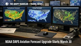
NOAA DAFS Aviation Forecasts: What Changed
What changed on March 30 is that NOAA's operational aviation weather stack moved to DAFS v1.0, an integrated forecast system built from the High Resolution Rapid Refresh model. The official service notice says the system now produces 3 kilometer inflight icing and graphical turbulence guidance, with hourly forecast cycles over the contiguous United States and added science upgrades in both products. NOAA's public rollout described the new system as producing more detailed forecasts of evolving turbulence and icing, the kinds of hazards that most often force pilots and dispatchers to route around rough air, storms, and freezing layers.
That is a meaningful technical step because the older guidance was based on hourly numerical weather models with a coarser horizontal grid. NOAA says the new system is based on HRRR, its hourly updated 3 kilometer model, and the March 23 service change notice says DAFS replaces prior RAP based 13 kilometer turbulence and icing products with newer 3 kilometer versions. In plain language, this gives forecasters and flight planners a tighter map of where hazardous air may develop and how it may move during the next several hours.
Which Travelers Benefit Most From the Upgrade
The biggest direct benefit goes first to dispatchers, air traffic managers, meteorologists, and flight crews. They are the people who use turbulence and icing guidance to decide whether an aircraft should stay on its planned track, climb, descend, deviate, or carry more route flexibility. Passengers feel the effect one step later, especially on domestic flights crossing active spring weather, mountain wave zones, or freezing layers where forecast precision matters most.
The most likely visible traveler benefit is not that storms disappear from the system. It is that the system may get better at seeing dangerous air early enough to support cleaner route choices. On some days that could mean fewer avoidable encounters with rough air, more accurate expectations about where icing risk is concentrated, and better odds that weather restrictions are targeted rather than broader than necessary. On other days, the practical outcome may still be delays, reroutes, and longer flight times, because the safest decision can still be to avoid a hazard rather than push through it. Travelers who want a current operating day example of how weather risk moves through the network can read Flight Delays and Airport Impacts: March 31.
What Travelers Should Do Now
Travelers do not need to take any special compliance step because this is not a document rule, airport fee change, or airline policy change. The useful move is to understand what this upgrade can and cannot do. It can improve the quality of short range hazard guidance that professionals use inside the system. It cannot eliminate storms, prevent every misconnect, or stop the FAA from slowing traffic when conditions still make the airspace less efficient.
For people flying across active weather corridors, the decision threshold stays familiar. Protect short connections when thunderstorms, mountain turbulence, or icing conditions are in the forecast, because better forecasting does not remove the operational need to route around those hazards. Watch inbound aircraft, not just your own departure time, and expect the cleanest benefit from DAFS to show up first in planning quality and safety support, not in dramatic headline level schedule improvements. For broader structural context on why localized constraints can still spread through the network, see U.S. Air Traffic Control Privatization: Reality Check.
Why the New Forecast System Matters Next
The mechanism here is straightforward. HRRR updates hourly on a 3 kilometer grid, and NOAA says it assimilates radar data every 15 minutes over a one hour period. That matters in aviation because turbulence and icing risk often changes fast around growing convection, mountain waves, precipitation bands, and rapidly evolving cloud structures. If the underlying model sees those features more clearly and updates them more often, the hazard guidance built on top of that model should be more useful for real time routing and risk avoidance.
The official notice also makes clear that this is not just a cosmetic product rename. DAFS implementation followed FAA and NTSB safety recommendations, adds new turbulence diagnostics, and expands how the system distinguishes among boundary layer, tropospheric, and stratospheric conditions. That suggests NOAA and FAA are trying to improve not only forecast resolution, but also the way aviation hazards are characterized inside the operational forecast chain. The next thing worth watching is whether airlines, dispatch tools, and forecasters report cleaner tactical decision making during spring and summer convective season, when fast changing U.S. weather can turn minor forecast differences into meaningful routing and passenger comfort outcomes.