Chiapas Route Warning Reshapes San Cristóbal to Palenque Travel
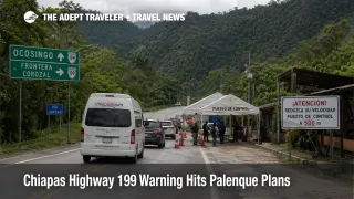
The Chiapas Highway 199 warning is not just another generic Mexico security note, it changes one of southern Mexico's most common overland travel patterns. The U.K. Foreign, Commonwealth and Development Office advises against all but essential travel on Federal Highway 199 between Rancho Nuevo, just outside San Cristóbal de las Casas, and the Chancalá junction outside Palenque, where Highway 199 meets Highway 307. It also advises against all but essential travel within 40 kilometers of the Guatemala border in this part of Chiapas, including the crossing at Gracias a Dios. That turns a popular land circuit into a route selection problem, not a routine transfer.
Chiapas Highway 199 Warning: What Changed
What changed for travelers is the level of specificity. This is not a broad caution about Chiapas in the abstract. The FCDO warning names the exact road segment between San Cristóbal de las Casas and the Palenque side of the route, and it separately names a border exposure zone that reaches the Gracias a Dios crossing. For trip planning, that means the issue is no longer just whether Chiapas is on the itinerary, it is whether the itinerary depends on that road or on a Guatemala facing overland connection in the same part of the state.
That makes this operationally different from the Mexico story Adept covered on April 20. In an earlier Adept Traveler article, Teotihuacán Shooting Tests Mexico Site Security, the planning problem was security posture at a major attraction. Here, the planning problem is route geometry. The road many independent travelers, backpackers, shuttle passengers, and drivers would normally use to connect Chiapas highlights is itself part of the warning area.
Which Travelers Face the Most Disruption
The most exposed travelers are the ones trying to join San Cristóbal de las Casas and Palenque by land, or extend that circuit toward Guatemala. That includes backpackers moving hostel to hostel, travelers using shared vans or private transfers, drivers trying to keep a flexible archaeology and jungle itinerary, and anyone treating Palenque as a stepping stone toward border facing plans. Because the warning runs from Rancho Nuevo to the Chancalá junction, the usual direct overland logic is exactly what becomes harder to justify.
The second pressure point is the southeastern part of Chiapas closer to the Guatemala line. The U.S. State Department separately says U.S. government employees may not travel in a defined area of southeastern Chiapas, while also warning that emergency services are limited or unavailable in remote or rural areas, that travelers should avoid traveling alone in remote areas, and that if they encounter a road checkpoint, they should comply. That does not duplicate the FCDO geography exactly, but it points in the same operational direction, border leaning and rural overland movement in Chiapas carries less slack than many leisure itineraries assume.
What Travelers Should Do Now
Travelers who do not absolutely need to use the direct San Cristóbal de las Casas to Palenque road should stop treating it as the default scenic connector. The safer redesign is to break the trip into controlled segments instead of forcing one continuous overland line through the warned corridor. In practice, that can mean choosing one Chiapas base instead of two, flying into or out of the region rather than crossing it by road, or using organized excursions from a secure base instead of independent point to point land transfers across the state.
For Guatemala facing plans, the threshold is simpler. If your itinerary relies on the Gracias a Dios approach or on improvising near the Chiapas Guatemala border, rebuild it now. The FCDO warning zone extends to within 40 kilometers of that stretch of border, and the U.S. advisory's broader southeastern Chiapas limits reinforce the idea that this is the wrong place for flexible same day border decisions. Travelers should favor daylight movement, confirmed transport, and fixed lodging over open ended shuttle chains.
The next decision point is whether your trip depends on overland continuity or simply on seeing key sites. If the goal is to experience San Cristóbal de las Casas, Palenque, or nearby attractions, the trip may still be workable with more separation between legs and more use of air travel or tightly arranged transport. If the goal is an improvised backpacking circuit that links the highlands, Palenque, and the Guatemala border by road, this warning cuts directly across that style of travel.
Why This Route Warning Matters Beyond One Road
The mechanism here is straightforward. Once a government advisory names a specific highway segment, the risk is not confined to a single driver's decision. Shared shuttles become less dependable, insurance questions get harder, hotel sequencing becomes more fragile, and onward plans lose resilience because the itinerary has fewer clean recovery options if a transfer is delayed, canceled, or judged unsafe on the day. First order, the direct road link becomes a weaker bet. Second order, everything built on top of that link, hostel timing, archaeology tours, onward buses, border handoffs, and same day connections, gets shakier too.
There is also a wider Mexico travel lesson in how this advisory is written. The FCDO updated its Mexico page on April 20 because of the Teotihuacán shooting, but the Chiapas warning sits in the standing regional risk structure and points to a different category of traveler problem, not a site incident, but route vulnerability. Travelers who read only destination headlines can miss that. In Chiapas, the smarter question right now is not "Is Palenque open?" or "Is San Cristóbal worth visiting?" It is "What exact road, border approach, and transfer chain does this itinerary require, and do I still want to depend on that?"