Florida Thunderstorm Flight Delays Loom Tonight
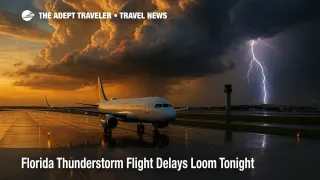
Convective storms are rumbling back across the Sunshine State this evening, and the Federal Aviation Administration's Daily Air Traffic Report warns that every major Florida hub-from Miami to Tampa-could face ground stops or flow-rate reductions. Minneapolis-St. Paul International Airport (MSP) is in the same boat, while low clouds threaten to trim early-morning capacity at Hartsfield-Jackson Atlanta (ATL), Charlotte Douglas (CLT), Los Angeles (LAX), San Diego (SAN), and Seattle-Tacoma (SEA). Travelers with tight connections should brace for rolling delays and monitor airline alerts closely.
Key Points
- Why it matters: Storm-triggered initiatives at a single hub can ripple through dozens of spoke airports nationwide.
- Travel impact: Florida departures after 6 p.m. Eastern could stack up on ramps as towers sequence arrivals.
- What's next: The Air Traffic Control System Command Center will reevaluate at its 9 p.m. planning webinar; additional initiatives are likely.
Snapshot
Thunderstorm cells are expected to flare along the Interstate 4 corridor before drifting south toward Miami International Airport (MIA) and Fort Lauderdale-Hollywood International Airport (FLL). Flow constraints could extend to Orlando International (MCO), Palm Beach International (PBI), and Tampa International (TPA). The same convective line may graze MSP, where controllers already anticipate arrival-rate cuts. On the West Coast, a persistent marine layer threatens to keep ceilings below 2,000 feet at LAX and SAN through the morning push, with similar stratus lingering at SEA.
Background
The FAA's Daily Air Traffic Report, published each morning, distills National Weather Service data, pilot reports, and radar trends into an operations blueprint for the next 24 hours. Airlines use the bulletin-along with real-time ATCSCC advisories-to plan fuel loads, route swaps, and crew contingencies. Weather remains the chief disruptor in U.S. airspace, accounting for more than 74 percent of delays longer than 15 minutes between 2017 and 2023. Earlier today, The Adept Traveler broke down the morning edition of the report; tonight's update refines that outlook as storm cells intensify. (See our full recap here.)
Latest Developments
Convective Line Targets Florida Hubs
An ATCSCC operations plan issued at 2 p.m. Eastern flags "thunderstorms impacting central and south Florida" through at least 11 p.m. Ground-delay programs (GDPs) or ground stops (GSs) remain on the table for MIA, FLL, and MCO. If GDPs are launched, departure holdings at origin cities could exceed 90 minutes; GSs would halt inbound traffic entirely until cells clear approach paths. Lightning proximity rules could further slow ramp operations, forcing aircraft to wait for gate agents to resume loading and fueling.
Low Clouds Threaten Coast-to-Coast Morning Banks
Marine-layer stratus continues to blanket ATL, CLT, LAX, SAN, and SEA overnight, with terminal forecasts calling for ceilings between 400 and 1,200 feet. Low-visibility approaches cut arrival rates by as much as 30 percent, prompting carriers to pad flight times, tank extra fuel, or reroute via secondary hubs. While most operations resume by late morning, early departures-especially red-eyes from Hawaii or Latin America-may absorb holding-pattern delays.
Analysis
Thunderstorms and low ceilings represent a one-two punch that stresses every node of the airline network. Florida's summer storms move quickly but unpredictably; when they park over a runway threshold, the knock-on effect cascades through aircraft rotations, crew duty limits, and maintenance schedules. Tonight's threat is magnified by Florida's heavy leisure traffic-fully booked flights leave dispatchers with few options for re-accommodation. Meanwhile, low clouds at ATL and CLT jeopardize two of the East Coast's critical connecting hubs. If those fields drop below approach minima during the morning push, flights feeding the Midwest and Northeast could mis-connect passengers well into Thursday. West-Coast stratus at LAX and SAN compounds the problem for trans-con travelers, compressing gate availability and delaying turn-times just as East-bound banks depart.
Airlines will lean on strategic route-management and GDP slot-swaps to keep the system moving, but travelers can mitigate personal risk by opting into push alerts, keeping carry-on essentials handy, and accepting same-day changes the moment they appear in the app. Flexibility remains the best defense against the FAA Daily Air Traffic Report's worst-case scenarios.
Final Thoughts
With Florida thunderstorm flight delays poised to snarl evening departures and low clouds set to squeeze morning arrival rates, tonight's FAA Daily Air Traffic Report is a timely reminder to build buffer time into itineraries. Keep tabs on airline notifications, monitor gate screens, and have a backup plan; proactive steps now can spare you stranded-in-the-terminal headaches later, especially when Florida thunderstorm flight delays ripple nationwide.