Priscilla intensifies; watches up for southern Baja as Mexican Riviera impacts build
Priscilla continued strengthening on October 7, prompting a tropical storm watch for southern Baja California Sur and compounding coastal hazards along the Mexican Riviera. The 5:00 a.m. MST National Hurricane Center advisory listed maximum sustained winds of 100 mph and placed the center about 260 miles west-southwest of Cabo Corrientes and 230 miles south of the Baja Sur tip. Authorities have closed schools in Los Cabos and La Paz, restricted small-craft navigation, and begun selective port closures while cruise lines adjust itineraries.
Key points
- Why it matters: Strengthening storm with hazardous surf, rip currents, and squalls across key resort corridors.
- Travel impact: Flight delays possible at Puerto Vallarta, Manzanillo, and Los Cabos; small-craft bans and port limits in effect.
- What's next: NHC expects Priscilla to near major-hurricane strength today before gradual weakening midweek.
- Tropical storm watch spans Cabo San Lucas to Cabo San Lázaro in Baja California Sur.
- Cruise calls to Cabo San Lucas already canceled or swapped on select West Coast sailings.
Snapshot
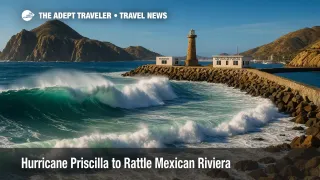
At 5:00 a.m. MST on October 7, Priscilla had 100-mph winds, moving northwest at 10 mph. A tropical storm watch covers Baja California Sur from Cabo San Lucas to Cabo San Lázaro, where 1 to 4 inches of rain and dangerous surf are expected today through Wednesday. Outer bands are producing squalls and high surf along Jalisco and Colima, where small-craft restrictions and selective port closures have begun. Expect beach red flags, intermittent road flooding, and marine suspensions to ripple through tour operations. Air travelers should monitor reflowed departure times and connection risks, especially for late-day banks.
Background
This system has run parallel to the southwest Mexico coast since the weekend, feeding long-period swells into resort zones around Bahía de Banderas and the Costalegre. Local authorities in Baja California Sur preemptively closed schools on October 7 in Los Cabos and La Paz as shelters opened for at-risk residents. Port captains in Jalisco and Colima have restricted or suspended small-vessel navigation, with Manzanillo limiting operations as seas built. For route planning and context, see our earlier coverage of expected conditions on the coast and Baja corridors, including medium-range guidance and port readiness: Mexican Riviera outlook: Priscilla, Oct. 5-7 and Hurricane Priscilla strengthens off Mexico; air and cruise adjustments building.
Latest developments
Tropical storm watch for southern Baja; 100-mph winds on the 5:00 a.m. MST advisory
The National Hurricane Center's 5:00 a.m. MST intermediate advisory (Advisory 11A) places Priscilla's center at 19.6N, 109.6W with 100-mph winds, moving northwest at 10 mph, minimum central pressure 967 mb. The tropical storm watch extends from Cabo San Lucas to Cabo San Lázaro, with tropical-storm-force winds possible later today into Wednesday. NHC projects the center to track parallel to, but offshore of, west-central Mexico and southern Baja in the next couple of days, with a window to reach near-major strength today before weakening on Wednesday.
Coastal and port status tightening from Jalisco to Colima and Baja Sur
Puerto Vallarta authorities have suspended small-vessel navigation in the bay and issued beach hazard warnings as surf and rip currents build. In Colima, officials have limited access to beaches and closed Manzanillo to smaller craft due to deteriorating conditions. In Los Cabos, local reporting indicates marinas have curtailed nautical activities as the watch takes effect and outer bands arrive. Expect rolling port-captain updates, selective closures, and rapid-change windows as squall lines rotate ashore.
Cruise lines begin switching Cabo calls; expect more near-term adjustments
Royal Caribbean's Radiance of the Seas October 4 sailing dropped Cabo San Lucas and Mazatlán, adding sea days. Carnival Panorama altered a Mexican Riviera run, replacing Cabo with alternative ports and sea days in response to swell and tender-safety limits at Cabo San Lucas. Additional near-term calls to Cabo are at risk as tender operations become unsafe in rising seas; guests should check their line's app and email for reflow notices.
Analysis
Aviation: Licenciado Gustavo Díaz Ordaz International Airport (PVR), Playa de Oro International Airport (ZLO), and Los Cabos International Airport (SJD) typically remain open in tropical conditions, but ground stops, runway-crosswind holds, and flow-control delays can stack up during squalls. Expect the highest risk of departure and arrival pushes in late afternoon and evening banks when convective bands rotate through. Reflow-sensitive connections at Mexico City or U.S. gateways may require longer minimum connection times. Build slack into itineraries, monitor airline alerts, and use same-day change tools proactively.
Ports and beaches: Red-flag surf, sneaker sets, and rip currents are the primary threats for travelers today through Wednesday. Even where beaches are "open," lifeguards may restrict swimming; heed posted warnings. Port captains can escalate from small-craft restrictions to broader closures quickly as seas steepen; tours on pangas, dive boats, and sportfishing vessels are most vulnerable to cancellation.
Cruise operations: Cabo San Lucas relies on tendering, which becomes untenable with long-period swell and gusty squalls. Lines are already pivoting, and more substitutions are likely until the swell subsides after Priscilla turns over cooler water midweek. Passengers should watch for automatic excursion refunds, shifted port times, and extended sea days.
Bottom line: If you are flying or sailing into Boston Logan-style hub connections via the West Coast to reach these resorts, pad your timeline, track your EDCTs, and secure refundable transfers. Expect intermittent delays at PVR, ZLO, and SJD, rolling marine suspensions, and additional cruise changes as Priscilla evolves.
Final thoughts
Priscilla's current intensity and track keep the core offshore, but its reach is already reshaping plans along the Mexican Riviera and southern Baja. Travelers should expect shifting flight times, intermittent road flooding, and marine suspensions through Wednesday, with improving conditions late week as the cyclone weakens over cooler water. Keep plans flexible, monitor airline and cruise notifications, and prioritize safety around surf and rip currents. We will continue tracking how ports, airports, and lines adapt to Hurricane Priscilla.
Sources
- Hurricane Priscilla Intermediate Advisory 11A, National Hurricane Center, 5:00 a.m. MST Oct. 7
- Hurricane Priscilla strengthens to a Category 2 storm; schools closed in Los Cabos and La Paz, Associated Press
- Puerto Vallarta small-craft navigation suspended; beach warnings issued, Vallarta Daily
- Manzanillo closes to smaller craft due to Priscilla, El Comentario / UColima
- Radiance of the Seas drops Cabo San Lucas and Mazatlán (voyage Oct. 4), Royal Caribbean Blog
- Carnival Panorama swaps Cabo for alternate ports amid Priscilla, Cruise Radio