Lake Effect Snow May Disrupt Chicago Flights Monday
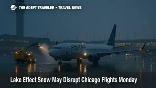
A focused lake effect snow event is set to develop off Lake Michigan from Sunday evening, November 9, into Monday, November 10, bringing narrow but intense snow bands to northeast Illinois and northwest Indiana. The National Weather Service has issued Winter Storm Warnings for Cook County, Illinois, and for Lake and Porter Counties in Indiana, with peak rates that may briefly exceed 2 to 3 inches per hour inside the band. Flyers using Chicago O'Hare International Airport (ORD) and Chicago Midway International Airport (MDW) should build in buffers, avoid tight connections, and expect deicing and periodic ground delays as bands move onshore and shift during the morning push.
National Weather Service outlook
NWS Chicago describes a high-impact, highly localized setup. Very cold air passing over warm lake waters will generate deep convective clouds and a persistent snow band that pivots into the shoreline, then migrates inland and southeast with time. Inside the band, whiteouts and rapid accumulations are likely. Outside of it, impacts will be far lighter. Official warnings for Lake and Porter Counties in Indiana run from Sunday evening through late Monday afternoon. A warning for the Chicago lakefront and adjacent suburbs runs from 9:00 p.m. CT Sunday through midday Monday, with the agency flagging brief, intense snow rates and dangerous travel where the band stalls.
What that means for O'Hare and Midway
Airports behave like small cities, and this kind of banded snow creates uneven effects across runways and ramp areas. Expect multiple rounds of deicing that lengthen taxi-out times. If the band sits over the field during a departure or arrival bank, the FAA can meter arrivals through a Ground Delay Program, or briefly hold departures until rates improve. The national operations plan already lists intermittent delay programs this weekend at large hubs, and Chicago's terminals have seen periodic traffic management initiatives during the broader FAA capacity cuts. Combine those baseline trims with lake effect banding and you get a stop-and-go morning with longer blocks gate to gate.
For connections, aim for 90 minutes minimum at O'Hare in the morning wave, and two hours if you need to change terminals or pass through customs. At Midway, 60 to 90 minutes is reasonable if the band is not sitting over the airfield, but add time for deicing queues during the peak. If your airline offers a no-fee same-day change, moving to an earlier departure can help you beat the most intense band.
Highway and transit pinch points
Lake effect events amplify the gradient between neighborhoods. Expect fast-changing conditions along the Kennedy and Edens (I-90, I-94), the Dan Ryan and Bishop Ford (I-94), the Tri-State and Eisenhower connectors, and especially the Skyway and I-80 corridor into northwest Indiana. Road surfaces can go from wet to snow-covered within a few exits as the band swings. Before leaving for the airport, check Illinois DOT's winter map for live surface conditions and plow progress. If you are within the warned counties, consider CTA rail for Midway and the Blue Line for O'Hare to bypass highway slowdowns.
Why lake effect varies so much
Unlike a broad synoptic storm, lake effect is a lake-driven conveyor. Cold air crossing the warm lake picks up heat and moisture, then organizes into bands that focus lift and snowfall in very narrow corridors. A modest wind shift can displace the band by miles, which is why some neighborhoods see heavy totals while others only get flurries. The current setup features unusually cold air aloft over near-record-warm lake water, increasing instability and boosting snow-growth efficiency inside the band. That is the recipe for bursts that briefly overwhelm plows and airport operations.
Practical steps for travelers
If you fly Sunday night or Monday morning, monitor your airline app for gate and time changes, plus push alerts about deicing delays. When possible, move to flights outside the most likely band timing, which centers on Sunday night through late Monday morning along the immediate lakeshore and into northwest Indiana. Pack medication and essentials in your carry-on in case your checked bag lags behind. If you are driving to the airport from the north or south lakefront, allow extra time where the band crosses Lake Shore Drive, and keep a fallback route to reach the expressway if shoreline conditions deteriorate. Finally, if your plans are flexible, mid-day Monday departures often recover first once the band weakens or shifts inland.
Final thoughts
Lake effect snow is not a regionwide blizzard, but the narrow band can deliver blizzard-like bursts that ripple through airport and highway operations. With Winter Storm Warnings in effect for parts of the Chicago area, the safest plan is to add buffer time, protect connections, and use official FAA and DOT tools before you travel. Lake effect variability is the key phrase, and it will define Monday's airport impacts in Chicago.
Sources
- NWS Forecast Office Chicago, IL
- NWS Chicago, Winter Storm Warning Text, Lake IN and Porter
- NWS Chicago Area Forecast Discussion, Nov 9, 2025
- NWS Chicago Decision Support Briefing PDF, Nov 9, 2025
- FAA Current Operations Plan Advisory
- Illinois DOT, Getting Around Illinois, Winter Conditions Map
- NBC Chicago, Ground Stop Timing and Delays Context