Pacific Northwest Floods Cut BC And US Highways
Pacific Northwest highway closures are now cutting most overland links between Vancouver and interior cities after a powerful atmospheric river brought days of heavy rain starting on December 8, 2025. Record or near record river levels in southern British Columbia and western Washington have triggered states of emergency, evacuation orders, and a rolling sequence of road blocks that leave many winter road trips and tour itineraries temporarily unworkable. Travelers who planned to drive between the coast and interior ski areas, or to pair flights into Vancouver or Seattle with bus or rental car connections, now need to rethink routing, add significant buffer time, or in some cases postpone travel altogether.
What began as a Pacific Northwest storm forecast has evolved into a regional transport crisis where most direct coast interior road links are cut or constrained on both sides of the border, raising knock on risks for flights and ferries as crews, passengers and supplies struggle to move. This article updates Adept Traveler coverage in US Atmospheric River, Midwest Blizzard Hit Holiday Travel and BC Highway 4 Closure And Ferries Hit By Atmospheric River, focusing on the specific corridors now closed, the emerging reopening pattern, and when travelers should reroute versus simply stay put.
Coast To Interior Highways Cut In British Columbia
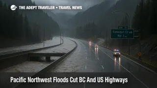
British Columbia officials now confirm that all four primary highway links between the Lower Mainland and the Interior have been closed at various points, including Highway 1 through the Fraser Canyon, Highway 3 over Hope Princeton, Highway 5 on the Coquihalla, and Highway 99 between Mount Currie and Lillooet. Additional closures or restrictions have hit Highway 7 east of Mission and Highway 11 at the Sumas border crossing, while local levee concerns and saturated slopes keep timelines for full reopening uncertain.
Provincial advisories describe washouts, flooding at key creek crossings such as Sowaqua on the Coquihalla, debris flows on Hope Princeton, and landslides or high water on Highway 1 and 99. Some stretches, including portions of Highway 1 between Hope and Lytton, have seen brief overnight or single lane reopenings before new rainfall or stability checks forced renewed closures, underscoring how fragile the network remains.
At the same time, the Lower Mainland itself is managing active evacuation orders and alerts, particularly around Sumas Prairie and the Fraser Valley, where Abbotsford has declared a local state of emergency and expanded orders as flood waters rise. Communities along the Nooksack and Sumas system are again watching cross border flows that are being compared with the destructive 2021 floods.
For travelers, the bottom line is that there is currently no reliable direct highway route between Vancouver and interior hubs such as Kamloops, Kelowna, or the Cariboo. Even if a single corridor briefly reopens, it may be restricted to essential or local traffic, might close again without much notice, and will almost certainly be slow, convoy controlled, or heavily patrolled.
Washington Flooding Closes Key Passes And River Corridors
South of the border, Washington Governor Bob Ferguson has issued a statewide emergency as the same atmospheric river drives major flooding from the coast through the Cascade foothills. Forecasters describe this as one of the strongest atmospheric river events to hit the region in decades, with multiple river basins, including the Skagit, Snohomish, Snoqualmie, and Puyallup, either at or approaching major flood stage, and hundreds of National Guard personnel activated to support evacuations and rescues.
Flooding and landslides have already closed a portion of eastbound Interstate 90 near North Bend, a critical link across Snoqualmie Pass between Seattle and central or eastern Washington. Additional closures and restrictions have affected segments of Interstate 5 near Napavine, local highways along the Skagit and Chehalis rivers, and multiple smaller county roads where water has overtopped pavement or undercut shoulders.
While Washington mountain passes are not completely cut off in the same way as the BC Interior, conditions over Snoqualmie and Stevens Pass are volatile, with a mix of heavy rain, snow at higher elevations, and high winds that can shut down traffic with little warning. Drivers trying to reach Spokane, the Tri Cities, or interior ski areas like Mission Ridge or Schweitzer from the coast should treat all pass crossings as high risk, with a real possibility of long delays, rolling closures, and detours along congested secondary routes.
Border Crossings, Rail Links, And Bus Routes
On the Canadian side, Highway 11 at the Sumas border crossing has been closed to commercial traffic and restricted to local use, reflecting both flooding concerns and limited capacity on alternative routes. Even where other land crossings remain open, flooded local roads can make reaching them difficult.
Rail is not a straightforward fallback. Amtrak Cascades has suspended all service between Seattle and Vancouver on December 11 and 12 because trackside flooding and high river levels near the Skagit River make the line unsafe, while trains south of Seattle continue to run. Replacement buses are limited, and in some cases operators are cancelling or truncating runs rather than sending coaches through flooded detours.
Regional intercity bus services that normally use Coquihalla or Hope Princeton routes are in a similar position. Operators are already warning of cancellations, revised timetables, or multihour detours, especially on Vancouver Kelowna, Vancouver Kamloops, and Seattle Vancouver corridors. Travelers should not assume that a booked bus will operate until the operator confirms the run, ideally on the same day.
Knock On Effects For Flights And Ferries
Airports in the region remain open, but ground access is strained. Vancouver International Airport (YVR) and Seattle Tacoma International Airport (SEA) are seeing passengers and crew members arriving late as flooded roads and rerouted buses slow surface transport, which in turn increases the risk of crew timing issues, missed departures, and last minute rebookings, even when the runways themselves are dry.
BC Ferries and Washington State Ferries, already dealing with strong winds and residual swell from earlier phases of the storm, face additional pressure as more travelers try to use coastal routes instead of inland highways. Earlier in the week, Highway 4 closures and high winds forced cancellations on key Vancouver Island sailings, cutting off communities such as Tofino and Ucluelet from easy access. That pattern could repeat on other routes if the storm regenerates or if new systems follow behind.
For anyone pairing flights into Vancouver or Seattle with drives to Whistler, interior BC ski resorts, or Washington mountain towns, the message is simple: same day connections that rely on a long road leg now carry far more risk than usual. Arriving a day early, shifting to interior flights, or postponing the ground segment will be safer than gambling on a narrow transfer window.
When To Reroute Versus Postpone
In the next 24 to 72 hours, most leisure travelers should treat coast interior road trips via BC or Washington as optional only if they have strong local knowledge, flexible timing, and backup accommodation. For everyone else, postponing the drive, switching to an interior flight, or rebooking the entire trip will usually be wiser than trying to thread a gap in the closures.
Travelers who must move, for example to reach essential work postings or return home, should first check DriveBC and Emergency Info BC for real time closure and evacuation maps, then cross reference WSDOT advisories and county emergency feeds on the US side. Any route that passes through an active evacuation zone, or that relies on a single bridge over a major river now near flood crest, should be considered off limits until authorities clearly say otherwise.
If flights are already booked, the more resilient strategy is to shift routings so that long distance flying ends as close as possible to the final destination, and to avoid assuming that a rental car will bridge a long gap. For example, instead of flying to Vancouver then driving to Kelowna, it may be more reliable to fly directly into Kelowna International Airport (YLW) or Kamloops Airport (YKA), even with a connection, and then use local shuttles. US based travelers headed to BC ski resorts might find it easier to route via Calgary or Edmonton for the next few days instead of through Seattle and a highway crossing.
For tours, cruises, and ski packages, travelers should read contracts carefully but also recognize that many operators will offer waivers or credits when states of emergency are in place on both sides of the border. Being proactive, asking about options before no show penalties apply, and documenting closures with official advisories will all help when seeking refunds or rebookings.
Background, How This Atmospheric River Turned Into A Transport Crisis
The December 2025 Pacific Northwest floods are part of a broader pattern of repeated atmospheric rivers that has delivered several days of intense rainfall, with some mountain areas seeing totals measured in hundreds of millimetres and multiple rivers reaching or surpassing historic records. Unlike shorter, localized storms, atmospheric rivers can keep firehose like moisture aimed at the same region for days, overwhelming both natural drainage systems and engineered defenses such as dikes, culverts, and bridge approaches.
In British Columbia, the geography compounds the risk, because a handful of long, winding corridors carry almost all road traffic between the Lower Mainland and the Interior. Once a slide, washout, or levee breach knocks out one or two of those corridors, the remaining routes quickly become saturated, and when all four are compromised the region effectively experiences an overland land lock, even though ports and airports continue to operate.
On the Washington side, the combination of steep mountain slopes, deeply incised river valleys, and extensive development along low lying floodplains means that the same event can simultaneously threaten mountain passes, rural communities, and urban freeway interchanges. The Skagit and Snohomish systems in particular have a long history of damaging floods, and the current event is testing levees and emergency playbooks that were already under review after previous atmospheric river episodes earlier in the decade.
For travelers, this storm is another reminder that climate driven extremes are increasingly turning what used to be routine winter road trips into complex, multi day logistics problems, especially in regions where there are few true alternatives once a main corridor goes down.
Sources
- Major highways between Lower Mainland and BC Interior closed by atmospheric river, BC Government advisory
- Most highways linking BC Interior to Lower Mainland remain closed, Castanet
- Atmospheric river pushes up water levels in southern BC, flood warnings issued, Castanet
- BC evacuation orders expand as floods cut off Lower Mainland, Lethbridge News Now
- Gov Ferguson issues emergency declaration due to heavy flooding, KNKX
- Washington airports brace for flooding as atmospheric river delivers heavy rain, Flying Magazine
- Residents ordered to evacuate as Skagit River approaches record flood levels, The Watchers
- Washington declares state of emergency as atmospheric river slams Northwest, Fox Weather
- Eastbound I 90 closed due to mudslide, Fox 13 Seattle
- Major highways between Lower Mainland and Interior remain closed, DriveBC advisory
- 2025 Pacific Northwest floods overview