Orange Storm Warnings In South Africa December 12 Travel
South Africa orange storm warnings for Friday, December 12, 2025 now sharpen the weather risk for both inland and coastal trips, with an Orange Level 5 severe thunderstorm alert over parts of the Northern Cape, Free State and North West, and damaging waves expected along the Western Cape coast. The South African Weather Service, SAWS, warns that storms could flood roads, low lying bridges and some settlements, while strong swell and rough seas between Saldanha Bay and Plettenberg Bay may disrupt beach and marine activities. Travellers using rental cars, intercity buses and short haul flights should treat December 12 as a high risk day, building in extra time and being willing to delay or reroute key legs.
The new South Africa orange storm warnings for December 12 mean that severe inland thunderstorms and Western Cape coastal waves will complicate road trips, bus routes and some domestic flights, especially for travellers crossing the Northern Cape interior, western Free State, North West and the Cape coast.
Where Orange Level 5 Storm Risk Is Highest
SAWS impact based guidance now pins an Orange Level 5 warning for severe thunderstorms over the interior of the Northern Cape, the western parts of the Free State and much of the North West province. The warning text highlights the risk of flooding of roads and low lying areas, damage to low bridges and to settlements or structures in both urban and rural villages.
For travellers, that translates directly into higher misconnect and safety risk on trunk routes such as the N12 between Kimberley and Klerksdorp, stretches of the N1 and N8 across the Free State plateau, and the N14 and connecting regional roads through North West mining and farming towns. Many of these corridors rely on single carriageway sections, aging drainage and low water crossings that can become unsafe in minutes once intense downpours start. Gravel shortcuts that look tempting on mapping apps are even more vulnerable, with washouts, hidden potholes and soft shoulders that can trap lightly loaded rental cars and minibuses.
Key inland gateways such as Kimberley Airport (KIM), Bram Fischer International Airport (BFN) in Bloemfontein and Upington Airport (UTN) sit close to the Orange Level 5 area. While SAWS does not expect all flights to stop, severe thunderstorms on approach or departure paths can trigger holding patterns, diversions or ground stops that ripple into later legs, especially for aircraft cycling between Johannesburg, Cape Town and these inland fields.
Yellow Level 2 Thunderstorms Around The Edges
Around the core Orange Level 5 zone, SAWS has also issued Yellow Level 2 warnings for severe thunderstorms over the eastern and northern parts of the Northern Cape, central and western parts of the Free State, the western parts of the North West and the central and eastern parts of the Eastern Cape. These alerts emphasise localised flooding of susceptible roads, settlements and low lying bridges, together with periods of heavy rain, strong winds, lightning and possible hail.
Although Yellow Level 2 sits below Orange Level 5 in the hierarchy, the risk is still meaningful on busy holiday corridors. Routes linking Bloemfontein to the Eastern Cape interior, cross country drives from Kimberley toward the Karoo and Garden Route, and regional bus and shuttle services that cut across these provinces can all slow sharply when even a few crossings or town approaches flood. SAWS has also signalled Yellow Level 1 thunderstorm risk in parts of KwaZulu Natal, where earlier storms this season have already produced damaging hail and flash floods, reinforcing the pattern of broad convective instability across central and eastern South Africa.
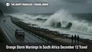
Damaging Waves Along The Western Cape Coast
Along the coast, the December 12 risk profile looks different but just as relevant for holidaymakers. SAWS has issued a Yellow Level 2 warning for damaging waves between Saldanha Bay and Cape Agulhas from Friday evening, with the zone spreading east to reach Plettenberg Bay on Saturday. The warning notes that large, steep waves will make navigation at sea more difficult and can cause localised disruption to beachfront activities, including informal launch sites, small harbours and exposed swimming beaches.
Travellers heading for West Coast villages, Cape Town area beaches, Hermanus and the Overberg, or Garden Route towns such as Mossel Bay, Knysna and Plettenberg Bay should not assume that clear skies equal safe surf. Strong swell and rough seas can create powerful shore break, strong rip currents and occasional overwash of low coastal roads and parking areas, even when the weather overhead looks fairly benign. Small boat trips, including fishing charters, whale watching style excursions and some inter resort transfers, are particularly exposed to short notice cancellation or schedule changes when wave and wind warnings like this are active.
What Orange Level 5 Means In Practice
South Africa's impact based warning system is designed to communicate expected consequences, not just raw weather forecasts. In that system, yellow warnings indicate moderate risk that needs caution and awareness, while orange denotes a higher risk of significant impacts on people, infrastructure and services that requires increased attention and preparation.
Numbered levels overlay the colour to describe the likelihood of impact. Level 5 sits toward the high likelihood end of the scale, signalling that severe thunderstorms are not only possible, but likely to cause real world problems such as flooded roads and low lying areas, damage to vulnerable settlements and interruptions to essential services.
For travellers, that means an Orange Level 5 day is not business as usual with an umbrella. It is a day to move nonessential driving off the table where possible, to treat any flooded crossing as a hard no instead of a challenge and to build enough slack into essential trips that waiting out a storm at a safe stop remains a viable choice.
How To Adjust December 12 Itineraries
On December 12, anyone planning a long drive through the Orange Level 5 region should try to keep that leg in broad daylight, start earlier than usual and aim to reach their overnight stop or major interchange before the late afternoon and evening thunderstorm window. If SAWS, local media or route operators report active flooding, hail or strong storms along a planned corridor, the safer move is often to delay departure, reroute via higher ground, or even shift the leg to December 13 or 14 if the forecast trend allows.
Intercity bus passengers and those using scheduled shuttles should assume slower running times and have backup accommodation options in case a leg has to be split or an arrival falls too late for an onward connection. Where possible, pick departures that avoid the peak storm period and avoid tight onward plans on separate tickets, particularly for early evening domestic flights out of Johannesburg or Cape Town that depend on arriving by road from the Orange Level 5 region.
For domestic flights, the main inland hubs will remain Johannesburg and Cape Town, but aircraft cycling through Kimberley, Bloemfontein, Upington and smaller fields may still face storm related delays. Travellers driving into those airports should allow additional driving time for water on the roads and temporary closures, and then leave more buffer than usual between arrival and scheduled departure to absorb any queueing at security or check in caused by earlier disruptions.
On the coast, Friday evening and Saturday beach days along the Western Cape should now be treated as weather conditional. If local authorities or lifeguards close certain accesses or warn of dangerous surf, the right answer is to comply and switch to inland activities instead of pushing into closed zones for a quick swim or photo. Small boat excursions are best treated as tentative until the operator confirms on the day, with flexible back up plans and no essential same day connections tied directly to a risky launch window.
How This Update Fits Earlier Storm Coverage
Adept Traveler has tracked South Africa's early summer storm pattern in pieces such as South Africa Storm Warnings Hit Travel December 1 and South Africa Storm Warnings Hit Holiday Road Trips, which focused on Yellow Level 2 and Level 4 thunderstorm belts affecting Gauteng, KwaZulu Natal, Limpopo, Mpumalanga and adjacent provinces. The December 12 update shifts the centre of gravity west and south, with an explicit Orange Level 5 inland focus and a parallel marine risk for the Western Cape coast, underlining that the broader storm phase is now a national planning constraint rather than a single corridor problem.
Travellers using South Africa as a hub or destination over the next few days should treat the current warnings as a strong signal to respect local advice, to keep itineraries flexible and to build in more weather buffer than they might normally consider. Used alongside the South Africa destination guide, this South Africa orange storm warnings update helps set realistic expectations for December 12 travel and for the storm susceptible days that follow.
Background: SAWS Impact Based Warnings
SAWS describes its impact based severe weather warning system as a way to warn the public about possible impacts that could occur as a result of hazardous weather, not just about wind speeds or rainfall totals. That is why warning text for December 12 talks explicitly about flooded roads, low lying bridges, settlements and coastal activities, giving travellers concrete cues on how to adjust plans rather than just signalling that it will be stormy.
For travellers, the working rule is straightforward. Yellow Level 2 days demand caution and flexibility, Orange Level 5 days demand active risk management and a willingness to delay or reroute. On December 12, 2025, South Africa sits firmly in that second category across parts of the interior and Western Cape coast, so planning around the South Africa orange storm warnings is now part of travelling safely.
Sources
- South African Weather Service, warnings and travellers forecast
- News24, Friday's weather: Severe thunderstorms, warnings of damaging waves, winds in parts of SA
- The Citizen, Thunderstorms and rough seas: Here's what weather to expect on Friday
- Vox Weather, 12 December daily forecast summary
- SnowReport SA, South Africa weather forecast and warnings context
- Adept Traveler, South Africa Storm Warnings Hit Holiday Road Trips