Storm Bram Cleanup Disrupts UK And Ireland Travel
Travelers with December itineraries that touch Ireland and the United Kingdom now need to treat Storm Bram UK Ireland travel disruption as a multi stage problem, not a one day storm that has already passed. The first wave of impacts, including cancelled flights, flooded roads, and rail slowdowns, is giving way to cleanup that still leaves pockets of damage and power cuts, while forecasters track more Atlantic systems that could bring fresh bursts of strong wind, heavy rain, and localised flooding through mid December. In practical terms, that means schedules may look normal again on paper, but tight airport transfers, rural self drive plans, and small ferry hops remain fragile for at least several more days.
The core shift for travelers compared with earlier Storm Bram alerts is that the storm has moved from a live wall of wind and rain into a messy recovery period, just as the broader North Atlantic pattern stays unsettled. That combination of lingering damage and new fronts means travelers need to zoom in on the counties and corridors that were hit hardest, build more conservative buffers around Dublin, Shannon, and Belfast connections, and be ready to move trips later in December if the next low pressure pulse lands on an already stretched itinerary.
Ireland cleanup, from peak outages to local repairs
At the height of the storm, Irish outlets report that more than 54,000 homes, farms, and businesses lost electricity as Bram brought severe winds, downed trees, and localised flooding, particularly across southern and western counties such as Cork and Kerry. By December 10, that number had reportedly fallen to roughly 2,500 customers still without power, but utilities were still working through scattered faults on rural lines, and some roads remained blocked or narrowed by debris and standing water. For visitors, that translates into occasional dark pockets in the countryside, temporary traffic control on narrow roads, and potential last minute changes for guesthouses that rely on electrically powered heating and hot water.
Irish transport and government briefings underline that the damage has not been uniform. Coastal stretches and river lowlands took the sharpest hit, with Christmas markets, local festivals, and some attractions closing during the worst of the winds and now reopening on a case by case basis. Inland towns that saw mainly high wind and surface water may look normal by the time travelers arrive, while pockets along rivers and in exposed rural locations are still pumping out basements, checking bridges, and cleaning up landslides or verge collapses. If an itinerary leans heavily on country lanes, coastal viewpoints, and small villages, it is worth checking local council and tourism pages for closure notices before committing to long day drives.
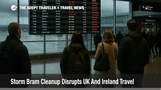
Airports, airlines, and knock on delays
For air travel, the sharpest disruption is in the rear view mirror but some ripple effects remain. Dublin Airport (DUB) confirmed that 73 flights, split between arrivals and departures, were cancelled during the peak Bram window as strong crosswinds exceeded safe limits, with further delays as wind speeds built and aircraft and crews fell out of position. Media reports place the total number of affected flights across the day at close to 100, including a much discussed Ryanair Manchester to Dublin service that twice abandoned landing attempts in the crosswinds and had to return to Manchester before finally completing the hop later that evening.
Operations at Dublin, Shannon Airport (SNN), Cork Airport (ORK), and Ireland West Airport (NOC) have largely normalised, but the practical risk for travelers over the coming days is less about fresh mass cancellations and more about occasional rolling delays and aircraft swaps as airlines work through crew hours and maintenance windows. If you are connecting through Dublin on separate tickets, or relying on a last evening departure to make a morning meeting in London or Amsterdam, the safer move is to shift onto a slightly earlier rotation and to treat three hours as a baseline buffer for international connections.
Belfast International Airport (BFS) and George Best Belfast City Airport (BHD) saw fewer cancellations than Dublin during Bram, but they sit in the same broader Atlantic storm track. As new systems spin in, brief windows of high wind or low cloud could still force holding patterns or diversions, particularly for larger aircraft on crosswind sensitive runways. Aligning travel days with more settled forecast windows, rather than simply picking the cheapest fare, remains a sensible tactic through at least the middle of December.
UK impacts and the next Atlantic pulses
Across the Irish Sea, the UK Met Office notes that Bram has now moved away to the north of the country, leaving behind a patchwork of flooded river valleys, saturated ground, and transport disruption in parts of England, Wales, and Scotland. In some places, such as low lying sports grounds in Worcestershire, floodwater has again turned fields into temporary lakes, underlining how quickly rivers have been overtopping their banks in this sequence of storms.
The more important signal for trip planning is that the same forecast discussions talk about further frontal systems rolling in off the Atlantic in the days after Bram. These systems may not earn formal storm names, but they can still bring periods of heavy rain, strong winds, and poor visibility that trigger local flood alerts and short notice rail, road, and ferry disruption, especially where catchments are already saturated. In plain language, travelers should expect a stop start pattern, with short windows of calm weather followed by renewed bursts of high impact rain and wind, rather than a clean break back to quiet winter conditions.
New Irish warnings and marine risks
Met Éireann has wound down its earlier Status Orange land alerts, but a fresh Status Yellow wind warning has been issued for counties Galway, Kerry, and Mayo, flagging difficult travel conditions, the risk of fallen trees, and scattered debris in some of the same areas that were hardest hit by Bram. For the sea, a Small Craft warning remains in force for stretches of the Irish coast, with south to southwesterly winds of force 6 or 7 expected through at least December 12, a setup that can easily push smaller ferries and open boat transfers off schedule.
For visitors, that means overland routes between hubs such as Dublin and Galway, or between Shannon and the Dingle Peninsula, may still encounter short notice lane closures or local diversions, and that inter island and peninsula ferry services will be especially vulnerable to last minute changes. Booking flexible tickets where possible, and keeping at least one land based alternative for any ferry dependent excursion, will reduce the odds of a trip being derailed by a late warning extension.
How much buffer to allow for December trips
Given the mix of cleanup and further Atlantic systems, buffers for December 2025 trips through Ireland and the UK should now look more like deep winter planning than early shoulder season optimism. For flights that connect through Dublin or London on a single ticket, aim for at least a two and a half to three hour connection window, and accept overnighting at the hub if missing the onward leg would have high stakes. For separate tickets, tack on an extra hour on top of that, or avoid separate tickets altogether on days when forecasts flag stronger systems moving through.
On the ground, rental car itineraries in Ireland that rely heavily on rural B roads and mountain passes should build in extra daylight buffer rather than pushing long drives into the dark. Standing water and debris that are merely inconvenient during the day become much harder to read at night, especially for visitors who are adjusting to driving on the left. Where possible, keep key transfers between Dublin, Shannon, or Belfast and countryside bases in mid morning or early afternoon slots, and treat the last bus or last train of the day as a backup rather than the main plan.
For rail and coach travel, previous Adept coverage of Storm Bram Disrupts UK And Ireland Travel Networks and Storm Claudia To Disrupt UK And Ireland Travel gives a useful template, namely that mainline rail tends to recover quickly once winds ease, but secondary routes and branch lines can see longer suspensions after trees fall or embankments fail. Booking earlier departures on busy weekends, or holding seats one band earlier than the absolute latest train you could take, will increase the odds of making onward flights or ferries on time.
Background, how the warnings and patterns work
As explained in our earlier Ireland focused Bram coverage, Met Éireann uses a three tier colour code, Status Yellow, Status Orange, and Status Red, to signal expected storm impacts, while the UK Met Office uses yellow, amber, and red weather warnings for rain, wind, ice, and other hazards. Yellow warnings point to conditions that can still be disruptive for travel, especially when ground is already saturated, while orange or amber alerts flag a much higher risk of transport and power disruption, and red warnings are reserved for rare, dangerous conditions with a clear threat to life.
The current pattern, with earlier orange and amber warnings and now renewed yellow alerts plus marine advisories, fits a classic winter Atlantic sequence where one named storm is followed by a parade of lesser but still impactful systems. Travelers who have already bookmarked the Met Éireann and Met Office warning pages, and who treat those colour codes as operational cues rather than background information, will be better placed to adjust plans before queues build at airports, rail stations, and ferry terminals. For broader structural context on how weather trends are reshaping European trip planning, Adept Traveler's analysis of Europe's 2025 heatwave and extreme conditions offers an additional framework for thinking about buffers, insurance, and backup routes.
Sources
- Met Éireann, Storm Bram meteorologists commentary and warnings
- Met Éireann, weather warnings and marine advisories
- Met Office, Storm Bram has been named
- Met Office, UK weather forecast for the next 10 days
- Irish Examiner, Storm Bram leaves 25,000 without power
- RTÉ News, Storm Bram repair work under way
- BreakingNews.ie, Storm Bram, 25,000 without power, most warnings lifted
- The Sun Ireland, Full Storm Bram closures list
- Business Insider, Ryanair flight to nowhere in Storm Bram
- Adept Traveler, Storm Bram Hits Ireland Flights, Ferries, Coastal Roads
- Adept Traveler, Storm Bram Disrupts UK And Ireland Travel Networks
- Adept Traveler, Storm Claudia To Disrupt UK And Ireland Travel
- Adept Traveler, Europe's 2025 Heatwave Is Shifting Summer Travel Plans