Northeast Winter Storm Hits Flights December 14, 2025
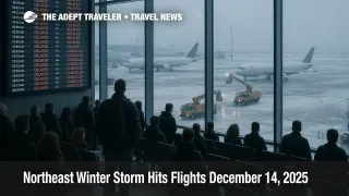
Northeast winter storm flight delays are building across the Washington to Boston corridor on December 14, 2025, as snow, runway treatments, and deicing slow arrival rates at major hubs. Travelers connecting through New York, New Jersey, Philadelphia, and the broader Northeast are most exposed, especially on itineraries with short layovers or late day departures. If you can move your trip, look for same day changes or weather waivers, add connection buffer time, and be ready to reroute around the New York airspace complex.
The practical change behind today's Northeast winter storm flight delays is that the FAA is actively managing demand into constrained airports, while winter operations and worsening cold can keep aircraft turnaround times slow well after the last snow band.
What The FAA Is Doing, And Why It Matters
When winter weather reduces how many arrivals an airport can safely accept, the FAA's Air Traffic Control System Command Center shifts traffic management from ad hoc airborne holding to structured programs that meter departures headed to the constrained airport. In plain terms, you might wait longer at your origin gate so fewer aircraft stack up in the air over the destination. That protects safety and reduces airborne holding, but it can create missed connections, late crews, and gate gridlock as aircraft arrive behind schedule.
In the FAA Command Center's current operations planning view for December 14, snow is impacting the East Coast from Washington to Boston, and programs are in effect at New York area airports due to snow, ice, runway treatments, and throughput limits. The same FAA planning text also flags knock on constraints like runway closures that can further compress capacity during recovery windows.
Most Affected Airports Right Now
The highest risk airports are the New York area gateways, plus the busy corridor airports that feed them.
La Guardia Airport (LGA) is under an FAA traffic management program for snow and ice, with the FAA showing some arriving flights delayed an average of 2 hours and 38 minutes as of the morning status update. Newark International Airport (EWR) is also under an FAA traffic management program for snow and ice, with average arrival delays shown around 2 hours and 50 minutes. Even if your specific flight still shows "on time," these average arrival delays are the kind of system wide cap that quickly turns into gate holds, missed connections, and late inbound aircraft.
Other core corridor airports can shift quickly between "minor delay" and "major disruption" as snow intensity changes and deicing queues build. General Edward Lawrence Logan International Airport (BOS) is reporting short general delays in its FAA status feed, but it remains in the corridor where arrival rates can be reduced quickly if snow bands intensify. Philadelphia International Airport (PHL) is reporting "on time" on the FAA's airport status page, but it is also showing winter conditions in the weather readout, which is consistent with the corridor snow story and the risk of rapid operational changes. John F Kennedy Intl (JFK) shows "on time" on the FAA status page, yet the same page lists light snow and mist, which is exactly the kind of surface condition that can trigger deicing slowdowns and gate churn.
In the Washington area, conditions can look better on the surface while still absorbing downstream disruption. Ronald Reagan Washington Ntl (DCA) is shown as on time on the FAA airport status page. Washington Dulles Intl (IAD) is also shown as on time in the same FAA airport status format, but with strong winds noted, which can complicate winter operations and ramp work. Baltimore washington Intl Thurgood Marshall (BWI) is shown as on time in the FAA airport status page view, though travelers should still expect irregular operations if aircraft rotations arrive late from New York area airports.
What Live Trackers Show, Cancellations Are Already High
For travelers, the most useful reality check is whether cancellations are already stacking up at your departure, destination, or connection airport. FlightAware's national snapshot shows widespread disruption today, with more than 12,000 delays and more than 600 cancellations across the United States at the time of its update.
At the airport level, the New York area is carrying the heaviest visible hit. Newark is showing more than 60 cancellations and more than 150 delays in FlightAware's airport cancellation view. LaGuardia is showing more than 50 cancellations and more than 130 delays. JFK is showing more than 20 cancellations and more than 140 delays. Boston and Philadelphia are showing smaller cancellation totals by comparison in the same FlightAware views, but both still show dozens of delays, which is often how a corridor day starts before the bigger late day cascade.
Why Cold Can Extend Disruption Into Monday
Snow is only half the operational story. In parts of the Mid Atlantic and southern New Jersey region, the National Weather Service briefing from the Mount Holly office describes widespread snowfall totals of 1 to 5 inches, with locally higher amounts possible, and it explicitly warns that bitter cold follows the snow. The same briefing notes the coldest wind chills are expected Sunday night into Monday morning, a window that can keep deicing demand high and reduce how fast airports can dig out of gate and taxiway congestion.
For travelers, that means a Sunday cancellation can easily turn into a Monday morning misconnect problem if aircraft and crews do not reposition overnight, or if deicing lines restart before the system has absorbed the backlog.
Airline Waivers To Check Before You Change Anything
Do not guess at rebooking rules, check whether your ticket is covered by a published winter weather waiver, because that is what typically unlocks one time free changes, date flexibility, or a fare difference waiver.
United has published a winter weather travel waiver covering a long list of Northeast airports and multiple travel dates, with specific rebooking conditions spelled out in the waiver text. Delta's SkyWatch advisories page is also posting a winter weather advisory with covered cities, dates, and change guidance for affected travelers. If your carrier is not listed here, check its "travel alerts" page and your booking in the airline app, because some waivers are targeted by airport and date, and others are attached directly to reservations.
Practical Rebooking And Connection Buffer Guidance
If you have not left for the airport, the best move is often to shift earlier or later, not to "wait it out" at the gate. Early departures sometimes operate before cancellation decisions snowball, but once average arrival delays at your destination are running multiple hours, late day flights are vulnerable to missing crews, timing out, or losing gate space.
If you must travel today, treat any connection through the New York area as fragile. Build at least 90 to 120 minutes for domestic connections, and more if you have to change terminals, reclaim bags, or clear security again. If your itinerary includes the last flight of the day to a smaller city, consider rerouting to arrive earlier, or position to a nearby alternate airport where you have more flight options if the final leg cancels.
If you are traveling for something that cannot slip, like a cruise embarkation, a paid tour, or a medical appointment, the risk calculus changes. In that case, rebook to arrive earlier than planned, or move the trip to Monday afternoon or Tuesday, because the cold air behind the snow can keep recovery slower than travelers expect.
For related coverage and context, see our daily delay tracker from Saturday, which explains how FAA programs can shift waiting time to your origin airport, plus a prior Newark ground stop case study that shows how quickly a hub disruption ripples nationwide, and our holiday travel planning guide for buffer strategies that still work in winter storm weeks.
Sources
- Current Operations Plan Advisory, FAA ATCSCC
- La Guardia Airport (LGA) Real time Status, FAA
- Newark International Airport (EWR) Real time Status, FAA
- FlightAware Airport Delays and Cancellations
- FlightAware Cancellations, Newark (EWR)
- FlightAware Cancellations, LaGuardia (LGA)
- NWS Mount Holly Briefing, December 14 to 16, 2025
- United Travel Waiver, Winter Weather
- Delta SkyWatch Travel Advisories