Flight Delays And Airport Impacts: December 14, 2025
US flight delays December 14, 2025 are building across the Northeast corridor as snow and runway treatments reduce airport arrival and departure capacity from the New York City area through Washington, D.C., and toward Boston. Travelers connecting through the region, or trying to reposition into New York for international departures, are the most likely to feel the ripple effects. The practical move is to avoid tight same day connections, favor earlier departures where you still can, and check for waiver based changes before you commit to a long airport wait.
The FAA's current operations plan flagged programs in effect at LaGuardia and Newark for snow, ice, runway treatments, and throughput, and it also pointed to possible programs at Philadelphia, Reagan National, JFK, and Boston as the day develops.
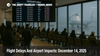
By early morning, the delay picture was already visible in public tracking data. FlightAware's live statistics showed 12,198 total delays and 619 total cancellations worldwide, with 1,661 delays and 259 cancellations tied to flights within, into, or out of the United States. In its airport delay list around the same window, FlightAware showed average departure delays approaching about an hour at Newark and JFK, with elevated delay averages also posted for LaGuardia, Reagan National, and Dulles.
What Is Driving Today's Delays
The core constraint is winter weather timing plus winter operations. New York City Emergency Management warned of a fast moving coastal storm and noted a Winter Weather Advisory window that concentrated the steadiest snow Sunday morning, with forecast totals around a couple inches citywide and locally higher amounts. National Weather Service advisory text for parts of the broader region also highlighted snow accumulations in the 2 to 4 inch range with localized higher totals, a combination that is usually enough to trigger repeated runway treatment cycles and slower taxi operations at big, tightly scheduled hubs.
For air travelers, the difference between a messy drive and a messy flight day is runway throughput. When snow is falling or surfaces are being treated, airports often switch to more conservative spacing on final approach, reduce departure rates, and build in extra time for deicing. That creates gate holds, missed departure slots, and late inbound aircraft, which then cascade into crews timing out and aircraft being out of position for later flights. Even if your origin airport is clear, a delay at your destination or along your aircraft's earlier route can still hit you.
The FAA's planning note also showed several operational details that matter for travelers even when they sound technical. For example, it listed a runway closure at Newark (Runway 4L and 22R) into the morning hours, a factor that can further reduce arrival flexibility during a snow constrained period. It also flagged staffing triggers in the Philadelphia area, and referenced "diversion recovery" across Boston, New York, and Philadelphia, which is the kind of back end cleanup that can keep schedules unstable into the afternoon.
How To Read FAA Timing In Plain English
FAA advisories often use Zulu time (UTC). On December 14, Eastern Standard Time is UTC minus five hours. So, a time like 1700Z corresponds to 12:00 p.m. EST. When you see "possible" ground stops or delay programs listed later in Z time, treat that as a heads up that late morning through afternoon flights may face additional flow restrictions even if your morning departure looks fine right now.
Where The Risk Spreads Beyond The Northeast
Today is not only a Northeast story. The FAA's operations plan also flagged wind at Atlanta, thunderstorms affecting South Florida and multiple en route sectors, and low ceilings that can pressure Seattle and San Francisco. For travelers, this matters because when a large network carrier starts reflowing aircraft around one constrained region, it often pulls spare aircraft and crews from elsewhere, leaving fewer options if something goes wrong on a separate weather front.
The FAA also referenced an equipment outage affecting routes tied to Havana, plus constraint messaging around Cancun arrival routes. Most travelers will not need to do anything special with that information, but if you are flying to Florida, the Caribbean, Mexico, or connecting over South Florida hubs, it is another reason to watch your inbound aircraft and not assume a short published delay will stay short.
What Travelers Should Do Now
If you have not left home, check your airline app, the airport's departure page, and your aircraft's inbound flight. In a snow constrained day, the inbound aircraft status is often the best early warning. If you see your aircraft arriving late, assume your departure will also slide.
If you have a connection through the New York area or Washington, build more buffer than you think you need. For any itinerary with a must make event, treat a 90 minute connection as risky and a sub 60 minute connection as a likely misconnect if weather programs expand. If your airline offers a same day change option, or issues a weather waiver, using it early can be the difference between a smooth reroute and being stuck with whatever seats remain after the first wave of cancellations.
Finally, pack for the airport you may be stuck in, not the destination you hope to reach. Snow days create long gate holds and slow rebooking lines. Water, snacks, charging cables, and cold weather layers for curbside waits can turn a bad day into an annoying one instead of a miserable one.
For additional context on how these winter disruption patterns have been stacking up this month, see our coverage of Flight Delays And Airport Impacts: December 13, 2025, and our broader US winter storms flight delays December 2025 explainer. For a deeper evergreen walkthrough of what to ask for when you are rebooked, and how to prioritize options in a cascading disruption, see our flight delays and cancellations guide.