U.S. Flight Delays Risk at Major Hubs January 10
FAA traffic management planning for Saturday is pointing to a familiar winter mix of convective weather in the Southeast and low ceilings in the Mid Atlantic and Midwest that can reduce arrival rates at major hubs. Travelers connecting through those hubs are most exposed, especially anyone relying on tight same day connections or late day last flights. The most practical next step is to add time buffers where you can, shift off tight connections early while seats exist, and watch for airline waiver language that signals the network is about to slow.
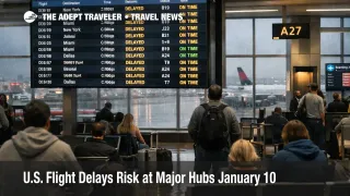
The U.S. flight delays January 10, 2026 risk is less about a single nationwide shutdown and more about multiple regional constraints that can stack into a late day network spill.
In its current operations plan for January 10, 2026, the FAA Command Center flagged low ceilings around Ronald Reagan Washington National Airport (DCA), thunderstorms around Hartsfield Jackson Atlanta International Airport (ATL), and rain or snow risk around Detroit Metropolitan Wayne County Airport (DTW), Minneapolis St Paul International Airport (MSP), Chicago O Hare International Airport (ORD), and Chicago Midway Airport (MDW). The same planning outlook also kept the door open to delay programs later in the day at Chicago O Hare and Midway, Charlotte Douglas International Airport (CLT), and Atlanta, depending on how weather evolves through the peak banks.
At the time of the FAA public status snapshots, several hubs still showed broadly normal conditions, which is exactly what makes these setups tricky for travelers. ATL was posted as on time on the FAA airport status page, even as the wider planning picture was watching storms nearby. DCA also showed on time status with rain and fog or mist reported, a combination that can deteriorate quickly when ceilings and visibility tighten on approach. ORD's real time status page showed only minor delays at the time of the snapshot, but the FAA planning view still put the Chicago area in the weather impacted bucket for later.
The weather backdrop supports that caution. The National Weather Service Weather Prediction Center discussed lingering heavy rainfall and severe weather over parts of the southern Appalachians and the Southeast on January 10, 2026, which aligns with the FAA's thunderstorm driven constraint focus across portions of the Southeast flow.
Who Is Affected
The primary exposure is travelers whose itineraries depend on same day connectivity through the big hubs that redistribute traffic for entire regions. When a hub like Atlanta slows for thunderstorms, or when Washington area approaches slow for low ceilings, the FAA typically meters inbound demand to avoid excessive airborne holding. That metering often shows up as gate holds at your origin airport, sometimes hours away from the weather, which can strand you away from a rebooking counter while alternative seats disappear.
Chicago, Detroit, and Minneapolis St Paul matter because winter precipitation does not have to be extreme to reduce throughput. Light rain mixed with snow can lengthen braking action checks, increase spacing, and slow taxi flows, and it can also lengthen turn times when deicing and ramp constraints begin to bite. The first order effect is slower departures and late arrivals at the impacted airports. The second order ripple is that aircraft scheduled to continue onward often arrive late to their next segment, crews burn duty time, and an afternoon delay turns into an evening cancellation when the schedule loses slack.
Travelers with short connections, last flights of the day, cruise and resort transfer windows, or hard start commitments are the group most likely to feel the pain. If your itinerary includes a tight domestic connection through a weather flagged hub, the probability of a miss rises sharply once arrival rates step down, because the connection buffer you thought you had can disappear before your first flight even pushes back.
What Travelers Should Do
Take immediate control of the easy levers. Check your airline app for same day confirmed changes, same day standby, and waiver language tied to ATL, DCA, ORD, MSP, and nearby airports that share the same weather system. If you can move to an earlier departure, or switch to a routing with more same day frequency on the same ticket, you usually buy more recovery options before the system starts rationing seats.
Use decision thresholds instead of waiting on hope. Waiting is reasonable when you have multiple later alternatives and your downstream plans can flex. It stops being reasonable when your connection drops below your personal cutoff, when you are on the last practical flight to protect a cruise embarkation or a prepaid check in window, or when your inbound aircraft is already running late and the hub is trending worse.
Over the next 24 to 72 hours, monitor three signals that typically lead the traveler experience. First, watch whether your hub airport status shifts from on time into rising arrival delays or a delay program, because that usually means spacing has already increased. Second, watch whether the same city pair starts showing targeted airline waivers, because carriers often publish those before the worst bank impacts. Third, track your inbound aircraft and any aircraft swap notices, because a late inbound is one of the fastest ways to predict you will depart late even if the weather is clearing at your origin.
How It Works
Air traffic control, ATC, is a capacity balancing system, and most big delay days are demand management rather than chaos. When ceilings drop, visibility tightens, or thunderstorms sit near arrival corridors, controllers increase spacing between aircraft. That reduces how many arrivals an airport can accept each hour, so the FAA Command Center meters departures bound for that airport to keep aircraft from stacking in holding patterns. That is why a constraint at Atlanta can produce delayed departures in cities nowhere near Georgia, and why a low ceiling day near Washington DC can ripple into missed onward connections through the entire Northeast corridor.
Those first order airport effects propagate into at least two other travel layers quickly. Airline networks run on rotations, one late arrival becomes the next late departure, and crews can time out when multiple small delays accumulate. On the ground, missed connections push travelers into last minute hotel stays, tighten rental car pickup windows, and compress road transfer timing, especially for late arrivals that miss the last shuttle or train options. Even when the weather improves, the recovery period can extend into the next bank because aircraft and crews are not where the schedule expected them to be.
For context on how similar setups have played out in recent days, compare the pattern to U.S. Flight Delays Risk at Major Hubs January 9 and keep airport side capacity constraints in view via FAA Runway Closures at US Airports Raise Delay Risk.