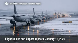
Flight Delays and Airport Impacts: January 16, 2026
Air traffic planners are flagging a winter pattern that can tighten capacity across the Midwest, the Northeast, and key connection hubs today. Travelers are most exposed if their itinerary touches Chicago O'Hare International Airport (ORD), Chicago Midway International Airport (MDW), Seattle Tacoma International Airport (SEA), or the New York area, where low ceilings, snow, and wind can force lower arrival rates. The practical move is to protect connection time now, watch for FAA traffic management initiatives as peak banks build, and switch to earlier routings if your plan has little slack.
The traveler facing change is simple, U.S. flight delays January 16 are more likely where snow, low clouds, and wind reduce how many arrivals hubs can accept per hour, which pushes delays back to your departure airport through metering.
Today's FAA operations plan specifically calls out snow at the Chicago and Minneapolis hubs, low ceilings at Seattle, and wind constraints that can affect the Northeast corridor and several Florida markets. It also keeps the door open for ground stop or delay programs at the Chicago airports after midday, and later in the day for the Newark area and Teterboro.
Who Is Affected
Chicago connections are the highest risk because the FAA has already flagged reduced flexibility in the Chicago Center flow picture. A Command Center advisory notes extended flight plan drop times for Chicago Center (ZAU) due to snow, which is a signal that constraints can show up as earlier departure holds and wider reroutes as the system tries to stay stable.
If you are flying into Chicago O'Hare, the FAA's airport status page shows a traffic management program tied to weather and snow ice for arrivals, which is the kind of setup that can turn modest delays into a bank wide problem once arrival clusters begin competing for gates and deicing slots.
Seattle is a different failure mode. The airport status page can look relatively calm early, but low ceilings are explicitly listed as a terminal constraint in the FAA plan, and ceiling driven arrival rate cuts tend to break tight connections late, when there is less schedule slack and fewer reaccommodation options.
The Northeast and Mid Atlantic are also coupled today. The FAA plan lists wind constraints spanning the New York area and several major hubs in the Philadelphia, Washington, Charlotte, and Florida orbit, which matters because even a small arrival rate reduction at a hub pushes delays outward to dozens of feeder cities.
Even if your destination looks fine, you can still get delayed at origin because the FAA generally prefers holding aircraft on the ground to avoid excessive airborne holding in constrained airspace and terminal areas. When reroutes are active, you can also see longer flight times and missed connection windows, such as today's required routing for certain flows through the Washington Center constrained area.
For continuity on how Chicago disruptions have behaved this week, see Flight Delays and Airport Impacts: Jan 15, 2026 and Chicago O'Hare Ground Stop Delays Flights Jan 14, 2026.
What Travelers Should Do
Start with immediate buffers that actually reduce risk. If you are connecting through Chicago O'Hare, Chicago Midway, Seattle Tacoma, or the New York area, look for earlier departures, longer connections, and same day alternates that avoid the most weather sensitive banks. For Chicago arrivals in particular, assume metering can show up first as a delayed push at your origin, not necessarily as chaos on the destination airport monitor.
Use decision thresholds for rebooking versus waiting. If your connection is short [especially under about 90 minutes at a hub], or if your onward segment is the last reasonable flight to a smaller city, proactive changes usually beat gambling on a perfect recovery once snow and deicing cycles start stacking. If the FAA escalates from "possible" to active initiatives for ORD or MDW, that is the point where switching to an earlier routing, or a different hub, tends to outperform waiting for the same bank to recover.
Over the next 24 to 72 hours, monitor three things. First, whether additional Chicago flow constraints persist, including advisories that signal reduced flexibility for ZAU. Second, whether SEA ceiling issues extend into later banks, because that is when missed connections and crew duty time problems tend to surface. Third, watch for broader reroute activity that lengthens flight times on the East Coast and Southeast corridors, because that can quietly turn "on time enough" into a missed connection.
Background
The FAA Command Center manages demand when weather, staffing, or airspace constraints reduce capacity. The most traveler visible tools are ground delay programs and ground stops, which hold flights at their departure airports to keep arrival flows safe and manageable at the constrained destination. That is why your first sign of trouble is often a delayed departure from a clear sky origin, because the constraint is downstream at a hub, a center, or a route structure.
Winter patterns propagate in layers. First order effects happen at the source, snow and snow ice reduce braking action, slow snow removal, lengthen deicing queues, and reduce arrival rates at hubs like Chicago O'Hare and Chicago Midway. Second order effects then spread to connections and crew flow, late inbound aircraft miss their next departure slot, gates fill, turns lengthen, and crews run out of duty time margin, which increases cancellation risk late in the day. A third layer often shows up as reroutes, when airspace constraints or thunderstorm corridors force longer routings and meter flows through specific fixes, which adds block time and strains tight connection plans even if the destination itself is operating acceptably.
Even on days when "general delays" look manageable at several airports, planning advisories matter because they identify where the system is most likely to deteriorate once demand ramps up. Today's plan highlights exactly that, snow around the Chicago and Minneapolis region, low ceilings around Seattle, and wind driven sensitivity across the Northeast and Florida flows, with possible initiatives listed for the Chicago airports, Aspen and Eagle County, and later for the Newark area and Teterboro.
Sources
- Current Operations Plan Advisory (ATCSCC ADVZY 034 DCC 01/16/2026)
- The Most Recent ATCSCC Advisory (ATCSCC ADVZY 040 ZAU 01/16/2026)
- Chicago OHare International Airport (ORD) Real time Status
- Seattle Tacoma International Airport (SEA) Real time Status
- Minneapolis St Paul International Wold Chamberlain Airport (MSP) Real time Status
- Newark International Airport (EWR) Real time Status
- Current Reroutes