Geomagnetic Storm North America GPS and Comms Risk
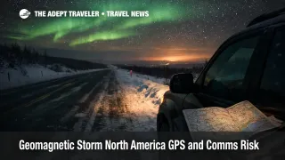
NOAA's Space Weather Prediction Center says severe G4 geomagnetic storm conditions were reached as a coronal mass ejection arrived, increasing the odds of intermittent satellite and navigation issues across North America. The highest practical travel risk sits in the far north, including Alaska, northern Canada, and Greenland, plus the northern tier of U.S. states where aurora visibility can expand during stronger intervals. Travelers do not need to panic rebook, but they should build redundancy for navigation and communications, especially for polar flights, offshore work, and remote winter driving where GPS timing and comms gaps can quickly become a logistics problem.
The change that matters for trip planning is that a geomagnetic storm can temporarily disturb the ionosphere, which is the layer of the atmosphere that GNSS signals pass through. When the ionosphere becomes more turbulent, receivers can lose lock, position accuracy can degrade, and timing can wobble. In practical travel terms, the same event that makes auroras more widespread can also produce intermittent GPS oddities and unreliable communications paths, particularly at higher latitudes and on routes that depend on HF radio.
Who Is Affected
Travelers most exposed are those operating or moving through high latitude and remote regions, including road trippers in northern states, backcountry travelers, winter drivers on long rural highways, and anyone relying on satellite messengers for safety check ins. This also reaches offshore operations and remote worksites where satellite connectivity and GNSS timing support logistics, positioning, and comms.
Aviation impacts tend to be more procedural than dramatic for most passengers, but they can be meaningful in the far north. Airlines, dispatch teams, and air traffic providers may shift to more conservative routing and communications practices on polar and near polar sectors when space weather risk rises, because GNSS performance and HF propagation can be less reliable at the same time. The first order effect is the potential for navigation and comms anomalies in the operating environment. The second order ripple is that small operational choices, like a reroute to stay out of the highest latitudes, or extra spacing and comms checks, can cascade into later arrivals that disrupt onward connections, tighten hotel check in timelines, and reduce flexibility for same day reaccommodation when schedules are already thin.
Travelers chasing aurora in Canada and the northern United States face a different ripple. A strong aurora forecast can shift demand quickly into small markets, which can tighten rental car supply, lift last minute room rates, and overload roadside assistance capacity if a spike of visitors drives rural roads in bad weather while leaning heavily on phone navigation.
For background on how space weather has shown up in travel operations before, see G3 Geomagnetic Storm North America Flights December 9, 2025. For a deeper explainer on why modern travel systems are increasingly sensitive to space driven glitches, see Cosmic Rays, Bit Flips, and the Airbus A320 "Icarus" Recall.
What Travelers Should Do
Travelers in remote or northern areas should assume intermittent navigation weirdness is possible, and build a simple, low friction redundancy stack. Download offline maps for the full corridor, plus alternate routes, before leaving reliable coverage. Write down key waypoints, highway numbers, and fuel stops on paper, and keep a conservative fuel plan so a missed turn does not become a range problem in cold conditions.
For flight travelers, the decision threshold is mostly about trip criticality and routing latitude. If an itinerary includes polar or far north segments, tight same day connections at small airports, or separate tickets that depend on on time performance, it is reasonable to rebook to a less tight connection or a lower latitude routing if that option is available at low cost. If travel is on standard mid latitude domestic routes, it is usually better to watch airline updates rather than proactively changing plans, because airlines can absorb small procedural adjustments without visible disruption for most passengers.
Over the next 24 to 72 hours, monitor NOAA SWPC alerts for storm intensity changes, and treat any worsening as a prompt to widen buffers, not as a signal to cancel automatically. In apps, watch for repeated location jumps, delayed turn prompts, or inconsistent compass behavior, and do not assume the phone is right if the road signage disagrees. If traveling with a group in rural areas, agree on simple meet up rules, a time based check in cadence, and one fallback rendezvous point in case messaging fails.
How It Works
A geomagnetic storm is driven by solar activity, often a coronal mass ejection, that interacts with Earth's magnetic field and energizes the upper atmosphere. The ionosphere becomes more variable, which matters because GNSS signals such as GPS must pass through it. When conditions are disturbed, receivers can experience scintillation, which can reduce accuracy or break lock, and timing dependent systems can see more noise. At the same time, HF radio propagation can degrade in polar regions, which matters for long haul aviation and high latitude operations that still rely on HF as a primary or backup communications path.
In travel systems, that physical disturbance propagates through operations in layers. At the source layer, navigation performance and radio propagation can become less predictable. In the flight planning layer, dispatchers may choose routes, altitudes, or comms procedures that reduce exposure, which can add minutes and increase complexity. In the network layer, those minutes can push an aircraft off a gate, compress connection windows, and increase downstream misconnect risk, especially where there are few later flights to recover passengers. On the ground transport layer, travelers leaning on phone navigation in rural corridors may make wrong turns or arrive later to timed reservations, and in winter conditions that can raise roadside assistance demand and strain small town services during peak aurora nights.
Sources
- Update: G4 (Severe) Geomagnetic Storm Alert Issued
- G4 (Severe) Geomagnetic Storm Levels Reached 19 Jan, 2026
- G4 (Severe) Geomagnetic Storm Watch for 20 January UTC-Day
- S4 (Severe) Solar Radiation Storm in Progress, January 19th, 2026
- NOAA Space Weather Scales
- Space Weather and GPS Systems
- Aurora Dashboard (Experimental)
- Parts of the US could see northern lights Monday