Winter Storm Fern US Flights, Waivers Expand Jan 23
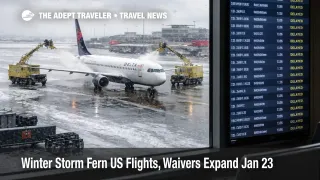
A sprawling winter storm pattern, widely labeled Winter Storm Fern by broadcast and commercial weather outlets, is pushing snow, sleet, freezing rain, and dangerous cold across a wide swath of the central and eastern United States. Travelers are affected first where ice overlaps major connecting hubs and where airport access depends on highways that do not recover quickly once glazing starts. The practical move is to use airline waivers early, avoid tight connections during the peak window, and build enough buffer that one delayed deicing cycle does not break the entire trip.
The Winter Storm Fern US flights setup matters because the storm is arriving with enough cold behind it to slow recovery, which can turn a weekend disruption into a rolling Monday and Tuesday schedule problem.
Airlines are already moving into irregular operations posture. Delta has announced proactive cancellations at select airports and expanded waivers so customers can shift travel without fees in affected markets. Other major carriers, including American and Southwest, have also published storm advisories and change policies that cover broad regions and multiple travel days, which is your best signal that staffing, aircraft positioning, and airport surface operations are expected to be constrained, not just your local neighborhood forecast.
For continuity, travelers can compare the earlier outlook in US Winter Storm Flights, Delays Likely Jan 24 to 28. The key update now is that the airline waiver footprint is broader and the operational response, including pre cancels in parts of the South, has already started.
Who Is Affected
Travelers connecting through the biggest hubs are exposed even if their origin or destination looks clear on the map. When freezing rain hits the South, ramp safety rules can slow turns, and deicing queues can stretch, which is how a manageable forecast becomes a wave of missed connections. American's advisory list for the storm spans many Southern and Mid Atlantic airports, and those are the same places that feed the national network with high frequency short haul flying.
The second group is anyone with hard arrival deadlines, including cruise embarkations, prepaid tours, weddings, or same day business meetings. Winter storms break itineraries in two ways, the flight segment, and the ground segment. Even when a runway remains open, airport access can fail when bridges, overpasses, and untreated secondary roads ice over, and that causes missed check in windows and missed flights that never appear as a pure aviation problem.
The third group is travelers far from the storm footprint who are flying on aircraft and crews that rotate through affected hubs. When the FAA meters arrivals into constrained airports to prevent unsafe airborne holding, that metering often shows up as departure delays from airports that have clear weather. The ripple can reach the West Coast and Mountain hubs because the network is trying to keep aircraft and crews legal while reflowing around the storm.
Rail and road travelers are also in the blast radius. Freight rail operators have warned of network disruption in central corridors, and passenger rail can face frozen switches and speed restrictions during extreme cold. Those ground disruptions push more stranded demand into airport hotels and last minute one way car rentals, tightening availability and raising the cost of recovery choices.
What Travelers Should Do
If your itinerary touches the South, the Mid Atlantic, or the Northeast between Friday, January 23, 2026, and Monday, January 26, 2026, treat this as a proactive change window, not a wait and see situation. Use your airline's travel alert page to confirm whether your specific airport is included, then move early while the seat map still has options, especially if you are trying to protect a same day connection through a hub.
Use a decision threshold for rebooking versus waiting. If freezing rain is forecast within 24 to 36 hours of your departure window at your origin, your connection hub, or the highway corridor you must drive to reach the airport, rebooking is usually safer than showing up and hoping the operation holds. If your itinerary is on separate tickets, or you have a must arrive deadline, raise the threshold again, and do not rely on the last flight of the day.
Over the next 24 to 72 hours, monitor three layers that change fast during winter operations: National Weather Service warnings for your counties, airline travel alerts for updated waiver dates and airport lists, and FAA system status for airport event impacts and traffic management initiatives. If your flight cancels and you decide not to travel, DOT refund guidance is clear that refunds are owed in cancellation scenarios when you decline alternative travel, even when the trigger is weather, so do not assume you must accept credit if a cash refund better fits your plan.
For real time airport disruption context and pattern matching, Flight Delays and Airport Impacts: January 22, 2026 shows how quickly multi region constraints can stack, even before the main winter storm core arrives.
Background
Winter storms disrupt travel through surface capacity loss and through network fragility after the first cancellations. At the source, snow and ice reduce the number of arrivals an airport can accept per hour because braking action, visibility, and runway configuration limits force wider spacing on approaches and longer times on the ground. Deicing adds minutes per departure, and those minutes compound into gate conflicts when several banks are trying to push at once.
Freezing rain is the operational wild card in the South and parts of the Mid Atlantic. A thin glaze can close ramps for safety, slow baggage and fueling, and make ground equipment unreliable, even while the runway remains technically available. That mismatch is why storms with modest precipitation can still trigger large cancellation counts, the constraint is the turn, not the takeoff.
Second order effects are what most travelers experience. When a hub cancels a bank, aircraft are left out of position for later segments, crews run into duty limits, and the next day starts short on both planes and staff. The FAA then meters traffic into still constrained airports to prevent overload, which spreads delays to departure airports nationwide. On the ground, road icing and extreme cold can block airport access and disrupt rail schedules, increasing last minute hotel demand near hubs and making it harder to recover if you miss a connection.
Sources
- Freezing temps, heavy snow expected for millions of people in central and eastern US this weekend
- US airlines issue travel waivers as winter storm threatens widespread disruptions
- Winter Storm Fern update: Delta cancels flights in five states, expands waivers for customers to adjust travel | Delta News Hub
- Travel Advisories & Alerts | Southwest Airlines
- Travel alerts - Travel information - American Airlines
- Winter Storm Severity Index Web Display
- National Airspace System
- Refunds | US Department of Transportation