UK Snow Warnings Disrupt Rail and Ferries Feb 3
Met Office weather warnings spanning February 3, 2026, and February 4, 2026 are raising the odds of rail cancellations, slower road journeys, and ferry disruption across multiple UK regions. Snow is forecast to affect parts of southern England from 0000 on Tuesday, February 3, 2026, through 1500 on Wednesday, February 4, 2026, with the warning covering areas including Hampshire, the Isle of Wight, Portsmouth, Southampton, Dorset, Somerset, and Wiltshire. In Scotland, separate snow and snow and ice warnings cover large parts of the country, including island areas, with the most exposed routes facing compounding risk from wind, drifting snow, and reduced visibility.
Travelers are also dealing with a wet ground setup that turns additional rain into transport disruption quickly. Environment Agency data shows numerous flood warnings and a larger number of flood alerts active in England on February 3, 2026, which matters for rail corridors that run close to rivers, low lying approaches to stations, and road links that become unreliable when standing water returns after dark. In Wales, Natural Resources Wales flood warnings and coastal alerts add sensitivity for routes that rely on coastal roads and ferry terminals exposed to swell and spray.
Who Is Affected
Rail passengers are affected first, especially anyone depending on a tight chain, such as a local train into a long distance service, then a road transfer to an airport. National Rail has an active example of how this plays out, reporting flooding has closed Great Western Railway lines between Exeter St Davids and Okehampton and Barnstaple, with cancellations and revised services, and disruption expected into Wednesday, February 4, 2026. Even if your route is not closed, wintry precipitation tends to create speed restrictions, platform changes, and short-notice timetable edits that can break short connections.
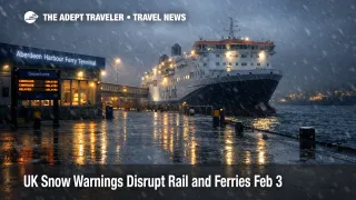
Ferry passengers are most exposed on island links and west and north coast crossings where operators have limited spare capacity and fewer same day alternatives. NorthLink has posted an operational warning that forecasts indicate possible disruption from Tuesday, February 3, 2026, onward, which is the kind of signal that often precedes cancellations on the most weather sensitive sailings. In Scotland, Caledonian MacBrayne's status guidance also emphasizes that delays, diversions, and cancellations can occur during adverse conditions, and that route-by-route checks are essential before leaving for the terminal.
Air travelers are affected indirectly, because the failure point is rarely the flight itself, it is getting to the airport on time when the ground network loses slack. If your itinerary depends on a same day positioning move, treat it as a higher risk day, especially for early departures when roads can be icy before treatment cycles catch up and when rail recovery capacity is thinnest. London Heathrow Airport (LHR) and other major hubs can still operate while surface access degrades, which shifts risk onto travelers who planned minimum transfer times.
What Travelers Should Do
Start by protecting the parts of your trip that have hard cutoffs. On February 3, 2026, and February 4, 2026, check your train and sailing status before you leave for the station or terminal, then immediately warn any downstream provider that you may be late, including hotels, tours, and ground transfer services. If you are connecting to international rail, build extra time for station entry and boarding processes, and keep a viable later departure in mind in case your first leg is cancelled, including cross channel plans where you might otherwise assume the network will self-correct, as seen in recent disruption patterns like Paris Gare du Nord Eurostar Delays Feb 2.
Use clear decision thresholds for rebooking versus waiting. If your first leg is cancelled and the next workable option would push you inside the minimum check-in window for a flight, or inside the last viable connection for the day, move early rather than waiting for incremental updates. For many travelers, the practical threshold is simple, if you cannot still arrive at the airport or terminal at least two to three hours earlier than you normally would on a calm day, you should shift to a later departure, add an overnight buffer near the hub, or reroute to a mode less exposed to the specific warning in your corridor.
Over the next 24 to 72 hours, monitor signals that indicate whether disruption is stabilizing or worsening. Weather warnings can be updated, expanded, or reduced, and flooding risk can persist after rainfall stops because saturated ground and high water levels keep vulnerable sections at risk. Watch for new operator incident pages, escalating route status levels, and any note that disruption is expected to continue into the following day, as with the current Great Western Railway flooding closure. If your trip also involves a UK entry compliance check later this month, do not let weather disruption compress your pre-travel admin time, and keep your documentation ready for rebooked departures, as outlined in UK ETA Feb 25 Boarding Rule, Avoid Denied Boarding.
How It Works
Met Office warnings matter to travel because they describe the conditions that reduce network throughput, not just unpleasant weather. Snow and ice increase stopping distances and reduce traction, which slows road speeds, increases collision risk, and makes schedules less predictable. On rail, wintry precipitation can trigger speed restrictions, points issues, and crew displacement when services are cancelled in one area and staff cannot reposition easily, which is why a local problem can cascade into missed long distance connections.
Flooding adds a different failure mode, it closes or constrains specific low lying segments and station approaches, and it tends to recur after dark as water drains slowly and temperatures drop. That is why a wet ground setup with many active flood warnings and alerts can turn additional rainfall into transport disruption quickly, even if the rain itself does not look extreme at street level. In practice, the first order effect is cancelled trains, delayed buses, and longer taxi journeys, then the second order ripple shows up as missed flight connections, missed ferries, and unplanned hotel nights near hubs because same day recovery inventory disappears.
Ferry disruption compounds quickly because there are fewer substitute departures and because road access to ports can be affected by the same wind, spray, ice, or flooding. When an operator issues an early disruption warning, it is often because forecast confidence is rising and because operational constraints, like safe berthing limits and crew duty windows, leave little room to "run late" and still complete a round trip.
Sources
- UK weather warnings, Met Office
- Incident: GWR Weather, National Rail
- Flood alerts and warnings, Environment Agency (GOV.UK)
- Flood warnings and alerts, Natural Resources Wales
- Ops News, NorthLink Ferries
- Passenger disruption, ScotRail
- Stay updated on your sailing status, Caledonian MacBrayne
- Weather warnings, Traffic Scotland