Flight Delays and Airport Impacts: February 9, 2026
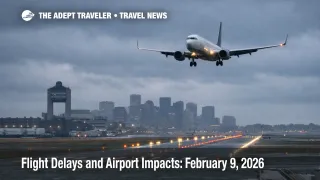
Gusty winds and low cloud ceilings are the main drivers of expected U.S. aviation friction on February 9, 2026, with the Federal Aviation Administration flagging Boston and the New York area as the most sensitive to delays. Travelers connecting through Boston Logan International Airport (BOS) and the New York complex, Newark Liberty International Airport (EWR), John F. Kennedy International Airport (JFK), and LaGuardia Airport (LGA), are the most exposed because even small arrival rate cuts quickly cascade into missed connections and end of day rebooking bottlenecks. Plan for longer connections and keep your schedule flexible, especially if your itinerary depends on a tight hub transfer or a last departure of the night.
The Flight delays February 9 2026 setup is a targeted hub capacity risk driven by winds in the Northeast and low clouds at several large airports, which can translate into rolling delays well beyond the weather footprint.
Who Is Affected
Northeast itineraries are first in line for disruption if winds force spacing, runway configuration changes, or metering into Boston and the New York area airports. The FAA's daily outlook specifically calls out gusty winds as a delay driver for Boston and for the New York area, which matters because these hubs sit on dense connection flows that pull in aircraft from across the country.
The FAA also flags low clouds as a potential throughput constraint at William P. Hobby Airport (HOU), Salt Lake City International Airport (SLC), San Francisco International Airport (SFO), and Seattle Tacoma International Airport (SEA). Low ceilings do not automatically mean major delays, but they increase the odds of instrument arrival rates, longer spacing, and fewer usable arrival slots during peak banks, especially when paired with runway flow constraints or convective bands elsewhere.
A key nuance for February 9 is that FAA airport status snapshots showed these specific airports as on time around late morning local time, which is consistent with a day where disruption risk builds later as winds peak, ceiling layers lower, or bank demand rises. Treat "on time" as a momentary state, not a guarantee for your departure window.
What Travelers Should Do
If you are flying through Boston Logan or the New York area, protect your itinerary first, not the airline's published minimum connection time. Build buffer for security, gate changes, and taxi delays, and if your connection is tight, move to an earlier inbound flight while seats are still open. If you are checking bags, assume you have less margin, and prioritize itineraries with longer connection windows.
Use a clear decision threshold so you do not drift into the worst part of the day without options. If you see your inbound flight slipping and your connection falls under 90 minutes at BOS, EWR, JFK, or LGA, start rebooking immediately rather than waiting for an official misconnect, because reaccommodation inventory thins fast once a hub starts metering arrivals. If you are on separate tickets, treat this as a rebook now situation, because the system will not automatically protect the onward segment.
Over the next 24 to 72 hours, monitor three signals, the FAA daily outlook, FAA airport status for your hub, and any Air Traffic Control System Command Center advisories that mention flow programs or routing initiatives into the Northeast or your specific airport. If your trip includes a cruise embarkation, a fixed event, or a prepaid tour, consider shifting that commitment later in the day, or moving travel to February 10, 2026, because weather driven hub delays often compress into missed onward handoffs and forced overnight stays near the airport.
How It Works
Air traffic control, ATC, manages demand to match what airports and airspace can safely handle when winds, low ceilings, or runway constraints reduce throughput. When winds are strong, an airport may need to change runway configuration, slow arrivals to maintain safe spacing, or add arrival miles in trail, which reduces the number of flights that can land per hour. When ceilings are low, instrument approaches and spacing requirements can further reduce acceptance rates, even if the airport remains open and conditions look "fine" from the terminal.
The ripple spreads in two main layers. First order, arrivals into BOS and the New York area get metered, holding aircraft on the ground at their origin or in airborne holding, and that immediately creates departure delays far from the weather because aircraft cannot depart for a saturated destination. Second order, once aircraft arrive late, crews can time out, turns get missed, and downstream legs later in the day inherit the delay even on routes nowhere near the Northeast. The practical result is that a Boston or New York wind day can look like scattered national disruption, with uneven pockets of delay, missed connections at hubs, and hotel inventory compression near airports if cancellations force overnights.
For February 9, the FAA's daily report highlights the risk drivers while the airport status pages provide the rolling operational snapshot. Use both, and assume the peak pain, if it comes, is most likely to show up around banked arrival periods rather than evenly across the day.
For deeper context on why localized constraints can still feel systemwide, see U.S. Air Traffic Control Privatization: Reality Check. For recent comparable travel day patterns, see Flight Delays and Airport Impacts: February 7, 2026 and Flight Delays and Airport Impacts: February 6, 2026.