Malta Red Wind Warning To Disrupt Gozo Ferries
Malta authorities raised the weather alert level for very strong winds across the Maltese Islands, a red warning that often forces ferry operators to slow, reroute, delay, or suspend sailings when sea state and gusts exceed operating limits. The travelers most exposed are anyone planning a Gozo day trip, anyone moving between Malta and Gozo for lodging changes, and anyone chaining a sea crossing to a fixed deadline like a flight, a tour departure, or a timed event. The practical move is to treat every sea leg as conditional through early Friday, February 13, 2026, and to decide in advance when you will stop waiting and switch to an overnight, a different departure time, or a different plan.
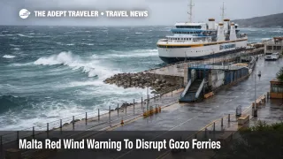
The Malta red wind warning ferries risk is not just a forecast story, it is an operations story. In high wind events, even when sailings continue, schedules can stretch as vessels take less exposed routes and ports meter loading for safety, which is how a routine crossing becomes a terminal queue with poor predictability.
Who Is Affected
Foot passengers and day trippers are affected first because they have the least tolerance for delays, and fast craft products typically hit their wind limits earlier than larger conventional ferries. If you planned to cross for a same day return, the risk is being stuck on the wrong side when the evening sailings thin out or when queues consume the remaining operating window.
Vehicle travelers face a different problem, backlog math. When crossings pause, cars stack at the terminals, and when service resumes, capacity can be effectively rationed by loading speed, safety checks, and the need to run a more protected route. That creates a surge pattern where the first few restarted departures are crowded, and the queue can remain stubborn even after the weather begins to ease.
Travelers connecting to flights are the highest stakes group even if they are not using a ferry to reach an airport directly. A delayed reposition between islands can break hotel check out timing, car return timing, and pre arranged transfers, and it can force last minute rebooking costs if you miss a downstream departure on a separate ticket. The second order ripple shows up in lodging and ground transport, with unplanned extra nights near terminals, taxi scarcity during restart surges, and car rental one way changes when travelers cannot return vehicles as scheduled.
What Travelers Should Do
If you are traveling on February 12 or February 13, 2026, start with a go, no go rule that protects fixed deadlines. If you have a flight, an international connection, or a non movable appointment within the next 12 to 18 hours, treat a same day crossing as a no go unless the operator shows normal operations and you still have a large time cushion. If your plans are flexible, a go decision can be reasonable when services are running, loading is steady, and you can tolerate a long wait without breaking lodging or car commitments.
Set decision thresholds before you leave, because the worst outcome is spending hours in a terminal queue and then losing the rest of the day anyway. A clean threshold is to switch plans if you see repeated delays, a suspension notice, or a queue that is not clearing after a sailing cycle. In practice that means choosing an overnight on the island you are already on, or shifting the crossing to the next safer window rather than trying to brute force a crossing during the strongest winds.
Over the next 24 to 72 hours, monitor operator updates for three signals, resumption language, route changes, and frequency reductions. Resumption tells you whether service is back at all, route changes hint at slower crossings and stretched schedules, and frequency reductions tell you whether the backlog will keep building. If you want a useful comparison for how weather driven ferry disruption can restart unevenly and then surge, see Storm Marta Strait Ferries, Andalusia Roads Still Shut, and for the network effect when one ship or corridor is pinned by weather and schedules restack across days, see Blue Star Ferries Rhodes Sailings Changed Feb 12 to 22.
How It Works
High wind events disrupt ferry systems in layers, and Malta's inter island travel is a concentrated version of the same dynamic seen across the Mediterranean. The first order constraint is safety at the ship and port interface, where wind direction, gusts, and sea state determine whether a vessel can safely depart, approach, and berth. When limits are reached, operators either suspend service, reduce speed, or reroute to more sheltered water, which preserves some continuity but stretches the schedule and reduces effective capacity.
The second order ripple spreads through the rest of the travel stack. Capacity compression creates queues and forces travelers to cluster onto the next operating departures, which then strains taxis, buses, and pickup logistics at both terminals. It also pushes disruptions into hotels and car rentals, because missed crossings produce unplanned overnights, late check ins, and vehicle return changes. Finally, disruption can spill into other sea links, including harbor ferries and international fast craft, because operators share exposure to the same sea conditions and because vessels and crews may be repositioned to recover schedules once the weather eases.