Flight Delays and Airport Impacts: March 9
March 9 flight delays are shaping up as a South and Texas connection risk day, not a nationwide system failure. The FAA's morning operations plan says the Northeast should start in comparatively favorable shape, while low ceilings and visibility affect Charlotte, Atlanta, Tampa, Austin, San Antonio, Seattle, and Los Angeles, and thunderstorms could interfere with traffic flows across multiple Southern airspace centers later in the day. For travelers, that means the bigger risk is not simply a departure delay at one airport, but a late morning through afternoon cascade through Florida, Texas, and the Southeast if you are connecting through those regions.
The key change from Flight Delays and Airport Impacts: March 8 is that the FAA's clearest March 9 stress points are now concentrated in Southern terminal weather, Florida snowbird demand, and a renewed Texas route risk, rather than a broader Northeast drag. The FAA also says no terminal initiatives were active early in the day, but possible ground stops were already on the table for Houston George Bush Intercontinental Airport (IAH) after 1100 a.m. and Tampa International Airport (TPA) after 1200 p.m., which is the sort of early planning flag that can matter more for connection decisions than for nonstop local travelers.
March 9 Flight Delays: What Changed
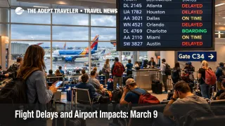
The FAA Command Center's March 9 advisory points to the most important operational split of the day. Washington, D.C., through Boston is expected to begin with comparatively favorable weather and no planned initiatives, but Charlotte Douglas International Airport (CLT), Hartsfield, Jackson Atlanta International Airport (ATL), and Tampa all sit under low ceilings and visibility constraints, while Austin, San Antonio, Seattle, and Los Angeles also appear in the morning terminal constraints list. In plain language, that means the system starts with usable capacity in the Northeast, but less spare room across several Southern and Western nodes if arrivals bunch up or weather deteriorates.
The Texas and Gulf piece matters even more because the FAA separately flags thunderstorms across New York, Jacksonville, Miami, Fort Worth, and Memphis center airspace, plus possible Dallas arrival route limits after 400 p.m. and Houston arrival route limits after 500 p.m. That is how a day that begins looking manageable can still become messy by mid to late afternoon, especially for itineraries that depend on Dallas Fort Worth International Airport (DFW), Dallas Love Field, Houston, Tampa, or South Florida banks to complete the second half of the trip.
Which Travelers Face the Most Disruption
The most exposed travelers on March 9 are not necessarily those departing from the airports with the worst looking morning weather. The bigger exposure is for passengers connecting through Southern hubs on one ticket, because they need two things to work, the first flight, and the onward bank. If storms or low ceilings slow the first segment into Atlanta, Charlotte, Houston, or Tampa, the second order effect is misconnect pressure, tighter rebooking space, and a higher chance of involuntary overnight stays in busy spring travel markets.
Florida travelers should pay particular attention even if local airport status pages still show normal operations early. The FAA explicitly warns that South Florida terminals should see favorable weather but also "moderate snowbird volume," and it says scheduled users may encounter median delays traversing Jacksonville and Miami center airspace. That matters because good local weather does not guarantee smooth flow when heavy seasonal demand and en route constraints combine, especially for passengers heading into or out of Florida on connections rather than nonstop service.
Travelers with flexible nonstop itineraries out of airports that remain on time early, such as IAH, ATL, SEA, CLT, or TPA, still have a better chance of getting out cleanly than passengers on tight same day connections. But that advantage can fade quickly once the FAA moves from "possible" initiatives to active programs, so the margin is real only if travelers use it early.
What Travelers Should Do Now
Travelers flying through Texas, Florida, Atlanta, or Charlotte on March 9 should check whether they are still on a viable connection, not just whether the first leg is technically operating. A same day itinerary with less than about 90 minutes at a Southern hub is materially weaker on a day like this, because low ceilings, flow controls, and thunderstorm routing changes tend to eat schedule padding in small chunks before the real disruption becomes obvious. Travelers who can switch to earlier departures, longer layovers, or nonstop alternatives should weigh doing so before afternoon route programs harden.
For Tampa and Houston in particular, the FAA's planning flags are a warning to stay in airline app mode throughout the late morning. A possible ground stop is not the same as an active stop, but once one becomes active, the practical result is that upstream departures get held at origin and connection math changes fast. Travelers heading to the airport without checking for updated departure times, gate shifts, or rebooking options are taking avoidable risk.
Over the next 24 hours, watch for the same factors that are already in the FAA plan, Southern thunderstorms, Florida volume pressure, and route restrictions into Dallas and Houston. Travelers who do not need to connect should generally stay with nonstop plans if those remain available. Travelers who do need to connect should consider the broader system context as well, because U.S. Shutdown Risk Raises Spring Break Airport Strain shows how even modest staffing or flow friction can spread faster in a high demand March environment. For a wider structural view of why U.S. delay recovery remains fragile, U.S. Air Traffic Control Privatization: Reality Check is useful background.
Why the Disruption Spreads Through Travel
The mechanism on March 9 is straightforward. Low ceilings and visibility reduce arrival efficiency at several airports, while thunderstorm constraints in key airspace centers limit how cleanly traffic can move between regions. At the same time, spring and snowbird demand keeps the schedule dense, which means there is less slack in aircraft rotations, gate availability, and crew timing once delays start to stack.
That is why the first order effect, slower arrivals or possible departure holds at airports like Tampa or Houston, often becomes a second order problem elsewhere. A late inbound aircraft can break an onward departure bank, push a crew closer to duty limits, or strand passengers in hubs where rebooking inventory is already tight. The FAA's March 9 plan also includes ongoing operational limitations such as runway, taxiway, and equipment issues at airports including Chicago O'Hare International Airport (ORD), Orlando International Airport (MCO), Washington Dulles International Airport (IAD), DFW, and IAH, which reduces the system's flexibility even before weather adds pressure.
That combination is why March 9 looks more like a selective network stress day than a headline grabbing shutdown. Travelers who treat it as normal because their origin airport still says "on time" may get caught by the second half of the problem. Travelers who build in buffer, protect connections, and monitor Houston, Tampa, Dallas, Atlanta, Charlotte, and Florida flows through the afternoon should have a better shot at preserving the trip.
Sources
- Current Operations Plan Advisory, FAA
- ATL Airport Status, FAA
- CLT Airport Status, FAA
- AUS Airport Status, FAA
- SAT Airport Status, FAA
- IAH Airport Status, FAA
- SEA Airport Status, FAA
- TPA Airport Status, FAA
- Flight Delays and Airport Impacts: March 8
- U.S. Shutdown Risk Raises Spring Break Airport Strain
- U.S. Air Traffic Control Privatization: Reality Check