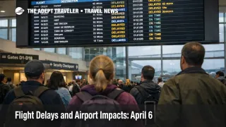
Flight Delays and Airport Impacts: April 6
April 6 flight delays are shaping up as a San Francisco and Florida problem first, with Houston and parts of the Northeast sitting in the next risk tier. The Federal Aviation Administration's current April 6 operations plan shows San Francisco International Airport (SFO) as a probable ground stop or delay program later in the day, while Orlando International Airport (MCO), Miami International Airport (MIA), Fort Lauderdale Hollywood International Airport (FLL), Palm Beach International Airport (PBI), and Houston George Bush Intercontinental Airport (IAH) are also flagged for possible terminal initiatives as weather and routing pressure build. Travelers with short same day connections, Bay Area arrivals, or late day Florida itineraries should protect buffer early.
April 6 Flight Delays: What Changed
What changed on Monday, April 6, 2026 is that the FAA's live planning picture is centered less on one airport already in deep trouble and more on a set of linked risk zones that can harden as the day progresses. The agency's operations plan lists wind constraints for Boston Logan International Airport (BOS), the New York approach structure, and Philadelphia International Airport (PHL), mixed precipitation at Detroit Metropolitan Wayne County Airport (DTW), thunderstorms near Orlando, and storms or low ceilings across the South Florida airport cluster. It also warns of thunderstorm driven closures on key ocean and Gulf routes, with additional route closures possible later today.
San Francisco is the clearest named watchpoint because today's probable FAA program lands on top of an already weaker arrival system. The FAA said on March 31 that SFO would face delays during a six month runway repaving project and a new safety measure that bans side by side approaches on its parallel east west runways in clear weather. Reuters reported those combined limits cut the airport's maximum arrival rate from 54 to 36 flights per hour and pushed expected delays to about one quarter of arriving flights by at least 30 minutes.
Which Travelers Face the Most Airport Impact
The most exposed travelers are passengers arriving into SFO, connecting across California after a Bay Area arrival, or flying into Florida during the late afternoon and evening push. SFO matters more than a normal weather watch because its margin for recovery is already reduced. A modest weather slowdown at an unconstrained airport can stay local. At SFO, the same slowdown can stretch into longer arrival holds, late inbound aircraft, weaker turn times, and fewer clean same day fixes. In an earlier Adept Traveler article, SFO Landing Restrictions Cut Arrivals Through October 2, that structural risk was already clear before today's added pressure.
Florida bound travelers are the other group that should pay close attention. The FAA plan shows possible ground stops later today for Orlando and the South Florida airport group, while en route constraints are already active or possible on Florida oriented flows from the Northeast and Midwest. That means the problem is not only a local thunderstorm at the destination. It is a network routing problem that can delay departures far from Florida because aircraft need managed paths into the region.
Houston and the Northeast are the secondary pressure points. The FAA flagged IAH for a possible ground stop or delay program after 3:00 p.m. Zulu because wind could reduce arrival rates, and it separately listed wind related terminal constraints for Boston, New York area traffic, and Philadelphia. Those airports are not all in active disruption yet, but they matter because they feed dense connection banks. Once SFO, Florida, Houston, and East Coast routing all begin pulling on the same national system, short layovers and last flight of the day itineraries become much weaker bets.
What Travelers Should Do Now
Treat April 6 as a protect the itinerary day, not a panic day. If you are heading into SFO or connecting to or from Florida later today, check the inbound aircraft for your flight, not only your own departure time. That is often the earliest sign that a day with only light posted delay averages is starting to slip. If your trip includes a cruise embarkation, prepaid transfer, timed meeting, or the only practical connection of the day, buy time now instead of waiting for the airline to formalize the delay.
Rebooking early makes the most sense for travelers with a hard failure point. That includes short domestic connections, long haul onward flights, family itineraries, or any trip landing late into SFO or Florida. Waiting is more defensible if you are on an early nonstop, have multiple later backups, and can absorb a one to two hour slip without breaking the rest of the trip. The next decision point is simple, if losing 60 to 90 minutes would collapse the day, the FAA setup already justifies adding buffer or changing airports.
For travelers who just want broader pattern context, In an earlier Adept Traveler article, Flight Delays and Airport Impacts: April 5, the main pressure point was New York. Today's pattern is different. The larger risk is a west plus southeast spread, with San Francisco's structural limits and Florida route closures creating a broader late day recovery problem. Travelers who want deeper system context can also read U.S. Air Traffic Control Privatization: Reality Check.
Why Today's Delay Risk Can Spread Later
The mechanism is straightforward. Weather lowers the number of aircraft that can safely arrive at or move through certain airports and corridors in a given hour. The FAA responds with route closures, traffic metering, possible ground delay programs, and, when needed, ground stops. First order, that slows departures and arrivals at the affected airport. Second order, it delays inbound aircraft for later flights, compresses crew timing, weakens gate availability, and reduces the number of seats left for same day recovery.
That propagation risk is higher at SFO than at many other hubs right now because the airport is operating under both a temporary runway project and a permanent arrival rule change. Reuters reported that the FAA does not plan to lift the side by side approach restriction once the runway repaving is complete, which means SFO is not simply dealing with a short burst of construction friction. It is operating with a lower ceiling that makes today's probable delay program more serious for travelers than the same weather pattern would be at a less constrained airport.
What happens next depends on whether today's planned programs switch on and how long the thunderstorm route closures last. If Florida routing stabilizes and SFO avoids a long lived program, the system can still recover before the final evening banks. If both zones tighten at once, the damage will show up less as one dramatic nationwide meltdown and more as missed handoffs, late arrivals, and fewer good rebooking options by late afternoon and evening.
Sources
- Current Operations Plan Advisory, April 6, 2026, FAA
- FAA Daily Air Traffic Report, FAA
- FAA Safety Measure at San Francisco International Airport, FAA
- FAA restricts some San Francisco airport landings, warns of delays, Reuters
- Flight Delays and Airport Impacts: April 5
- SFO Landing Restrictions Cut Arrivals Through October 2
- U.S. Air Traffic Control Privatization: Reality Check