Hawaii Flood Risk Stays High Between Storms
Hawaii flood travel risk is no longer just a same day storm problem. Repeated kona low systems in March, followed by another active weather round in April, have turned parts of the state into a recovery zone where road access, coastal flooding, and activity plans can fail even between major downpours. For travelers, the main question is not whether Hawaii is broadly closed. It is whether a trip depends on roads, shore access, or tight interisland timing that can break when soils stay saturated and flood watches return.
Hawaii Flood Travel Risk: What Changed
The travel signal changed from isolated storm disruption to repeated storm loading. Governor Josh Green's office said the state was hit by two back to back kona low storms beginning March 10 and again March 19, with catastrophic flooding, landslides, and damage across every county, and the state received a presidential major disaster declaration on April 8. University of Hawaiʻi reporting on Mesonet data said 36 inches of rain fell in 24 hours at Kuiki on Haleakalā's east rim, exceeding NOAA's 1,000 year 24 hour rainfall estimate for that location. As of April 12, the National Weather Service in Honolulu still showed a Flood Watch in effect, with heavy rain again possible over Oahu, Molokai, and possibly Kauai.
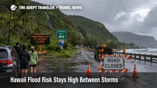
That changes the traveler math. A one off storm can be planned around. A destination that gets hit again before drainage, slopes, roads, and beaches fully recover becomes much harder to trust for fixed plans. The result is a longer tail of disruption, especially where a hotel stay, rental car trip, or airport run depends on roads and low lying corridors staying open. Hawaii's own emergency and transportation updates in recent days have included flash flooding alerts in Otake Camp, a Kamehameha Highway closure at Waimea tied to a rockslide and flooding, and a NOTAM for a flooded taxiway at Kawaihapai, also known as Dillingham Airfield.
Which Hawaii Trips Are Most Exposed
The exposure is uneven. Travelers staying in dense urban resort zones with flexible schedules and short airport transfers face a different risk profile from visitors doing scenic drives, North Shore day trips, waterfall stops, hiking plans, or interisland hops with little buffer. Repeated storms raise the odds that the failure point is on the ground, not in the air. Roads can close, slopes can give way, local flooding can cut off a route that looked usable earlier, and tour operators can cancel with little notice because access or safety conditions changed first.
Oahu's North Shore remains one of the clearest examples of how this spreads through travel. In an earlier Adept Traveler article, Oahu Flooding Hits North Shore Travel Plans, the core risk was already road dependence rather than a statewide airport shutdown. That logic still holds. Travelers moving between Honolulu and exposed coastal or valley areas are more vulnerable than those remaining in one place. Visitors with self drive itineraries on Maui and Hawaiʻi Island should think the same way, because saturated soils and repeated heavy rain make runoff, rockfall, and localized closures more likely even when a forecast no longer looks historic.
What Travelers Should Do Now
Travelers with Hawaii departures in the next 24 to 72 hours should judge the trip by ground dependence, not by the assumption that airports staying open means the itinerary is fine. Recheck county emergency alerts, HDOT road conditions, airline status, and lodging messages before leaving for the airport or committing to long drives. If your plan depends on a single exposed road, a same day airport transfer from a remote stay, or a tightly timed interisland connection, add more buffer now or shift the plan toward shorter, lower exposure movements.
Rebooking is smarter than waiting when the trip includes a fragile chain, for example hotel to rental car to coastal road to airport, or when key activities are outdoors and cannot be moved. Waiting can still make sense for travelers staying in major visitor zones with flexible plans and extra nights built in, especially if they are not crossing an island for a flight. The wrong move is pretending that better weather for a few hours means the whole network has reset.
Over the next day or two, watch for three signals. The first is whether the Flood Watch is reduced or extended. The second is whether Hawaii DOT shifts from isolated closure notices back toward normal operations. The third is whether local hotels, parks, beaches, and tour operators continue to warn about access limits after the heaviest rain passes. In an earlier Adept Traveler article, Hawaii Flood Recovery Leaves Beach, Park Gaps, the state had already moved into an uneven cleanup phase. The newer April weather round means travelers should assume that unevenness can deepen again.
Why Repeated Hawaii Storms Create a Longer Travel Problem
The mechanism is straightforward. Kona lows are not unusual in Hawaii, but the recent sequence was unusually intense and closely spaced. University of Hawaiʻi researchers and National Weather Service material show how heavy rain stacked up across multiple islands, while state and county recovery work was still underway. When that happens, the system becomes more fragile because soils are already wet, streams rise faster, debris remains in play, and infrastructure has less time to recover before the next event.
There is also a coastal dimension. Researchers cited by SFGate said compound flooding, where heavy rain overlaps with tides, surge, groundwater, and sea level effects, can worsen impacts in low lying coastal areas. That matters for travelers because Hawaii trips often rely on shoreline roads, beach access points, harbor areas, canal systems, and resort districts that may look operational until water movement, drainage limits, or surf conditions change. The practical result is that Hawaii flood travel risk now behaves less like a short disruption headline and more like an itinerary resilience problem. Until watches ease and access updates stabilize, travelers should treat recovery itself as part of the weather story.
Sources
- Office of the Governor - Governor Green Announces Presidential Disaster Declaration Approval For Hawaiʻi
- Hawaiʻi Mesonet Captures 135 mph Winds, Extreme Rainfall During Storm
- NWS Honolulu Forecast Office
- Area Forecast Discussion for Hawaii
- Weather Related Traffic Alerts, Hawaiʻi Department of Transportation
- Kamehameha Highway at Waimea Bay to Remain Closed Through Saturday, April 11
- Governor Green Issues Emergency Proclamation Ahead of Severe Storm System
- March 2026 Kona Low Storms, Hawaiʻi Emergency Management Agency
- Hawaii Hasn't Seen Storms This Bad in 1,000 Years. What's Behind It?