Flight delays and airport impacts: October 12, 2025
Wind, low ceilings, and a pocket of thunderstorms will shape Sunday operations across the National Airspace System. The FAA's daily plan shows active Ground Delay Programs at Boston Logan International Airport (BOS), Newark Liberty International Airport (EWR), and Ronald Reagan Washington National Airport (DCA), with additional metering or brief ground stops possible at Washington Dulles International Airport (IAD), LaGuardia Airport (LGA), and John F. Kennedy International Airport (JFK). Phoenix Sky Harbor International Airport (PHX) may see weather-related initiatives as storms pop over central and southern Arizona.
Key points
- Why it matters: Multiple GDPs and Northeast winds will slow connections and arrivals.
- Travel impact: Expect longer taxi and airborne holding around New York and Washington hubs.
- What's next: ATCSCC updates after 10:15 a.m. CDT can add or relax programs.
- Phoenix storms could trigger pauses or reroutes into the afternoon.
- Oceanic route L454 is closed until 11:00 a.m. EDT, prompting diversions.
Snapshot
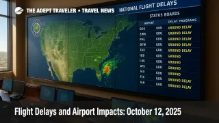
As of the 844 a.m. CDT operations plan, BOS, EWR, and DCA are under active Ground Delay Programs, each driven by wind, low ceilings, or visibility. The plan flags possible ground stops at IAD after 1000 a.m. CDT and again after 200 p.m. CDT, LGA likely metering after 1100 a.m. CDT, and JFK possible initiatives after noon CDT. En route, thunderstorms are expected across several centers, with a specific marginal severe risk focused on Arizona that could nudge PHX into tactical holds or departure spacing. Atlantic route L454 is closed through late morning on the East Coast, which can lengthen transatlantic flows and reroutes.
Background
The FAA's Air Traffic Control System Command Center publishes a rolling "Operations Plan" to outline expected constraints, staffing triggers, and planned traffic management initiatives each day. Typical tools include Ground Delay Programs to meter arrivals when weather or configuration lowers an airport's acceptance rate, and short ground stops to reset spacing during volatility. This week's broader context has included periodic controller staffing constraints, which can compound even routine weather. Travelers connecting through the Northeast should build buffer time, especially where winds and low ceilings historically drive configuration changes and runway swaps.
Latest developments
Northeast wind and ceiling constraints at Boston and the New York terminals
BOS is running a GDP this morning for wind and low ceilings, with similar conditions reducing acceptance rates at EWR and tactical constraints expected at LGA and JFK around midday on the East Coast. Expect EDCT metering on arrivals within the published distance rings and potential compression revisions if ceilings lift. Oceanic flow is also impacted by the temporary closure of Atlantic route L454, which can ripple into New York Oceanic sectors and JFK long-hauls. Watch for SWAP and CDR usage in the afternoon if cells build south of New England.
Washington area, staggered holds possible at Reagan National and Dulles
DCA remains under a GDP for wind and low ceilings, while IAD may see intermittent ground stops late morning and again mid-afternoon Eastern Time. Potomac Consolidated TRACON is operating tactically, so short-notice revisions are possible as clouds and flow constraints evolve over the Chesapeake to Appalachians corridor. If you are connecting between DCA and IAD or transiting via LGA or EWR, allow extra time for gate swaps and EDCT pushes.
Storm risk concentrates over Arizona, putting Phoenix in the spotlight
The Day 1 Convective Outlook places a marginal severe risk over parts of southern and central Arizona, with gusty winds and small hail possible. PHX has thunder listed as a terminal constraint, and the plan notes a low-confidence increase in arrival rate before mid-morning MST. Expect stop-and-go departure flows, tactical arrival routes, and possible CDR usage through the afternoon if outflows cross final.
Analysis
Today's pattern is a classic shoulder-season blend, where widespread IFR ceilings and brisk surface winds in the Northeast intersect with localized convection in the Southwest. The most material network impacts will center on the New York, Boston, and Washington complexes because metering there quickly propagates across dozens of spoke airports. With BOS, EWR, and DCA already in GDPs, the threshold question is whether ceilings lift enough by early afternoon to permit higher arrival rates, or whether additional initiatives at LGA and JFK tighten the screws into the evening push. Phoenix is the wild card. Even a brief convective window can force runway configuration changes that ripple into holding and release times. Oceanic route constraints, notably the L454 closure until late morning Eastern, introduce minor transatlantic friction but should ease by midday. Construction-related runway and taxiway closures at several hubs remain background noise rather than primary drivers.
Final thoughts
Plan extra connection time if you are transiting the New York, Boston, or Washington hubs, and monitor airline notifications for EDCT changes. For PHX, early departures have the best odds before storms organize. If your itinerary touches both the Northeast and transatlantic flows, expect small reroutes until the oceanic constraint clears. Check status frequently, and if you must rebook, target mid-afternoon arrivals where possible to miss the deepest metering. We will keep tracking airport impacts throughout the day to help you navigate flight delays and airport impacts.