Flight delays and airport impacts: October 13, 2025
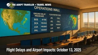
A coastal storm is tightening its grip on the Northeast, bringing periods of heavy rain, low ceilings, and strong winds that are pushing airlines and airports into delay-management mode. The FAA's daily operations plan points to likely ground delay programs at Boston Logan International Airport (BOS) and LaGuardia Airport (LGA), with possible actions at John F. Kennedy International Airport (JFK), Newark Liberty International Airport (EWR), Philadelphia International Airport (PHL), and Ronald Reagan Washington National Airport (DCA). Later today, overlapping space launches could prompt offshore route closures near Florida.
Key points
- Why it matters: A nor'easter is set to trigger delay programs at major Northeast hubs.
- Travel impact: Expect elongated taxi-out and holding times, missed connections, and rolling gate changes.
- What's next: Window for GDPs peaks this afternoon and evening, tapering as winds ease.
- BOS and LGA most likely to see programs, with JFK, EWR, PHL, DCA possible.
- Rocket launch windows may shift Florida oceanic routes this evening.
- Western hubs watch showers and isolated storms near San Francisco.
Snapshot
The FAA's current plan highlights low ceilings, wind, and embedded thunderstorms across New England and the New York metro. Boston Logan, LaGuardia, and possibly Newark and JFK could move into formal ground delay programs to meter arrivals during reduced acceptance rates. Philadelphia and Washington National may see shorter programs or brief metering as bands rotate inland. As the coastal low lifts north late day, airlines will work recovery banks into the evening schedules. Separately, SpaceX launch windows tonight could close portions of offshore airspace near Florida, shifting select flows to and from Orlando and South Florida. Nationwide delays remain elevated, though not uniform, with ripple effects most pronounced on flights touching the Northeast corridor.
Background
An early-season nor'easter is driving gusty onshore winds, coastal flooding, and IFR ceilings from the Mid-Atlantic into New England. The National Weather Service has highlighted 30 to 50 mph gusts near the coast, with marine hazards and coastal flood advisories in multiple states. Over the weekend, the FAA intermittently deployed ground programs across the New York and Philadelphia metros as the storm organized offshore. On the West Coast, Los Angeles International experienced a brief FAA ground stop on October 12 due to an equipment outage, underscoring the system's sensitivity during a broader period of constrained staffing and weather-driven complexity. Today's operational priorities concentrate on BOS and LGA first, then the broader N90 airspace, with Florida oceanic routes on launch watch this evening.
Government shutdown flight delays and TSA wait times
Latest developments
Nor'easter drives likely GDPs at BOS and LGA
The FAA's operations plan calls out Boston Logan and LaGuardia as most likely for ground delay programs, citing wind, rain, and low ceilings that cut arrival rates. JFK and Newark could join during peak convective and wind periods, while Philadelphia and Washington National sit on the edge for shorter actions tied to bands pivoting inland. For travelers, this means departures to these airports may be held at origin, average delays could build through the afternoon push, and connection buffers under one hour will be vulnerable. If winds back and ceilings lift after sunset, programs should compress and cancelation risk declines, though crews and aircraft may remain out of position into the late banks.
D.C., Philly, and corridor knock-ons
In the D.C.-Philly corridor, brief metering or low-visibility operations remain possible as showers stream north. Washington National's river visual procedures are sensitive to ceilings and visibility, so expect pockets of extended spacing even without a formal GDP. Philadelphia may toggle between arrival spacing and short GDP periods if ceilings fluctuate near minima. Secondary effects include gate holds for deicing-like congestion management during heavier bursts of rain, slow turns on narrowbody banks, and rolling flow restrictions for departures feeding New York terminal routes. Travelers on shuttle-style services should monitor carrier apps for gate and time changes every 15 to 30 minutes.
Western weather, runway work, and Florida launch windows
San Francisco International Airport (SFO) faces showers and isolated thunderstorms this afternoon, which can reduce acceptance on closely spaced parallels. Denver International Airport (DEN) has runway and taxiway work that may trim throughput during peaks, and Phoenix Sky Harbor International Airport (PHX) continues phased construction that occasionally nudges departure spacing. In Florida, overlapping SpaceX launch windows tonight could close portions of offshore airspace, prompting reroutes that add a few minutes en route for flows into and out of Central and South Florida. Select runway projects, including at Fort Lauderdale-Hollywood International Airport (FLL) and Tampa International Airport (TPA), remain in effect and can constrain operations during busy pushes.
Flight delays and airport impacts: October 12, 2025
Analysis
Today's playbook is classic autumn coastal-storm management. When winds quarter across finals and ceilings sit near ILS minima, New York and Boston shift from volume-driven congestion to weather-limited acceptance, and that drives ground delay programs. Expect airlines to prioritize long-haul arrivals and high-connect banks, pushing discretionary flying later, which creates uneven delays by route. If BOS and LGA enter GDPs first, JFK and EWR often inherit metering as New York TRACON spreads demand across fields. The biggest traveler risk window is mid-afternoon through the dinner push, when inbound banks stack, turns slow, and missed connections cascade. Out west, even modest showers at SFO can pinch throughput because of runway geometry, so keep an eye on transcon returns. Finally, rocket range closures rarely strand flights, but they can add minutes to Florida flows and reduce flexibility during recovery. Build extra buffer time, watch rebooking windows, and favor nonstop options where possible.
Final thoughts
Plan for cushion if your itinerary touches the Northeast, especially Boston or New York. Check in early, monitor your airline app for rolling gate changes, and keep carry-on only if you can. If your destination is flexible, targeting later-evening arrivals after the worst winds ease can help. Florida-bound travelers should account for minor reroutes around launch windows. With proactive airline recovery and improving weather tonight, the system should unwind, but expect lingering flight delays.