Northern Ontario Winter Storm To Hit Highway 11/17
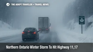
A Northern Ontario winter storm Highway 11 watch is now in effect for the corridor between Fort Frances and Thunder Bay, as Environment and Climate Change Canada warns that a Colorado low could drop 20 to 30 centimetres of snow between November 25 and 27. Drivers on Highway 11, Highway 17, and the Trans Canada Highway between Fort Frances, Thunder Bay, Dryden, Geraldton, and Marathon face a strong chance of whiteout conditions, drifting snow, and multi day disruption as the system moves through. Travelers who have the flexibility to shift long distance drives should move departures earlier in the week or delay them until plows have had time to fully clear the main corridors, while anyone who must be on the road should plan conservative speeds, long buffers, and full winter emergency kits.
The core change for travelers is that a general outlook for messy weather has hardened into formal winter storm watches for multiple northern Ontario forecast zones, including Atikokan, Lake Nipigon, Greenstone, Nipigon, and Superior North, which greatly increases the odds of highway closures and hazardous driving on Highway 11 and Trans Canada Highway 17.
Where The Storm Hits Hardest
Environment and Climate Change Canada extended forecasts call for periods of snow beginning Tuesday night, November 25, then continuing through Wednesday and tapering Thursday for zones that cover Fort Frances to Thunder Bay, Dryden and Vermilion Bay, Greenstone and Geraldton, and Nipigon through Marathon. In the Geraldton, Manitouwadge, and Hornepayne region, the agency highlights a sequence of snow, local blowing snow, and windy conditions from Tuesday night into Wednesday night, with lingering flurries and cold through Thursday. Similar wording appears for Nipigon, Marathon, and Superior North, where snow and blowing snow are expected as the low deepens over Lake Superior.
The Weather Network forecasts a swath of heavy snow along the Minnesota border in northwestern Ontario, specifically between Fort Frances and Thunder Bay, and flags that this band will directly affect travel along Highway 11 and the Trans Canada Highway between Thunder Bay and Dryden. Local coverage from NetNewsLedger echoes the federal alerts, noting winter storm watches for Thunder Bay and Greenstone with language that stresses sharply reduced visibility, 15 to 30 or more centimetres of accumulation, and dangerous blowing snow.
Timing And Travel Windows
The most challenging period for drivers is likely from late Tuesday evening, November 25, through the day on Wednesday, November 26, when snow rates and winds are both expected to peak, and when plow crews may struggle to keep up on exposed stretches of Highway 11 and Highway 17. By Thursday, November 27, forecasts suggest lighter snow and flurries, but blowing snow may still cut visibility and push drifts back across lanes, especially in the open country between Dryden and Thunder Bay and across the Lake Superior north shore between Nipigon and Marathon.
If you can complete a cross province run between Thunder Bay and points east or west by midday Tuesday, you have a better chance of beating the worst of the storm. If that is not possible, the safer alternative is to postpone non essential trips until late Thursday or Friday when the snow has ended and road crews have had time to widen lanes and clear shoulders. Overnight travel in the heart of the storm window will be particularly risky, since temperature drops will limit the effectiveness of salt, visibility can collapse with little warning, and help may be hours away on remote segments with poor mobile coverage.
Highway 11, Highway 17, And Trans Canada Risk Zones
The Highway 11 corridor from Fort Frances through Atikokan and into Thunder Bay is one of the main links between the Prairies and southern Ontario. It passes long stretches of forest and shield country where there are few services, sparse lighting, and limited alternate routes, which means any collision or jackknifed truck can shut the highway for hours. In this storm setup, that entire corridor sits close to the deformation zone of the Colorado low and within the heaviest forecast snow band, which raises a real risk of prolonged closures or slow moving convoys behind plows.
Farther east, the Trans Canada Highway 17 stretch from Thunder Bay to Dryden, and from Nipigon past Marathon toward Wawa, is also exposed. This shoreline and highland route frequently picks up extra lake enhanced snow and strong crosswinds off Lake Superior, a combination that can produce sudden whiteouts on curves and hilltops even when conditions a few kilometres away look manageable. Veteran drivers often treat these segments as all day projects in winter, and current forecasts support that conservative approach for the middle of the week.
Coach services and long distance buses, such as those operated by Ontario Northland, may face cascading delays and cancellations when highways close for weather or collisions, and small communities along the route could see late or missed deliveries as trucks wait out the worst of the storm in rest areas or service centres. Roadside motels in Thunder Bay, Dryden, and Nipigon often fill quickly during major storms, so travelers should not count on last minute room availability if they try to ride conditions until they deteriorate.
How This Affects Flights And Local Transfers
Thunder Bay International Airport (YQT) serves as a key regional hub between northern Ontario communities and larger cities such as Toronto, Winnipeg, and Ottawa. Although the airport itself is not under a separate aviation warning at the time of writing, the combination of heavy snow, low ceilings, and gusty winds raises the odds of delays, diversions, and longer de icing queues on November 26 in particular.
Even if flights operate close to schedule, ground access can break down first. Highway connections into Thunder Bay, local roads feeding the airport, and hotel shuttle routes may all be slowed or blocked, which means early morning departures and late night arrivals are most exposed. Travelers connecting between road and air should build at least several extra hours into their plans, treat separate tickets with caution, and review recent guidance on weather related delays into Toronto and Montreal, such as Adept Traveler s earlier Canada wide weather ripple outlook and its Toronto winter transfer advisory.
How Drivers Should Prepare
For anyone who must drive Highway 11 or Trans Canada Highway 17 during this storm window, preparation is not optional. Ontario 511 provides live maps, road condition text reports, highway cameras, and incident feeds that should be checked before departure and at each major stop. Ontario Provincial Police recommend calling 911 only for emergencies and using their regional social channels or non emergency line to track broader safety messaging and detours.
Vehicles should be equipped with proper winter tires, topped up with fuel, and loaded with a cold weather kit that includes extra warm clothing, blankets or sleeping bags, non perishable food, water, a shovel, traction aids, a booster pack or cables, and a phone charger that does not rely solely on the car battery. Drivers should share their route and expected arrival time with someone off the road, keep speeds well below posted limits when visibility drops, and avoid passing plows unless absolutely necessary. In a full whiteout or if conditions become unmanageable, the safest choice is often to exit the highway, wait in a safe location such as a service centre or motel, and resume only after visibility improves and plows have made another pass.
Travelers planning future trips to the region can also use this event as a reminder that Northern Ontario winter travel demands built in flexibility. Adept Traveler s Thunder Bay destination guide, while focused on attractions and planning tips, can help visitors understand how geography and lake effect weather shape local conditions, and future seasonal updates will continue to track how storms, squalls, and cold snaps affect both road and air travel across the province.
Sources
- Extended forecasts for Northern Ontario, Environment and Climate Change Canada
- Northern Ontario winter storm watch corridor, The Weather Network
- Thunder Bay winter storm watch coverage, NetNewsLedger
- Greenstone and Geraldton winter storm watch coverage, NetNewsLedger
- Ontario 511 road conditions and traveler information
- Ontario Provincial Police, official site
- Canada weather ripple and delays outlook, Adept Traveler
- Toronto winter travel advisory and transfer guidance, Adept Traveler
- Thunder Bay destination guide, Adept Traveler