Flight Delays And Airport Impacts: December 2, 2025
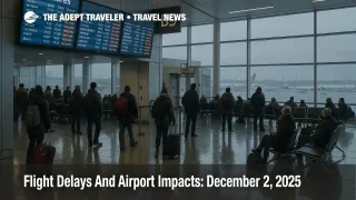
A new round of winter weather is driving US flight delays December 2 2025, as the Federal Aviation Administration warns of rain, snow, low clouds and poor visibility at Boston Logan International Airport (BOS), New York's big three airports, Philadelphia International Airport (PHL) and the Washington, DC terminals. Travelers connecting through these hubs, or routing to Florida and the West Coast through them, are facing elevated risks of ground stops, holding and missed connections, on top of the backlog from the post Thanksgiving rush. With traffic management programs already lining up for the afternoon, anyone on a tight same day itinerary should be thinking about extra buffer or alternative routings.
The core pattern is that US flight delays December 2 2025 are being driven less by structural flight caps and more by a broad early season winter storm, which is pushing low ceilings and snow across the Northeast, thunderstorms along Florida corridors, and low clouds into hubs such as Seattle Tacoma International Airport (SEA) and San Francisco International Airport (SFO).
Where Today's Flight Delays Are Concentrated
In its Tuesday Daily Air Traffic Report, the FAA highlights weather driven delay risks at Boston, New York's John F. Kennedy International Airport (JFK), LaGuardia Airport (LGA) and Newark Liberty International Airport (EWR), plus Philadelphia, Baltimore Washington International Thurgood Marshall Airport (BWI), Washington Dulles International Airport (IAD) and Ronald Reagan Washington National Airport (DCA). Low clouds are also flagged at Hartsfield Jackson Atlanta International Airport (ATL), Charlotte Douglas International Airport (CLT), SEA and SFO, with thunderstorms at Orlando International Airport (MCO).
The latest Operations Plan Advisory from the Air Traffic Control System Command Center goes further, spelling out a series of potential afternoon ground stops and Ground Delay Programs at EWR, LaGuardia, JFK, DCA, PHL, SFO and MCO, along with New York reliever airports such as Teterboro Airport (TEB). The plan also calls out a flow constrained area for traffic from the Northeast into Florida, a sign that routes from New York, Philadelphia and Washington toward Jacksonville and Miami centers will be throttled as thunderstorms flare in the Jacksonville and Miami airspace sectors.
For travelers, this translates into a clear pattern. Morning flights that have already pushed out of the most affected airports will have a better chance of operating close to schedule, while mid afternoon and evening departures that rely on aircraft cycling in and out of these hubs are far more exposed to compounding delays. If your connection depends on a late afternoon arrival into New York, Boston or Washington with less than two hours to spare, it is worth treating that plan as tentative.
A Third Winter Storm And A Very Wide Footprint
Today's challenges are not happening in isolation. Over the weekend, a strong winter storm hit the Midwest and Great Lakes, canceling more than 2,000 flights and delaying thousands more, especially through Chicago hubs. As that system moved east, another major storm began to organize along the East Coast, and forecasters now estimate that more than 55 million people across roughly 40 states are under some form of snow or ice alert from Kentucky to Maine.
State authorities in New Jersey have already declared a state of emergency in several northern counties because of heavy, wet snow and icing, which will slow road access to Newark and New York area airports just as ground stops become more likely. Similar conditions in parts of Pennsylvania, Connecticut and Massachusetts are enough to trigger school closures and local travel advisories, which tend to spill into airport staffing, deicing queues and ground handling.
The weather footprint also stretches beyond the Northeast. Low ceilings at ATL and CLT tighten the margin for Southern connections, especially on routes feeding Florida and Caribbean departures, while low clouds and visibility at SEA and SFO increase the odds of flow management programs and longer arrival spacing on the West Coast. Thunderstorms near MCO are a particular concern, because Florida remains one of the busiest holiday markets and any ground stop there ripples quickly through the national network.
Traffic Management Programs And Runway Work
The ATCSCC advisory sketches out the toolkit planners are ready to use if conditions deteriorate, including possible ground stops, Ground Delay Programs and reroutes using CDRs and SWAP routes in the New York and Potomac control areas. These measures temporarily slow arrivals into congested hubs or reroute traffic around weather, which protects safety but lengthens gate to gate times and increases the chance that inbound aircraft miss their next departure slots.
Several runway and taxiway projects also remain in play. The advisory notes ongoing taxiway pavement repairs at SFO, runway closures at Chicago Midway International Airport (MDW) and Nashville International Airport (BNA), and a runway closure at Palm Beach International Airport (PBI), along with long running construction at San Diego International Airport (SAN). On a clear day, these constraints might only add a few minutes of taxi or holding, but layered on top of winter weather, they can turn into another source of delay, particularly for evening departures when crews and aircraft are approaching their daily duty limits.
There is also a planned SpaceX Starlink launch from the Cape Canaveral area this evening, which can temporarily close offshore routes and add complexity for Florida bound and Caribbean traffic using Atlantic corridors. While these launch windows are narrow and well choreographed, they are still one more reason why flights into and out of Florida tonight may see reroutes or longer track miles.
How Bad Is It Compared With The Weekend
By midday Tuesday, one analysis using FlightAware data reported about 7,575 total flight delays and 408 cancellations across the United States, with Chicago, New York City, Boston, Des Moines, Fort Lauderdale and Detroit among the hardest hit airports. That sits on top of the Sunday peak, when more than 12,000 delays and over 1,400 cancellations were logged as travelers tried to return from Thanksgiving trips through the same set of hubs.
The good news, to the extent there is any, is that the FAA's emergency order that temporarily forced percentage flight cuts at high volume airports during the government shutdown has been lifted since November 17, which means today's disruptions are driven primarily by weather rather than formal capacity caps. The bad news is that controller staffing remains tight, and the system is still working through a backlog of displaced passengers, so each new wave of winter storms lands on an already stressed network instead of a clean slate.
If you are still trying to get home from the holiday period, this means that it may take an extra day or two for schedules to fully normalize, even if the weather improves by Wednesday. Travelers who can push nonessential trips into later in the week or the weekend will have a smoother experience than those who insist on flying during peak recovery windows.
Practical Steps For Travelers Today
For anyone booked through Boston Logan, New York's airports, Philadelphia, Washington, Orlando or San Francisco today, the safest assumption is that your itinerary is vulnerable to rolling delays. Check your flight status directly with the airline before you leave for the airport, sign up for text or app alerts, and keep an eye on whether your inbound aircraft is operating on time from its previous leg.
On domestic connections, aim for at least three hours of buffer through the Northeast, Florida and San Francisco, particularly for flights scheduled to arrive between early afternoon and mid evening when most of the traffic management initiatives are likely to be active. For international trips that connect through these hubs, four hours is a safer floor, and separate tickets are a poor idea in this environment because airlines are less willing to protect you when one of the legs is on a different booking.
If your plans are flexible, look at shifting to earlier departures, even if that means a predawn ride to the airport, or routing through less affected hubs away from the storm track. Secondary options such as Raleigh Durham, Cleveland or Houston may offer more reliable connections today than the usual Chicago, New York or Boston choices. For travelers headed to or from Florida, it can also be worth connecting through ATL or CLT early in the day instead of gambling on later flights that depend on a smooth flow from the Northeast.
On the ground, factor in extra time for roads and rails around northern New Jersey, New York City, Philadelphia and Boston, where snow, slush and local emergencies are already slowing traffic and commuter rail services. Rideshare and taxi availability may also be tighter than usual during heavier snow bands, so booking transfers earlier in the day, or using airport parking where practical, reduces the risk of missing a departure because of a last mile bottleneck.
For a deeper explanation of how winter storms interact with airline schedules and what rebooking options typically look like, see our guide to winter storm flight delays in the United States, along with yesterday's briefing on December 1 flight delays, which sets the stage for today's patterns across the same set of hubs.
Sources
- FAA Daily Air Traffic Report, December 2, 2025
- ATCSCC Advisory 025 DCC, Operations Plan, December 2, 2025
- Busy Thanksgiving Weekend Flight Delays Spill Over To Tuesday
- Thousands of U.S. Flight Delays, Hundreds of Cancellations, After Thanksgiving
- More Than 55 Million Americans On Alert For Snow And Ice From Kentucky To Maine
- State Of Emergency Declared Across Hunterdon, Morris, Passaic, Sussex, And Warren Counties
- DOT & FAA Announce Termination Of FAA Emergency Order, Return To Normal Operations