US Winter Storm And Nor'easter Hit Flights, Roads
A powerful early season storm has turned US winter storm flights into a rolling disruption, starting with a Great Lakes and Midwest blizzard and now feeding a nor'easter that is targeting the interior Northeast. Des Moines International Airport (DSM) closed for roughly half a day after a Delta Connection regional jet slid off an icy runway, while Chicago, Detroit, and other hubs logged hundreds of cancellations and thousands of delays over the Thanksgiving return rush. As the storm energy reaches the East Coast between December 2 and 3, 2025, it will shift the worst conditions to key air and road corridors from Pennsylvania into New England, making both flights and long drives conditional.
The combined Midwest blizzard and Northeast nor'easter will reshape plans for travelers who are flying through central US hubs or using I 80, I 81, I 84, I 87, and parts of I 95, forcing many to accept longer connections, reroutes, or slower drives until snow bands, ice, and deicing backlogs clear.
What Changed, From Midwest Blizzard To Northeast Nor'easter
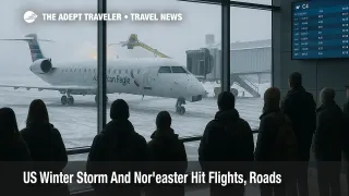
The first phase of the system hit the upper Midwest and Great Lakes on Saturday and Sunday, November 29 and 30, dumping more than a foot of snow in parts of Iowa, Wisconsin, and Michigan and setting a calendar day November snowfall record of 8.4 inches at Chicago O'Hare International Airport (ORD). More than 250 flights into and out of O'Hare were canceled by early afternoon Sunday, with about 1,600 delayed, and national counts reached more than 12,000 delays and hundreds of cancellations, according to FlightAware summaries.
As the low pressure system tracks toward the Atlantic, it is now redeveloping into the first major nor'easter of the season for the Northeast. The National Weather Service expects 6 to 10 inches of snow in interior zones from northeastern Pennsylvania through the Catskills and into northern New England, with locally higher totals over higher elevations, while a mix of rain and freezing rain brushes the I 95 corridor from Philadelphia northward. This overlap between ongoing Midwest recovery and new Northeast impacts is what keeps schedules unstable through at least December 3, 2025.
Des Moines Closure And Knock On Effects
Des Moines International Airport (DSM) became a critical choke point on the evening of Saturday, November 29, when Endeavor Air Flight 5087, a Delta Connection Bombardier CRJ 900 arriving from Detroit, skidded off the runway around 1000 p.m. local time during landing in heavy snow. Airport officials reported that about 10 inches of snow had already fallen in the Des Moines area, with up to 15 inches in nearby parts of Iowa, and the runway conditions were slick enough that the aircraft left the paved surface while turning.
No injuries were reported and passengers were deplaned by stairs and bused to the terminal, but the incident forced DSM to halt operations for roughly 12 to 14 hours while the aircraft remained in place pending federal review. Local reporting counted about 52 delayed or canceled flights during the closure, with at least three inbound flights diverted, and one Delta flight originally bound for Iowa was sent to Kansas City International Airport instead, turning a routine pickup into a three hour drive for relatives.
For travelers, that closure did not just impact Des Moines. It also removed one spoke from the Delta network while regional crews and aircraft were out of position, which can propagate misconnects and rolling delays across hubs in Detroit, Minneapolis, and other cities even after DSM reopened on Sunday. Anyone flying in the next few days on routes that touch DSM, or that depend on regional jet feeds from Iowa and neighboring states, should expect a higher chance of equipment swaps, last minute gate changes, and tighter rebooking options if something else goes wrong with the nor'easter.
Where Flight Impacts Are Likely To Be Worst
In aviation terms, the storm is hitting in two overlapping zones. The first is the central US, centered on Chicago O'Hare and Chicago Midway International Airport (MDW), along with Des Moines, Detroit Metro Airport, and Minneapolis Saint Paul International Airport, where heavy snow on November 29 and 30 already triggered large cancellation and delay totals.
The second zone is the interior Northeast, where winter storm warnings and advisories cover parts of Pennsylvania, New York, Vermont, New Hampshire, Maine, Massachusetts, and Connecticut. Major airports along or near these inland corridors, such as Albany International Airport (ALB), Manchester Boston Regional Airport (MHT), and Portland International Jetport (PWM), are positioned closer to the heavy snow bands and are more likely to see runway plowing, deicing queues, and low visibility approaches that slow operations or trigger ground delay programs.
Along the I 95 spine, including Philadelphia International Airport (PHL), Newark Liberty International Airport (EWR), John F. Kennedy International Airport (JFK), LaGuardia Airport (LGA), and Boston Logan International Airport (BOS), the current guidance leans toward mainly cold rain with some freezing rain risk inland. That reduces the chance of heavy snow accumulation in the big coastal cities but does not eliminate delays, because rain, low cloud ceilings, and icing aloft still slow arrival rates and lengthen taxi times.
The FAA Daily Air Traffic Report is already flagging winter weather, deicing, and low ceilings as key constraints for December 2, and it will provide the most up to date view of ground delay programs or ground stops as the nor'easter peaks.
Road Corridors, Interstates 80 And 95, And Secondary Highways
For drivers, the risk map looks slightly different. The heaviest snow and worst visibility are expected along interior corridors, including I 80 across Pennsylvania, I 81 down the Susquehanna Valley, I 84 across New York and Connecticut, and I 87 up the Hudson Valley, where up to 6 to 10 inches of snow and strong winds can quickly turn slush into rutted, icy lanes.
State agencies are already preparing. Pennsylvania is pretreating the Turnpike and has mobilized hundreds of plow operators and support staff, and Connecticut's Department of Transportation has more than 900 drivers and 640 plows on standby for the season's first significant winter storm, while warning that staffing gaps mean operations may feel stretched. In upstate New York, early bands of snow have already produced crashes on the Thruway and the Northway near Albany and Saratoga County, underlining how quickly conditions can deteriorate when the nor'easter intensifies.
By contrast, long stretches of I 95, particularly from Philadelphia through New York City into coastal southern New England, are more likely to see cold rain, ponding, and some localized ice where surface temperatures lag behind air temperatures. Those conditions still justify slower speeds and longer travel times, especially in heavy traffic, but they do not carry the same immobilizing risk as the interior snow belt.
How Winter Storms Translate Into Flight Delays
Winter storms affect aviation in several layers. Heavy snow reduces runway friction and visibility, which forces airports to close runways for plowing and deicing, cutting the number of arrivals and departures that can be handled per hour. Ice accretion risk on aircraft surfaces requires deicing at the gate or on centralized pads, which adds minutes to each departure and creates queues that can back up across a bank of flights.
On top of that, airlines must juggle aircraft and crews that are out of position when hubs such as Chicago, Des Moines, or Detroit take a hit. Even after the weather clears, recovery takes time, because planes and pilots have to be rotated back into their planned schedules, a process that can be slowed by crew duty time limits. If the FAA or local air traffic control centers impose ground delay programs or ground stops to manage inbound volumes, as described in FAA rules for such traffic management initiatives, that introduces further cascading delays.
Practical Strategies For Flyers Over The Next 48 Hours
For travelers with flights on December 2 and 3 anywhere in the US, the safest assumption is that the systemwide network will stay a little fragile until both the Midwest and Northeast work through backlogs. That means building in more buffer and being picky about routing.
If you are still booking or can change plans without penalty, favor nonstops that either stay entirely outside the storm zone or operate into the region after the worst of the snow has passed, especially on December 4. If a connection is unavoidable, routing through southern hubs such as Hartsfield Jackson Atlanta International Airport (ATL), Dallas Fort Worth International Airport (DFW), or Charlotte Douglas International Airport (CLT) may be more reliable than connecting through Chicago, Detroit, or New York while the storm is active.
When you cannot avoid affected hubs, treat minimum connection times as meaningless for this event. Aim for at least three hours between flights on a single through ticket and avoid booking separate tickets that would require you to reclaim baggage or recheck with a different airline. That guidance applies especially to flows that tie Midwest hubs to interior Northeast airports like Albany, Burlington, or Portland, which sit near the bullseye of the heaviest snow.
Proactively checking airline apps and enrolling in flight status alerts is essential, as Des Moines travelers discovered when the airport closure and diversions left some passengers relying on social media to understand what had happened to their flights. If your airline offers a weather waiver for this storm, use it early to move off tight same day connections or vulnerable routes before phone lines and chat queues fill up.
Driving And Multimodal Travel Advice
For drivers, the storm window from late night December 1 into December 3 is the period to treat with the most caution. In the interior zones where snow totals are highest, leaving several hours earlier or shifting long drives into daylight on the back side of the storm can dramatically reduce risk, especially on hilly segments of I 80, I 81, I 84, and I 87.
Build in extra time for airport transfers and intercity rail or bus connections, particularly in cities like Albany, Hartford, and Boston, where road conditions can slow arrivals well before rail or air services are officially delayed. Keep a winter kit in your vehicle, including warm clothing, a charged phone, water, snacks, and any medications you may need if you are stuck in a long backup.
For trips that combine flight and long drives, such as flying into Boston Logan then driving to northern New Hampshire or Maine, consider routing to an airport closer to your final destination after the storm clears instead, or build in an overnight near the airport before tackling mountain passes.
By treating the next 48 hours as a period of conditional plans and generous buffers, travelers can reduce the chance that this early season winter storm and nor'easter turn a routine December trip into an avoidable emergency.
Sources
- Des Moines airport closes after Delta plane slides off runway
- A Delta flight originally bound for Iowa instead landed in Kansas City early Saturday
- Des Moines International Airport
- Hundreds of flights canceled in Chicago after winter storm
- Early winter storm puts 16 million Americans under weather advisories
- Northeast prepares for first major snowstorm of season
- US north east braces for 'significant' snowfall after storm hits Midwest
- First winter storm for parts of interior Northeast brings snow
- Snow and Rain Storm December 2, 2025 briefing
- Connecticut prepares for first winter storm of season
- Live, Nor'easter arrives upstate, crashes reported on Thruway, Northway
- FAA Daily Air Traffic Report