Flight Delays And Airport Impacts: December 3, 2025
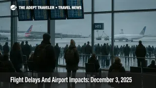
Travelers flying within or into the United States today are dealing with another round of winter related slowdowns, as the Federal Aviation Administration's Daily Air Traffic Report for Wednesday, December 3, highlights snow, low clouds, and gusty winds at a long list of major hubs. Boston Logan International Airport (BOS), Denver International Airport (DEN), Chicago O'Hare International Airport (ORD), and Chicago Midway International Airport (MDW) are all flagged for snow, while weather and wind issues stretch from Florida to the Pacific Northwest. Anyone connecting through these airports should expect gate holds, arrival spacing, and rolling delays, and build extra buffer into onward rail, rental car, and hotel plans.
In plain terms, the FAA's December 3 outlook says that snow and low clouds around Boston Logan and Denver, low clouds in Florida and Seattle, and snow in Chicago, combined with strong winds around New York City, San Francisco, and Las Vegas, are likely to slow flights at some of the country's busiest hubs. For most travelers this means slower than published schedules rather than a nationwide shutdown, but the pattern hits exactly the airports that feed transcontinental and transatlantic banks, so even modest delays can ripple outward through the day.
According to the FAA report, snow and low clouds are expected to affect flights in Boston and Denver, with additional snow in Chicago, while low clouds are forecast for Orlando International Airport (MCO), Fort Lauderdale Hollywood International Airport (FLL), Miami International Airport (MIA), Palm Beach International Airport (PBI), Detroit Metropolitan Wayne County Airport (DTW), and Seattle Tacoma International Airport (SEA). Strong winds are reported in the New York City system, meaning John F. Kennedy International Airport (JFK), LaGuardia Airport (LGA), and Newark Liberty International Airport (EWR), as well as San Francisco International Airport (SFO) and Harry Reid International Airport (LAS). That mix of snow, low ceilings, and crosswinds is exactly what forces controllers to increase spacing between arrivals and departures, which quickly translates into delays when banks are full.
Live tracking data underline that a meaningful share of the global schedule is already running behind. By early morning Eastern time, FlightAware was reporting about 9,559 delays worldwide and 382 cancellations, including 617 delays and 41 cancellations on flights within, into, or out of the United States. These numbers will move throughout the day, but they confirm that today is not a clean winter day where schedules run on autopilot. Instead, it is a day when smart travelers treat every connection through a snow or wind affected hub as provisional.
Today's pattern also comes on the heels of a brutal holiday stretch when winter storms and the season's first nor'easter already forced the cancellation or delay of more than 5,300 flights across the Midwest and Northeast, with Chicago and East Coast hubs taking heavy hits. Earlier in the week, Chicago set a November single day snowfall record at O'Hare that helped drive hundreds of cancellations and well over a thousand delays, while Detroit, Des Moines, and parts of the Great Lakes corridor also saw significant disruption. The result is that some aircraft and crews are still out of position, and today's fresh weather constraints land on top of a network that is already stretched.
For flyers in the Northeast, the main story is the combination of residual nor'easter impacts and local wind and ceiling issues. Boston Logan is wrestling with the tail end of snow and low clouds, which can force the use of specific instrument approaches and reduce runway acceptance rates. New York's JFK, LaGuardia, and Newark are all in the wind spotlight, which often leads to arrival metering and departure holds, especially during peak morning and evening banks. Travelers connecting through these airports to Europe or to domestic spokes should assume that short connections under about 90 minutes are unsafe today and ask airlines to move them to earlier feeder flights where seats exist.
In the Midwest, Chicago O'Hare and Chicago Midway are again dealing with snow, on top of the recent record setting event that already stressed local crews, snow operations, and de icing capacity. Denver is facing its own mix of snow and low cloud, which can compound delays when combined with winter operations on the ramp and at de icing pads. Passengers with itineraries that connect through Chicago or Denver into the Mountain West, West Coast, or international routes should be prepared for longer taxi times and airborne holding, and should avoid booking last departures of the day if there is any earlier option left.
Farther south, Orlando International, Miami, Fort Lauderdale, and Palm Beach are all flagged for low clouds. That may sound mild compared with snow, but low ceilings in busy Florida airspace can reduce arrival rates just as effectively, especially when combined with a lingering holiday traffic mix of leisure travelers and cruise connections. Travelers sailing out of South Florida ports or connecting from Caribbean and Latin American flights through these airports should leave more time between landing and cruise boarding or regional connections.
On the West Coast, Seattle Tacoma International Airport faces low clouds, while San Francisco is singled out for wind, a familiar combination in winter that can push long lines of inbound traffic into holding patterns when runway configurations are constrained. Harry Reid International Airport in Las Vegas is also under a wind flag, which can affect both arrivals and departures during busy convention and leisure periods. West Coast travelers should pay extra attention to flights that route through San Francisco or Seattle into Asia or Hawaii, since even relatively small delays on the first leg can create long missed connection gaps for long haul departures.
The broader good news is that, despite these weather constraints, the FAA's National Airspace System status does not currently show nationwide ground delay programs or widespread en route flow restrictions beyond the localized weather impacts. That means the system is functioning, with most delays driven by runway and approach capacity at specific airports rather than structural caps on traffic. For travelers, the operational takeaway is that the right combination of routing, departure time, and buffer can still produce a mostly on time day, even if the headline numbers look rough.
Practical steps matter more than ever on a day like this. Travelers should confirm that their contact details are current in airline apps, enable push notifications, and download boarding passes early so they are ready if a gate change or rebooking appears. Where possible, moving to an earlier flight into a weather affected hub, even one with a longer layover, is safer than clinging to a tight connection that depends on every segment being exactly on time. For same day meetings, cruise departures, or long haul connections, shifting critical travel to later in the week, once the nor'easter pattern has fully cleared and backlogs have burned off, will often be the lowest stress choice.
Internationally, today's messy U.S. picture intersects with unrelated disruptions elsewhere, including significant delays and cancellations at Indian hubs as IndiGo and other carriers work through technology issues and congestion at airports like Delhi and Mumbai. Travelers on multi leg itineraries that combine U.S. hubs with South Asian connections should treat their plans as highly conditional, and should consider overnight buffers in gateway cities instead of same day turns where feasible.
Sources
- FAA Daily Air Traffic Report, December 3 2025
- FlightAware live global delay and cancellation statistics
- Thanksgiving holiday winter storms and travel impacts
- First US nor'easter disrupts more than 5,300 flights
- Post Thanksgiving U.S. flight delays and cancellations
- IndiGo delays and cancellations amid tech and congestion issues