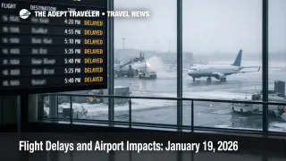
Flight Delays and Airport Impacts: January 19, 2026
U.S. air traffic managers are flagging a higher risk of flight delays today as wind in the New York metro area combines with snow, low ceilings, and winter operations across several major hubs. Travelers connecting through Boston Logan International Airport (BOS), Newark Liberty International Airport (EWR), Philadelphia International Airport (PHL), and Miami International Airport (MIA) are the most exposed if traffic management programs activate later in the day. The practical move is to protect connections now, prioritize earlier departures when you can, and use the FAA's timing cues to decide when to rebook versus wait.
The U.S. flight delays January 19 setup is a late day risk story, because the FAA plan points to possible ground stop or delay programs after the evening push begins, even while many airports show on time conditions early in the morning.
The FAA's current operations plan for January 19, 2026 calls out terminal constraints tied to wind in the New York metro area, plus snow and low ceilings in multiple regions. It also lists Newark for a possible ground stop or delay program after 700 p.m. Eastern Time, and the Miami area for possible programs after 800 p.m. Eastern Time, including Miami Opa Locka Executive Airport (OPF). Those are not guarantees, but they are the most actionable signals in the FAA plan because they tell you when the system expects demand and capacity to collide.
Early morning snapshots can look deceptively calm. FAA airport status pages showed Newark, Boston Logan, Philadelphia, Seattle Tacoma International Airport (SEA), Denver International Airport (DEN), Detroit Metropolitan Wayne County Airport (DTW), and Miami International operating on time around the early morning update window. The key is that winter day reliability often breaks later, when arrival rates tighten, gates fill, and one late bank pushes aircraft and crews into the next.
Who Is Affected
Travelers using New York area hubs are first in line for disruption risk today because wind in the New York metro airspace can force lower arrival acceptance rates, and that change propagates nationwide through metering. Even if your departure city is clear, your flight can be held at the gate when the constraint is downstream in New York terminal airspace, because the system prefers controlled ground holding over airborne holding.
Northeast travelers also face a layered risk profile. The FAA plan lists low ceilings, visibility limits, and snow affecting Boston, and it notes snow in the forecast mix for New York terminal operations. That matters most for passengers on short connections, and for anyone scheduled on the last nonstop of the day, because reaccommodation options thin out quickly once arrival rates dip.
Midwest and Mountain West travelers can still get pulled into the ripple. Snow is listed as a terminal constraint for Detroit, for the Chicago terminal area, and for Denver, and en route constraints include a Lake Erie routing limitation through the evening. When a major routing corridor is constrained, traffic managers often reflow aircraft onto fewer usable paths, which increases spacing, adds miles, and shifts arrival banks, even for flights that never touch the snow.
Florida flyers should watch the evening. The plan flags event volume in the Miami area and lists multiple active flow constraint areas into the Miami terminal complex through late evening. When demand spikes into a constrained arrival bank, the operational outcome is often gate holds at origin airports, longer taxi outs, and missed international connections, especially on itineraries that were built with minimal slack.
What Travelers Should Do
If you are traveling today, start by protecting the parts of your itinerary that are hardest to replace. Give yourself more connection time through New York area airports, Boston, Philadelphia, and Miami, and check your airline app for same day change offers, waiver language, or earlier flight options before airport lines build. If you are connecting on separate tickets, treat New York and Miami evening connections as fragile, because a modest delay can strand bags and break minimum connection times.
Use decision thresholds that match how late day programs behave. If your first flight is delayed enough that you would arrive with less than 45 minutes before boarding on your connection, move proactively rather than waiting at the gate, because metering tends to compress the schedule and reduce your rebooking choices as the day progresses. If you are booked on the last nonstop flight to your destination, or you have a time fixed event like a cruise check in or a meeting, your threshold should be even stricter, because there may not be viable later options.
Over the next 24 to 72 hours, monitor whether today's late day constraints knock aircraft and crews out of position for Tuesday morning banks. The signals to watch are whether Newark or the Miami area flips from "possible" to active programs tonight, and whether your inbound aircraft starts arriving late into your departure city. If you see repeated late arrivals on the same route, assume tomorrow morning's first wave has less recovery capacity, and plan extra buffer accordingly.
Background
The FAA's command center uses traffic management initiatives to keep flows safe when weather, staffing, runway limits, or en route constraints reduce how many aircraft can move through a terminal area per hour. A ground delay program meters departures bound for a constrained arrival airport by assigning controlled departure times, while a ground stop is a stronger measure that can temporarily pause departures to an airport when arrival capacity drops sharply.
The disruption propagation usually happens in layers. First order effects show up at the constrained hub as arrival rates are reduced, and the system starts holding departures at origin airports to prevent terminal airspace saturation. Second order effects then hit the network as aircraft arrive late to their next legs, gates fill, turns lengthen, and crew duty time margins shrink, which can convert a delay into a cancellation late in the day. A third layer appears when constrained routings shift arrivals into different banks, which strains baggage, customs waves, and onward connections, particularly in hub complexes like New York and Miami.
Today's FAA plan also includes operational friction that can matter when conditions tighten, including staffing trigger windows for Philadelphia area operations and the San Francisco International Airport (SFO) tower, plus multiple runway, taxiway, and ramp projects across the network. Those constraints do not automatically cause delays, but they reduce flexibility, and flexibility is what the system needs when weather and demand collide.
For continuity and scenario comparison, travelers can review yesterday's risk posture in Flight Delays and Airport Impacts: January 18, 2026 and the specific New York winter trigger case in LaGuardia Snow Delay Program Risk January 18, 2026.
Sources
- Current Operations Plan Advisory (ATCSCC ADVZY 027 DCC 01/19/2026)
- FAA Daily Air Traffic Report (last updated Friday, January 16, 2026)
- Newark Liberty International Airport Status (EWR)
- Boston Logan International Airport Status (BOS)
- Philadelphia International Airport Status (PHL)
- Miami International Airport Status (MIA)
- Detroit Metropolitan Wayne County Airport Status (DTW)
- Denver International Airport Status (DEN)
- Seattle Tacoma International Airport Status (SEA)