Winter Storm Fern US Flights, Hubs Strained Jan 25-26
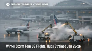
Winter Storm Fern is straining the U.S. air travel system as snow, sleet, freezing rain, and unusually widespread cold push airlines into mass cancellations and airports into reduced arrival and departure rates. Travelers are most affected at large connecting hubs where even moderate runway and visibility limits cascade into missed connections and aircraft swaps. The practical move for January 25, 2026, and January 26, 2026, is to assume severe irregular operations, rebook earlier than you normally would, and treat airport access as a separate risk when local power outages and icy roads are in the mix.
Winter Storm Fern US flights are now operating in a posture where cancellations are being used to protect the next day's network, which raises the odds that disruption lingers even after the heaviest precipitation shifts east.
FAA system planning on January 25, 2026, described compounded impacts from the Tennessee Valley through the Northeast, with snow and low visibility cited across multiple metro airspace complexes. In the same planning window, the FAA flagged constraints that can matter to travelers even when they sound technical, ground stops, controlled departure routes, and metering programs that hold flights at their origin airports to avoid airborne backups near the destination. The advisory also showed how disruption is not confined to one region, with separate constraint clusters tied to Texas, the Southeast, and the Northeast corridor that feeds long haul domestic and international banks.
Public reporting underscored the scale. Reuters reported nearly 10,000 cancellations scheduled for Sunday, January 25, 2026, plus more than 4,000 on Saturday, alongside rising power outages that complicate basic trip execution. The Associated Press reported more than 14,100 cancellations since Saturday, with major disruptions at hubs including Dallas Fort Worth, Charlotte, Philadelphia, Atlanta, and the New York City area, and it highlighted near total cancellations of departures at Ronald Reagan Washington National Airport (DCA).
Who Is Affected
Travelers connecting through the largest hubs are the first group exposed, even if their origin and destination look clear on a weather map. When arrival rates are capped at a hub, the system protects itself by delaying or canceling flights upstream, which is why a traveler leaving a clear sky airport can still see long holds, gate delays, or same day cancellations. This is especially true for routes that depend on banked connections through Hartsfield Jackson Atlanta International Airport (ATL), Dallas Fort Worth International Airport (DFW), Charlotte Douglas International Airport (CLT), Philadelphia International Airport (PHL), Chicago O'Hare International Airport (ORD), and the New York City area airports, John F. Kennedy International Airport (JFK), LaGuardia Airport (LGA), and Newark Liberty International Airport (EWR).
Anyone with a hard arrival deadline is the second group at risk. When cancellations spike into the high thousands, the limiting factor becomes seat inventory on surviving flights, not whether a single delayed flight eventually departs. That creates a predictable failure mode, you wait too long, the rebooking pool evaporates, and the remaining options become long misconnect chains or next day travel that requires an unplanned hotel night. If your trip includes a cruise embarkation, a prepaid tour start, a medical appointment, or a one time event, the threshold for proactive rebooking should be lower than normal.
A third group is travelers whose plans depend on ground systems behaving normally. Reuters and federal agencies pointed to major power outages and grid stress measures during the storm, and that matters for air travel because power loss can degrade traffic signals, transit headways, fueling and charging access, hotel operations, and even basic communications. Add ice on roads and bridges, and airport access becomes unreliable even when a flight technically remains scheduled.
What Travelers Should Do
Start by making a binary call on whether your trip must happen on January 25, 2026, or January 26, 2026. If it does not, move it. If it does, prioritize the simplest routing you can buy, ideally a nonstop, or a single connection through a less constrained hub, and accept that paying more to reduce complexity is often cheaper than losing a day to recovery. Pair that with a ground plan that assumes slower airport access, and add buffer for rideshares, parking shuttles, and curbside congestion.
Use decision thresholds so you do not drift into the worst outcome. If your first flight delay drops your connection under 60 minutes at a major hub, or if your departure airport is feeding into a hub with widespread cancellations, treat that as a trigger to rebook immediately. If you see your flight repeatedly retimed while other flights on the same route cancel, assume the airline is trying to preserve optionality, and your best seat options are disappearing in parallel. If you are offered a rebooking that arrives a full day later, compare it against pausing the trip and taking the refund option rather than accepting travel credits that you may not want.
Monitor the next 24 to 72 hours through a network recovery lens, not a single flight lens. The FAA planning advisory and airline updates signal that recovery can lag because aircraft and crews are out of position, and deicing, gate availability, and staffing can constrain the restart even after snowfall rates ease. If you are flying through Atlanta or the Northeast corridor, Delta's operational update is a useful proxy for how one major network carrier is managing pre cancellations, staffing moves, and recovery posture. For continuity and waiver context, use US Winter Storm Flights, Delays Likely Jan 24 to 28 alongside the system framing in Flight Delays and Airport Impacts: January 23, 2026 to benchmark how quickly conditions can shift from manageable to locked.
How It Works
A winter storm breaks air travel in layers, and Winter Storm Fern is stressing multiple layers at once. The first order effect is straightforward, snow, ice, and low visibility reduce runway throughput, slow taxi operations, and increase deicing time, which means fewer flights can depart and arrive per hour. When a hub's arrival rate drops, air traffic control, ATC, meters inbound traffic by holding flights at their origin airports, which pushes delays outward across the map and creates missed connections that can be impossible to rebuild same day.
The second order ripple is where multi day recovery comes from. Cancellations strand aircraft and crews away from their next assignments, and crew duty limits can prevent crews from finishing a rotation even if the aircraft is available. Airlines then cancel additional flights, not because of new snow, but to rebalance the network and protect the next day's schedule. That behavior concentrates demand into fewer remaining flights, fills standby lists, and raises the probability that a traveler gets pushed into the next day even if their original weather exposure was modest.
A third ripple in this event is power and ground access. When outages rise across wide areas, travelers can lose reliable road access, hotel operations can degrade or sell out faster, and local transit can become inconsistent. Those ground failures matter because they can cause missed check in cutoffs and missed reprotected flights, turning a disruption that might have been solvable into a complete trip break. That is why the right planning unit for this storm is not a single airport status page, it is the combined state of air traffic management, airline cancellation posture, and local ground reliability for the hubs you must touch.
Sources
- Current Operations Plan Advisory, ATCSCC ADVZY 028 DCC 01/25/2026
- Massive winter storm threatens widespread US flight disruptions
- US storm leaves 670,000 without power, forces thousands of flight cancellations
- Winter Storm Fern Update: Delta makes schedule adjustments to Atlanta and Northeast regions
- Energy Secretary Secures Mid Atlantic Grid Amid Winter Storm Fern
- Energy Secretary Issues Emergency Order to Secure Texas Grid Amid Winter Storm Fern
- Refunds, Aviation Consumer Protection
- National Airspace System Status