Flight Delays and Airport Impacts: January 29, 2026
Gusty winds and low ceilings are the main drivers in the FAA's national planning outlook for Thursday, January 29, 2026, with the Northeast corridor and the Washington area singled out for potential throughput limits. The travelers most likely to feel it are those connecting through dense hub banks at General Edward Lawrence Logan International Airport (BOS), Newark Liberty International Airport (EWR), John F Kennedy International Airport (JFK), LaGuardia Airport (LGA), Philadelphia International Airport (PHL), Baltimore Washington International Thurgood Marshall Airport (BWI), Ronald Reagan Washington National Airport (DCA), and Washington Dulles International Airport (IAD). The practical move is to protect connection time early, because once metering starts, delays often appear first at your departure airport, not at the airport with the weather.
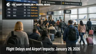
The US Flight Delays January 29, 2026 picture is a split day, forecast risk at several hubs, and at least one hub already showing measurable delay minutes. By late morning Eastern Time, LaGuardia was posting departure delays with a stated minimum of 31 minutes and a maximum of 45 minutes tied to wind, which is enough to break tight domestic connections and push aircraft off their planned gate turns for the next bank.
Who Is Affected
Travelers connecting through the Northeast and Mid Atlantic hubs are first in line, because winds do not just "add a few minutes," they can force runway configuration changes and increase required spacing on approach and departure. When that happens at a hub, the FAA and airlines typically meter demand to match a lower acceptance rate, and that metering often shows up as a delayed departure at your origin airport even if the origin weather looks calm. The second order effect is missed connections that cascade into rebooking friction, because the same constrained hub is also where the replacement seats need to flow.
Washington area itineraries have an extra wrinkle today, because DCA was showing an average ground delay around 44 minutes tied to snow or ice conditions in the late morning snapshot. That kind of ground delay often implies longer taxi out, deicing queues, or reduced runway throughput, and it can pull aircraft and crews off sequence for later legs into the Northeast and the Southeast. The ripple can become visible by afternoon as downstream delays or late day cancellations when duty time limits tighten.
Western hubs are not the headline, but they matter for national propagation. The FAA outlook flagged low clouds as a potential slowdown at Salt Lake City International Airport (SLC) and Seattle Tacoma International Airport (SEA), and even when those airports are technically "on time," low visibility conditions can push more conservative arrival rates and longer in trail spacing. That reduces schedule slack for carriers using those airports as banks for Mountain West and Pacific Northwest connections, which can then feed delay minutes into later transcontinental rotations.
What Travelers Should Do
Start with immediate actions and buffers. Check your flight status before you leave for the airport, then check again at the curb, because traffic management initiatives can activate quickly when winds or ceilings tighten. If your itinerary touches Logan, LaGuardia, Washington National, or any New York area connection, add time for slower taxi, longer gate holds, and more variable boarding times, and keep essentials in your personal item so an unexpected overnight is manageable without checked bags.
Use a decision threshold for rebooking versus waiting. If a delay compresses a hub connection under about 90 minutes for domestic to domestic, or under about 2 hours for domestic to international, treat that as a practical trigger to look for earlier departures, nonstop options, or routes that avoid the most constrained hubs. If you are on separate tickets, move faster, because the airline operating your first leg is not obligated to protect your onward segment, and rolling wind delays at a hub can erase your cushion without a single "big" cancellation event.
Over the next 24 to 72 hours, monitor three layers rather than one. Watch the FAA daily outlook for whether wind and ceiling constraints persist into the evening banks, watch the FAA command center planning notes for whether initiatives broaden, and watch your airline for waiver expansion that can turn a costly same day change into a no fee rebooking. If you want a quick baseline for how these weather driven metering days behave, compare today's setup with yesterday's pattern in Flight Delays and Airport Impacts: January 28, 2026.
How It Works
The FAA's air traffic system is built around safely matching demand to what each airport and its surrounding airspace can handle in a given hour. When gusty winds or low ceilings reduce the arrival or departure rate, the constraint starts at the runway, then propagates outward into gate availability, taxi flow, and arrival sequencing, because fewer aircraft can be processed per hour without increasing risk. That first order effect is why a hub can flip from "fine" to "behind" quickly during a bank when winds force a runway change or when ceilings drop into a more restrictive operating mode.
Traffic management tools are designed to keep that reduced throughput from turning into unsafe airborne congestion. Instead of letting aircraft stack overhead, the system often holds departures at the origin airport, assigns controlled departure times, or slows inbound streams. For travelers, that means your delay can start before pushback, even if the weather at your departure city is clear, because the destination hub is protecting its limited capacity. Once aircraft arrive late, gate turns slip, crews lose schedule margin, and the same airplane that was supposed to fly your next leg is now arriving behind plan, which is how a weather constraint at one hub becomes a multi hub network problem.
Those aviation ripples spill into the rest of the travel system in predictable ways. Missed connections push passengers into later departures, which increases standby and rebooking demand and can tighten availability for same day travel. Late arrivals also shift ground transportation peaks, so rideshare and taxi demand can spike at irregular hours, and hotel inventory near terminals can tighten when misconnects turn into overnight stays. On January 29, the combination of Northeast wind risk, Washington ground delays, and low ceiling sensitivity in the West is a classic setup for rolling delays that accumulate across the day, rather than a single shutdown event that is easy to plan around.
Sources
- FAA Daily Air Traffic Report
- ATCSCC Current Operations Plan Advisory
- FAA Airport Status, LaGuardia Airport (LGA)
- FAA Airport Status, Ronald Reagan Washington National Airport (DCA)
- FAA Airport Status, General Edward Lawrence Logan International Airport (BOS)
- FAA Airport Status, John F Kennedy International Airport (JFK)
- FAA Airport Status, Philadelphia International Airport (PHL)
- FAA Airport Status, Washington Dulles International Airport (IAD)
- FAA Airport Status, Baltimore Washington International Thurgood Marshall Airport (BWI)
- FAA Airport Status, Salt Lake City International Airport (SLC)
- FAA Airport Status, Seattle Tacoma International Airport (SEA)