Flight Delays and Airport Impacts: February 11, 2026
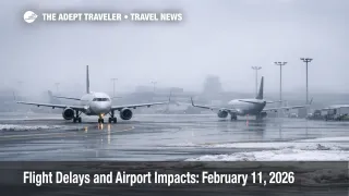
High winds on the West Coast and winter weather in the Northeast are the main drivers of U.S. delay risk today, with Los Angeles, California, San Diego, California, and San Francisco, California flagged in the FAA's daily outlook. Travelers connecting through Los Angeles International Airport (LAX), San Diego International Airport (SAN), and San Francisco International Airport (SFO) are most exposed, because wind and low ceilings can cut arrival rates and lengthen taxi times during peak banks. The practical move is to protect tight itineraries early, add buffer time, and avoid relying on the last flight of the day if your trip depends on making a connection.
The Flight delays February 11 2026 setup is a layered capacity risk, winds and low ceilings on the West Coast, snow at Boston, Massachusetts, and freezing rain plus low visibility risk in the New York airspace complex, which can trigger delay programs later in the day.
Who Is Affected
West Coast itineraries are first in line for disruption if winds verify at the airports that drive the region's connection flows. The FAA's daily outlook highlights wind risk at LAX, SAN, and SFO, and the FAA operations plan adds detail by listing terminal constraints for SFO tied to showers, wind, and low ceilings, plus wind constraints for LAX and SAN. The same operations plan frames a ground stop or delay program at SFO as probable later today, which matters because once SFO is metered, the ripple shows up quickly across California departures and across inbound connections from the Mountain West and the rest of the country. Even if the initial delays look modest, gate holds at the origin and arrival spacing at SFO can push aircraft out of position for their next legs.
Northeast travelers are exposed for a different reason, winter weather reduces usable capacity at the same time schedules are dense. The FAA daily outlook flags snow as a potential throughput constraint at Boston Logan, and it calls out freezing rain and low clouds in the New York area, Newark, New Jersey, New York, New York, and Queens, New York. The FAA operations plan reinforces that by listing Boston Logan under snow constraints and the New York terminal area, N90, under freezing rain and low visibility risk. When low visibility and icing concerns rise in that airspace, arrival rates can be trimmed, and that affects not only local flights but also the long chain of inbound aircraft that feed New York, Boston, and Washington connections.
Washington, District of Columbia itineraries may also see late day friction if the planned programs stack. The operations plan lists a possible ground stop or delay program at LaGuardia later today and another possible program at Reagan National later in the evening. Those programs matter most for travelers with tight hub transfers, late arrivals that are followed by long ground transfers, and anyone trying to protect a same day onward leg. Midday FAA snapshots for several of these airports show general conditions in the 15 minutes or less range, which often signals a day where disruption is expected to build later rather than remain severe all day. BOS, LAX, SAN, SFO, JFK, and EWR snapshots each show minor or no generalized delay indications at the time of the FAA updates, but the planning signals point to later programs that can shift the picture quickly.
What Travelers Should Do
Treat West Coast wind risk as a schedule geometry problem, not just a weather note. If your itinerary uses SFO, LAX, or SAN in the afternoon or evening, prioritize earlier departures, and pad connections beyond the minimums, because once taxi delays and arrival spacing increase, the system stops absorbing small slippages. If you have a must arrive event, move to a morning arrival window while seats still exist, and avoid building your plan around the last connecting bank.
Use a clear decision threshold so you act before rebooking inventory collapses. If a delay program at SFO becomes active or probable for your window, or if your connection margin through the New York area drops below what you can tolerate, rebook immediately rather than waiting for the airport to fully backlog. Separate tickets deserve a stricter threshold, because protection is not automatic, and a missed onward leg can turn into an out of pocket overnight.
Over the next 24 to 72 hours, monitor three signals that tend to predict whether a manageable day turns into irregular operations. First, watch whether winds and ceilings verify at the affected hubs, because that is what drives arrival rate reductions. Second, track ATCSCC advisories for explicit activation or extension of ground delay programs, because those are the clearest operational tells. Third, watch for airline waiver language, because that determines how cheaply you can shift to different flights or different days when conditions tighten. For a recent comparable daily pattern, see Flight Delays and Airport Impacts: February 10, 2026 and Flight Delays and Airport Impacts: February 9, 2026. For structural context on why localized constraints can still feel systemwide, see U.S. Air Traffic Control Privatization: Reality Check.
How It Works
Wind, low ceilings, and freezing rain reduce the rate at which aircraft can safely arrive and depart, even when the airport remains open and terminal conditions look normal. When winds rise or ceilings lower, controllers may need larger spacing on approach, airports may switch runway configurations, and departure queues can slow as surface movement gets constrained. That immediately limits throughput at the affected airport, which is why delay programs often show up around peak banks rather than at a constant level all day.
The first order effect is straightforward, fewer arrival slots, longer taxi times, and gate holds as aircraft wait for a controlled release. The second order ripple is what travelers feel, aircraft and crews arrive late to their next legs, connection windows shrink, and later flights inherit earlier delays even on routes far from the weather footprint. On days like February 11, when the West Coast has wind risk and the Northeast has winter weather risk, the network becomes vulnerable to compounding constraints because hubs are trying to recover at the same time.
Infrastructure and airspace programs can sharpen that effect. The FAA operations plan also notes ongoing runway and taxiway work at multiple airports, and it lists military activity and routing initiatives that can shape flows in parts of the system. Those elements do not automatically create a delay day on their own, but they reduce slack. When slack is lower, a weather driven reduction in arrival rate at SFO, or a low visibility regime in the New York terminal airspace, is more likely to cascade into missed connections, longer reaccommodation lines, and forced overnights for travelers trying to recover late in the day.
Sources
- FAA Daily Air Traffic Report
- Current Operations Plan Advisory
- General Edward Lawrence Logan International Airport (BOS) Real-time Status
- Los Angeles International Airport (LAX) Real-time Status
- San Diego-Lindbergh Field Airport (SAN) Real-time Status
- San Francisco International Airport (SFO) Real-time Status
- Newark International Airport (EWR) Real-time Status
- John F Kennedy International Airport (JFK) Real-time Status
- La Guardia Airport (LGA) Real-time Status
- DCA Airport Status