Flight Delays and Airport Impacts: March 1
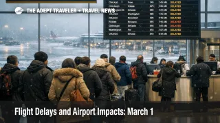
U.S. flight delays March 1 are being driven by a multi region constraint set that tends to convert ordinary delays into missed connections. The FAA's Air Traffic Control System Command Center operations plan flags snow, low ceilings, and reduced visibility around Boston, Massachusetts, and the New York airspace complex, while a Ground Delay Program is active at San Francisco International Airport (SFO). Low ceilings are also flagged for Los Angeles International Airport (LAX) and San Diego International Airport (SAN), and thunderstorm constraints remain in play on Florida routes. The practical move is to treat tight connections in the Northeast and into Florida as the main risk, then decide early whether you need to rebook before seats get chased by everyone at once.
The FAA Daily Air Traffic Report page does not yet show a dated entry for March 1, 2026, so today's planning signal is coming from Command Center operational advisories and weather tools instead.
U.S. Flight Delays March 1: What Changed
The most important change for March 1 is that the constraint set is no longer just "weather somewhere," it is weather plus flow management in several places that connect large parts of the network. The operations plan lists terminal constraints for Boston Logan International Airport (BOS) tied to snow and low ceilings, and it also calls out the New York TRACON complex (N90) for snow, low ceilings, visibility, and wind, which is the kind of mix that reduces arrival acceptance rates first.
On the West Coast, the plan shows an active Ground Delay Program at San Francisco, with low ceilings also flagged for Los Angeles and San Diego. That matters even if you are not touching California, because aircraft rotations often originate or terminate at SFO, then operate later legs to other hubs, which means a metered arrival bank in the Bay Area can quietly pull the schedule behind by late afternoon.
The plan also warns that Florida routes remain tactical under thunderstorms, including Center and route level constraints that can force reroutes and miles in trail spacing. This is the classic setup where the day can look manageable early, then degrade later as storms shift and traffic gets rebalanced.
Which Itineraries Are Most Exposed
Travelers connecting through Boston Logan International Airport (BOS) and the New York area airports, including John F. Kennedy International Airport (JFK), LaGuardia Airport (LGA), and Newark Liberty International Airport (EWR), are the most exposed to compounding delay risk because these airspace complexes propagate delays into multiple banks. In plain language, when snow and low ceilings reduce arrival rates, gates fill, departures wait for gate availability, and the delay migrates from one flight to many.
If your connection is under 90 minutes in the Northeast, treat it as a miss risk problem, not a comfort problem. Even a modest arrival throttle can erase your margin once taxi times grow, gates get reassigned, and crews run closer to duty limits.
Florida bound itineraries are the second big exposure, especially when you connect into Orlando International Airport (MCO), Miami International Airport (MIA), Fort Lauderdale Hollywood International Airport (FLL), Tampa International Airport (TPA), or other Florida stations that depend on a limited set of high volume north south flows. When thunderstorms push air routes into tactical management, the network "funnels" through fewer usable paths, which raises the odds of late day bunching and uneven holds.
West Coast travelers connecting through San Francisco International Airport (SFO) should assume metering is real today, and they should also treat Los Angeles International Airport (LAX) and San Diego International Airport (SAN) as slowdowns, not clean alternates, because low ceilings can constrain all three in the same cycle.
What Travelers Should Do Now
Start with buffers where the system actually breaks. If you are transiting Boston Logan, the New York area airports, or a Florida hub, add both airport arrival time and connection buffer. On days where arrival rates get throttled, the "first failure" is usually bank timing, so the safest place to buy resilience is margin between flights and earlier arrival for the first departure.
Use a decision threshold for rebooking versus waiting. Rebook early if your first leg is already slipping toward an hour late, if your connection is under 90 minutes, or if you are on separate tickets, because multi region constraint days drain the remaining seats faster than single airport events. Waiting only makes sense if you have multiple later options that still satisfy your real arrival constraint, not just your preferred arrival time.
Over the next 24 to 72 hours, monitor the FAA operations plan updates for whether Boston ground stops get activated, whether the San Francisco delay program extends, and whether Florida route constraints shift toward ground stops as storms organize. If you want a structural explainer for why these patterns recur and why recovery can persist after weather improves, see U.S. Air Traffic Control Privatization: Reality Check.
For context on yesterday's footprint and how quickly multi region constraints can turn into missed connections, see Flight Delays and Airport Impacts: Feb 28.
Why This Disruption Spreads Through Travel
A Ground Delay Program is a metering tool. Flights are held at their origin, so the arrival queue at the destination stays manageable. It is often used when ceilings or spacing requirements reduce the safe arrival rate, which is why SFO can become a "hidden" network constraint even for travelers who never route through California.
Snow and low ceilings in the Northeast tend to spread through travel in two steps. First order, arrivals get slowed, which increases airborne holding and compresses gate availability. Second order, departures get delayed because aircraft cannot park and turn, crews time out, and later flights inherit delays even if their local weather is fine. That is why the Boston and New York combination is more dangerous for connections than a single localized snow pocket.
Florida thunderstorm routing constraints spread differently. The first order effect is reroutes and miles in trail spacing that add block time and create uneven arrival "waves." The second order effect is misconnects into leisure destinations and cruise gateway cities, plus fewer same day rebooking options because the remaining capacity is concentrated on a smaller set of routes.